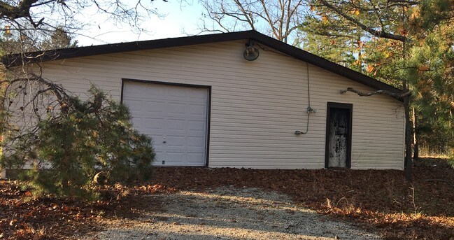
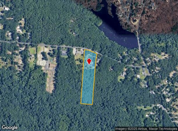
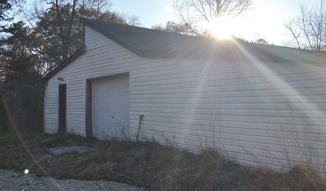
Property Record
294 Lanes Mill Rd, Howell, NJ 07731
NEARBY LISTINGS FOR SALE OR LEASE
Property Detail
294 Lanes Mill Rd
New York-Jersey City-White Plains, NY-NJ
Monmouth
21-00026-0000-00042
New Jersey
Sfr
6.11 AC
X
Western Monmouth
34025C0314F
Northern New Jersey
1,314 SF
DEMOGRAPHICS near 294 Lanes Mill Rd
1 Mile
3 Mile
5 Mile
2024 Total Population
1,864
78,463
179,159
2029 Population
1,837
79,712
183,976
Pop Growth 2024-2029
(1.45%)
+ 1.59%
+ 2.69%
Average Age
38
28
30
2024 Total Households
587
18,634
46,329
HH Growth 2024-2029
(1.70%)
+ 0.31%
+ 1.82%
Median Household Inc
$134,920
$82,655
$78,667
Avg Household Size
3.10
3.80
3.50
2024 Avg HH Vehicles
2.00
2.00
2.00
Median Home Value
$453,284
$419,489
$383,913
Median Year Built
1981
1982
1984
Nearby Places
Map Layers
Map Styles
 Street
 Aerial
- Restaurants
- Banks
- Shops
- Fitness
- Groceries
SALE & LEASE HISTORY
LISTING DATE
SALE/LEASE

Dec 04, 2018
For Lease
Nearby Properties
Address
Land Use
TOTAL SIZE
Lot Size
Zoning
Address
Land Use
TOTAL SIZE
Lot Size
Zoning
113.02 AC
R12
Address
Land Use
TOTAL SIZE
Lot Size
Zoning
24.15 AC
MF
Address
Land Use
TOTAL SIZE
Lot Size
Zoning
105.04 AC
SED
Address
Land Use
TOTAL SIZE
Lot Size
Zoning
2,382 SF
341 AC
OSP
Address
Land Use
TOTAL SIZE
Lot Size
Zoning
161,340 SF
35.35 AC
HD-1
Address
Land Use
TOTAL SIZE
Lot Size
Zoning
21,876 SF
22.26 AC
B3
Address
Land Use
TOTAL SIZE
Lot Size
Zoning
36.25 AC
R12
Address
Land Use
TOTAL SIZE
Lot Size
Zoning
28.99 AC
HD-1
Address
Land Use
TOTAL SIZE
Lot Size
Zoning
94,380 SF
8.71 AC
B4
Address
Land Use
TOTAL SIZE
Lot Size
Zoning
14.73 AC
R-5
Address
Land Use
TOTAL SIZE
Lot Size
Zoning
37,202 SF
14.79 AC
B3
Address
Land Use
TOTAL SIZE
Lot Size
Zoning
162,000 SF
34.35 AC
ARE2
Address
Land Use
TOTAL SIZE
Lot Size
Zoning
8,784 SF
16.16 AC
R-LM
Address
Land Use
TOTAL SIZE
Lot Size
Zoning
1,825 SF
49.38 AC
OSP
Address
Land Use
TOTAL SIZE
Lot Size
Zoning
17.08 AC
R15
Address
Land Use
TOTAL SIZE
Lot Size
Zoning
1,270 SF
3.65 AC
R12
Address
Land Use
TOTAL SIZE
Lot Size
Zoning
360,400 SF
35.98 AC
SED
Address
Land Use
TOTAL SIZE
Lot Size
Zoning
2,736 SF
18.04 AC
R15
Address
Land Use
TOTAL SIZE
Lot Size
Zoning
127,932 SF
2.41 AC
R-OP
Address
Land Use
TOTAL SIZE
Lot Size
Zoning
3.64 AC
R10
Address
Land Use
TOTAL SIZE
Lot Size
Zoning
96,503 SF
2.26 AC
R-OP
Address
Land Use
TOTAL SIZE
Lot Size
Zoning
26,473 SF
0.72 AC
R-OP
Address
Land Use
TOTAL SIZE
Lot Size
Zoning
98,731 SF
13.65 AC
HD
Address
Land Use
TOTAL SIZE
Lot Size
Zoning
83,396 SF
9.51 AC
R15
Address
Land Use
TOTAL SIZE
Lot Size
Zoning
141,437 SF
13.35 AC
HD-1
Address
Land Use
TOTAL SIZE
Lot Size
Zoning
125,379 SF
22.16 AC
HD
Address
Land Use
TOTAL SIZE
Lot Size
Zoning
66,990 SF
4.19 AC
RM
Address
Land Use
TOTAL SIZE
Lot Size
Zoning
51,531 SF
13.30 AC
HD
Address
Land Use
TOTAL SIZE
Lot Size
Zoning
6.80 AC
HC
Address
Land Use
TOTAL SIZE
Lot Size
Zoning
4.24 AC
RM
The World's #1 Commercial Real Estate Marketplace
Connect with us
© 2025 CoStar Group
The information above has been obtained from sources believed reliable. While we do not doubt its accuracy we have not verified it and make no guarantee, warranty or representation about it. It is your responsibility to independently confirm its accuracy and completeness. Any projections, opinions, assumptions, or estimates used are for example only and do not represent the current or future performance of the property. The value of this transaction to you depends on tax and other factors which should be evaluated by your tax, financial, and legal advisors. You and your advisors should conduct a careful, independent investigation of the property to determine to your satisfaction the suitability of the property for your needs.