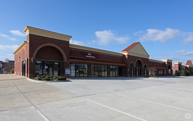
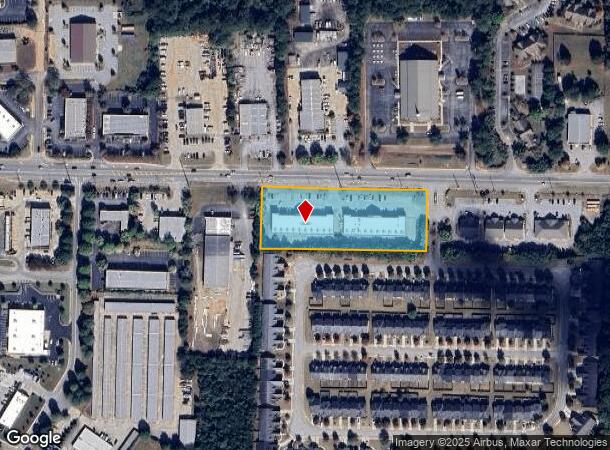
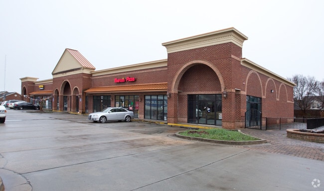
Property Record
294 Racetrack Rd, Mcdonough, GA 30252

NEARBY LISTINGS FOR SALE OR LEASE
-
-
View all Mcdonough listings for lease on LoopNet.com
Property Detail
294 Racetrack Rd
0108-01-017-021
LD: 7LL: 167
Stripcommercialcenter
Henry
X
Georgia
13151C0167D
167
2025
2.49 AC
2025
McDonough/Butts
070209
Atlanta
30,601 SF
Atlanta-Sandy Springs-Roswell, GA
DEMOGRAPHICS near 294 Racetrack Rd
1 Mile
3 Mile
5 Mile
2024 Total Population
6,007
40,587
82,247
2029 Population
6,586
44,504
90,270
Pop Growth 2024-2029
+ 9.64%
+ 9.65%
+ 9.75%
Average Age
36
36
37
2024 Total Households
2,163
14,590
28,940
HH Growth 2024-2029
+ 9.66%
+ 9.75%
+ 9.90%
Median Household Inc
$52,875
$68,463
$77,011
Avg Household Size
2.70
2.70
2.80
2024 Avg HH Vehicles
2.00
2.00
2.00
Median Home Value
$179,882
$232,726
$248,237
Median Year Built
2003
2002
2003
Nearby Places
Map Layers
Map Styles
 Street
 Aerial
- Restaurants
- Banks
- Shops
- Fitness
- Groceries
PUBLIC TRANSPORTATION
AIRPORT
Hartsfield - Jackson Atlanta International
DRIVE
WALK
Distance
Hartsfield - Jackson Atlanta International
36 min
27.0 mi
SALE & LEASE HISTORY
LISTING DATE
SALE/LEASE

Sep 25, 2016
For Lease
May 03, 2017
For Lease
Nearby Properties
Address
Land Use
TOTAL SIZE
Lot Size
Zoning
Address
Land Use
TOTAL SIZE
Lot Size
Zoning
33,565 SF
44.68 AC
Address
Land Use
TOTAL SIZE
Lot Size
Zoning
1,573,998 SF
84.31 AC
M2
Address
Land Use
TOTAL SIZE
Lot Size
Zoning
1,079,756 SF
92.38 AC
M1
Address
Land Use
TOTAL SIZE
Lot Size
Zoning
3,973,920 SF
88.41 AC
I
Address
Land Use
TOTAL SIZE
Lot Size
Zoning
1,226,687 SF
100.81 AC
M2
Address
Land Use
TOTAL SIZE
Lot Size
Zoning
10,092 SF
46.06 AC
RM
Address
Land Use
TOTAL SIZE
Lot Size
Zoning
29,768 SF
50.81 AC
RM
Address
Land Use
TOTAL SIZE
Lot Size
Zoning
27,336 SF
27.95 AC
Address
Land Use
TOTAL SIZE
Lot Size
Zoning
247,544 SF
43.30 AC
Address
Land Use
TOTAL SIZE
Lot Size
Zoning
2,337,242 SF
71.11 AC
M2
Address
Land Use
TOTAL SIZE
Lot Size
Zoning
21,880 SF
22.04 AC
RMH
Address
Land Use
TOTAL SIZE
Lot Size
Zoning
6,422 SF
24.67 AC
RM
Address
Land Use
TOTAL SIZE
Lot Size
Zoning
1,588,692 SF
44.95 AC
M1
Address
Land Use
TOTAL SIZE
Lot Size
Zoning
11,256 SF
34.51 AC
RM
Address
Land Use
TOTAL SIZE
Lot Size
Zoning
415,997 SF
41.35 AC
Address
Land Use
TOTAL SIZE
Lot Size
Zoning
40,500 SF
27.66 AC
RA
Address
Land Use
TOTAL SIZE
Lot Size
Zoning
6,344 SF
21.40 AC
C1
Address
Land Use
TOTAL SIZE
Lot Size
Zoning
18,084 SF
59.72 AC
M1
Address
Land Use
TOTAL SIZE
Lot Size
Zoning
4,982 SF
34.62 AC
RM
Address
Land Use
TOTAL SIZE
Lot Size
Zoning
4,237,908 SF
44.42 AC
M
Address
Land Use
TOTAL SIZE
Lot Size
Zoning
25,622 SF
17.43 AC
RMH
Address
Land Use
TOTAL SIZE
Lot Size
Zoning
1,456,864 SF
82.62 AC
Address
Land Use
TOTAL SIZE
Lot Size
Zoning
3,877,368 SF
44.93 AC
M2
Address
Land Use
TOTAL SIZE
Lot Size
Zoning
2,877,520 SF
53.73 AC
C2
Address
Land Use
TOTAL SIZE
Lot Size
Zoning
23,400 SF
29 AC
RM
Address
Land Use
TOTAL SIZE
Lot Size
Zoning
40,246 SF
13.73 AC
Address
Land Use
TOTAL SIZE
Lot Size
Zoning
297,736 SF
57.04 AC
M
Address
Land Use
TOTAL SIZE
Lot Size
Zoning
532,585 SF
67.79 AC
M2
Address
Land Use
TOTAL SIZE
Lot Size
Zoning
3,114 SF
15.44 AC
RM
Address
Land Use
TOTAL SIZE
Lot Size
Zoning
1,122,282 SF
39.20 AC
M2
The World's #1 Commercial Real Estate Marketplace
Connect with us
© 2026 CoStar Group
The information above has been obtained from sources believed reliable. While we do not doubt its accuracy we have not verified it and make no guarantee, warranty or representation about it. It is your responsibility to independently confirm its accuracy and completeness. Any projections, opinions, assumptions, or estimates used are for example only and do not represent the current or future performance of the property. The value of this transaction to you depends on tax and other factors which should be evaluated by your tax, financial, and legal advisors. You and your advisors should conduct a careful, independent investigation of the property to determine to your satisfaction the suitability of the property for your needs.