Property Record
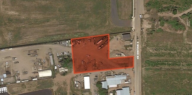
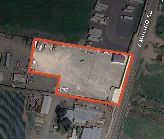
294 S Walnut St, Canby, OR 97013
Property Detail
294 S Walnut St
00798088
31E34 02300
Industrialgeneral
CLACKAMAS
M1
Oregon
B and X Area of moderate flood hazard, usually the area between the limits of the 100-year and 500-year floods.
5.02 AC
0
SE Outlying
2025
Portland
022901
Portland-Vancouver-Hillsboro, OR-WA
1,598 SF
NEARBY LISTINGS FOR SALE OR LEASE
DEMOGRAPHICS near 294 S Walnut St
1 mile
3 mile
5 mile
2025 Total Population
4,162
22,734
35,521
2030 Population
4,236
22,957
35,560
Pop Growth 2025-2030
+ 1.78%
+ 0.98%
+ 0.11%
Average Age
40
42
44
2025 Total Households
1,487
8,253
13,086
HH Growth 2025-2030
+ 1.82%
+ 1.04%
+ 0.11%
Median Household Inc
$105,300
$102,419
$106,051
Avg Household Size
2.80
2.70
2.70
2025 Avg HH Vehicles
2.00
2.00
2.00
Median Home Value
$634,972
$544,518
$629,043
Median Year Built
1996
1991
1990
Nearby Places
Map Layers
Map Styles
 Street
 Aerial
Transit
 Traffic
 Biking
Places
Listings with unknown addresses are not visible on the map
- Restaurants
- Banks
- Shops
- Fitness
- Groceries
PUBLIC TRANSPORTATION
COMMUTER RAIL
Oregon City Amtrak (Amtrak Cascades - Amtrak)
Drive
Walk
Distance
Oregon City Amtrak (Amtrak Cascades - Amtrak)
17 min
9.7 mi
AIRPORT
Portland International
Drive
Walk
Distance
Portland International
43 min
27.4 mi
Freight Ports
Port of Portland
Drive
Walk
Distance
Port of Portland
44 min
29.3 mi
SALE & LEASE HISTORY
LISTING DATE
SALE/LEASE

Nov 08, 2022
For Lease
Nearby Properties
Address
Land Use
TOTAL SIZE
Lot Size
Zoning
Address
Land Use
TOTAL SIZE
Lot Size
Zoning
Address
Land Use
TOTAL SIZE
Lot Size
Zoning
35.33 AC
M1
Address
Land Use
TOTAL SIZE
Lot Size
Zoning
1,432 SF
12.96 AC
CM
Address
Land Use
TOTAL SIZE
Lot Size
Zoning
10 AC
M2
Address
Land Use
TOTAL SIZE
Lot Size
Zoning
4.88 AC
R1.5
Address
Land Use
TOTAL SIZE
Lot Size
Zoning
9.26 AC
M1
Address
Land Use
TOTAL SIZE
Lot Size
Zoning
17.39 AC
M1
Address
Land Use
TOTAL SIZE
Lot Size
Zoning
15.17 AC
M2
Address
Land Use
TOTAL SIZE
Lot Size
Zoning
Address
Land Use
TOTAL SIZE
Lot Size
Zoning
1 SF
7 AC
C2
Address
Land Use
TOTAL SIZE
Lot Size
Zoning
828 SF
0.74 AC
C1
Address
Land Use
TOTAL SIZE
Lot Size
Zoning
6.11 AC
M1
Address
Land Use
TOTAL SIZE
Lot Size
Zoning
7 AC
M2
Address
Land Use
TOTAL SIZE
Lot Size
Zoning
13.91 AC
M1
Address
Land Use
TOTAL SIZE
Lot Size
Zoning
3 AC
CM
Address
Land Use
TOTAL SIZE
Lot Size
Zoning
4.39 AC
R2
Address
Land Use
TOTAL SIZE
Lot Size
Zoning
9.48 AC
M1
Address
Land Use
TOTAL SIZE
Lot Size
Zoning
11.34 AC
M1
Address
Land Use
TOTAL SIZE
Lot Size
Zoning
Address
Land Use
TOTAL SIZE
Lot Size
Zoning
1,863 SF
0.32 AC
R2
Address
Land Use
TOTAL SIZE
Lot Size
Zoning
47.55 AC
M1
Address
Land Use
TOTAL SIZE
Lot Size
Zoning
5 AC
M2
Address
Land Use
TOTAL SIZE
Lot Size
Zoning
Address
Land Use
TOTAL SIZE
Lot Size
Zoning
5.84 AC
Address
Land Use
TOTAL SIZE
Lot Size
Zoning
4.89 AC
M1
Address
Land Use
TOTAL SIZE
Lot Size
Zoning
7.95 AC
R2
Address
Land Use
TOTAL SIZE
Lot Size
Zoning
16.26 AC
M1
Address
Land Use
TOTAL SIZE
Lot Size
Zoning
3 AC
M2
Address
Land Use
TOTAL SIZE
Lot Size
Zoning
5.93 AC
M1
Address
Land Use
TOTAL SIZE
Lot Size
Zoning
9 AC
M1
The World's #1 Commercial Real Estate Marketplace
Connect with us
© 2026 CoStar Group
The information above has been obtained from sources believed reliable. While we do not doubt its accuracy we have not verified it and make no guarantee, warranty or representation about it. It is your responsibility to independently confirm its accuracy and completeness. Any projections, opinions, assumptions, or estimates used are for example only and do not represent the current or future performance of the property. The value of this transaction to you depends on tax and other factors which should be evaluated by your tax, financial, and legal advisors. You and your advisors should conduct a careful, independent investigation of the property to determine to your satisfaction the suitability of the property for your needs.