Property Record
2940 Baker Rd, Dexter, MI 48130
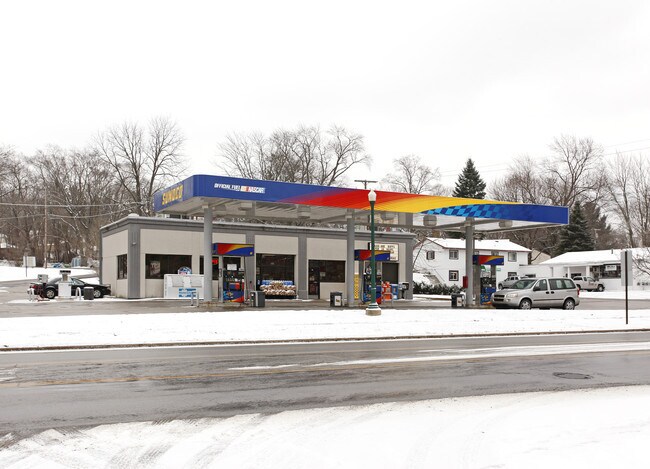

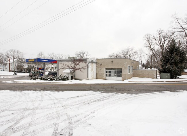
Property Detail
2940 Baker Rd
08-06-426-001
ENTIRE BLOCK BLK 26 ORIGINAL PLAT.
Commercialnec
WASHTENAW
C-1
Michigan
B and X Area of moderate flood hazard, usually the area between the limits of the 100-year and 500-year floods.
0.41 AC
2025
Washtenaw W of 23
2025
Detroit
461000
Ann Arbor, MI
2,108 SF
NEARBY LISTINGS FOR SALE OR LEASE
DEMOGRAPHICS near 2940 Baker Rd
1 mile
3 mile
5 mile
2025 Total Population
4,089
9,219
24,315
2030 Population
4,137
9,280
24,482
Pop Growth 2025-2030
+ 1.17%
+ 0.66%
+ 0.69%
Average Age
42
43
42
2025 Total Households
1,635
3,512
9,160
HH Growth 2025-2030
+ 1.28%
+ 0.74%
+ 0.81%
Median Household Inc
$105,960
$121,692
$124,853
Avg Household Size
2.50
2.60
2.60
2025 Avg HH Vehicles
2.00
2.00
2.00
Median Home Value
$408,758
$445,107
$454,902
Median Year Built
1991
1991
1991
Nearby Places
Map Layers
Map Styles
 Street
 Aerial
Transit
 Traffic
 Biking
Places
Listings with unknown addresses are not visible on the map
- Restaurants
- Banks
- Shops
- Fitness
- Groceries
PUBLIC TRANSPORTATION
COMMUTER RAIL
Drive
Walk
Distance
17 min
8.7 mi
AIRPORT
Detroit Metro Wayne County
Drive
Walk
Distance
Detroit Metro Wayne County
47 min
37.2 mi
Nearby Properties
Address
Land Use
TOTAL SIZE
Lot Size
Zoning
Address
Land Use
TOTAL SIZE
Lot Size
Zoning
132,280 SF
10.29 AC
I-1
Address
Land Use
TOTAL SIZE
Lot Size
Zoning
460,082 SF
42.24 AC
RD
Address
Land Use
TOTAL SIZE
Lot Size
Zoning
148,595 SF
13.28 AC
I-1
Address
Land Use
TOTAL SIZE
Lot Size
Zoning
443,838 SF
47.01 AC
I-1
Address
Land Use
TOTAL SIZE
Lot Size
Zoning
24.06 AC
R-3
Address
Land Use
TOTAL SIZE
Lot Size
Zoning
2,913 SF
25.61 AC
C-3
Address
Land Use
TOTAL SIZE
Lot Size
Zoning
61,760 SF
18.06 AC
II
Address
Land Use
TOTAL SIZE
Lot Size
Zoning
52,990 SF
20.49 AC
I-1
Address
Land Use
TOTAL SIZE
Lot Size
Zoning
Address
Land Use
TOTAL SIZE
Lot Size
Zoning
13.36 AC
R-3
Address
Land Use
TOTAL SIZE
Lot Size
Zoning
Address
Land Use
TOTAL SIZE
Lot Size
Zoning
49,707 SF
4.50 AC
C-1
Address
Land Use
TOTAL SIZE
Lot Size
Zoning
31,970 SF
8.34 AC
C-1
Address
Land Use
TOTAL SIZE
Lot Size
Zoning
54,150 SF
20.19 AC
I-1
Address
Land Use
TOTAL SIZE
Lot Size
Zoning
88,590 SF
9.80 AC
RD
Address
Land Use
TOTAL SIZE
Lot Size
Zoning
129,600 SF
10.27 AC
I-1
Address
Land Use
TOTAL SIZE
Lot Size
Zoning
11.82 AC
SEVERAL
Address
Land Use
TOTAL SIZE
Lot Size
Zoning
89,881 SF
12.25 AC
I-1
Address
Land Use
TOTAL SIZE
Lot Size
Zoning
150,000 SF
18.24 AC
I-1
Address
Land Use
TOTAL SIZE
Lot Size
Zoning
68,000 SF
11.61 AC
RD
Address
Land Use
TOTAL SIZE
Lot Size
Zoning
70,200 SF
8.06 AC
IRP
Address
Land Use
TOTAL SIZE
Lot Size
Zoning
84,460 SF
IFT PARCEL
Address
Land Use
TOTAL SIZE
Lot Size
Zoning
67,262 SF
9.05 AC
C-1
Address
Land Use
TOTAL SIZE
Lot Size
Zoning
4,788 SF
14.35 AC
SEVERAL
Address
Land Use
TOTAL SIZE
Lot Size
Zoning
43,293 SF
2.20 AC
RD
Address
Land Use
TOTAL SIZE
Lot Size
Zoning
15,444 SF
3.28 AC
PB
Address
Land Use
TOTAL SIZE
Lot Size
Zoning
576 SF
IFT PARCEL
Address
Land Use
TOTAL SIZE
Lot Size
Zoning
38,304 SF
5.76 AC
C-4
Address
Land Use
TOTAL SIZE
Lot Size
Zoning
21,870 SF
0.46 AC
VILLAGE
Address
Land Use
TOTAL SIZE
Lot Size
Zoning
54,400 SF
5 AC
I-1
The World's #1 Commercial Real Estate Marketplace
Connect with us
© 2026 CoStar Group
The information above has been obtained from sources believed reliable. While we do not doubt its accuracy we have not verified it and make no guarantee, warranty or representation about it. It is your responsibility to independently confirm its accuracy and completeness. Any projections, opinions, assumptions, or estimates used are for example only and do not represent the current or future performance of the property. The value of this transaction to you depends on tax and other factors which should be evaluated by your tax, financial, and legal advisors. You and your advisors should conduct a careful, independent investigation of the property to determine to your satisfaction the suitability of the property for your needs.