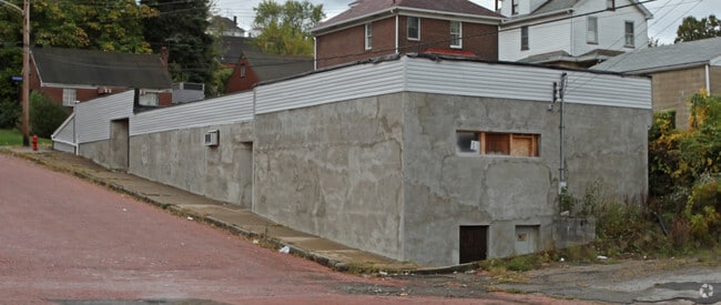
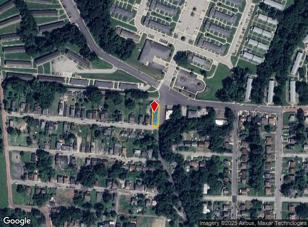
Property Record
2941 Chester St, Mckeesport, PA 15132

NEARBY LISTINGS FOR SALE OR LEASE
Property Detail
2941 Chester St
Pittsburgh, PA
S A Soles Plan
0380-L-00024-0000-00
S A SOLES PLAN 46 LOT 35.8XAVG121.12X33.88 RR C HESTER ST COR OHIO 1 STY STONE & C B BLDG TAVERN 2941
Bartavern
Allegheny
X
Pennsylvania
42003C0502H
24
2024
0.10 AC
2025
Parkway East Corridor
552300
Pittsburgh
DEMOGRAPHICS near 2941 Chester St
1 Mile
3 Mile
5 Mile
2024 Total Population
15,436
59,592
143,699
2029 Population
15,670
59,266
142,621
Pop Growth 2024-2029
+ 1.52%
(0.55%)
(0.75%)
Average Age
41
43
43
2024 Total Households
6,557
26,868
65,429
HH Growth 2024-2029
+ 1.37%
(0.70%)
(0.85%)
Median Household Inc
$31,765
$43,384
$47,069
Avg Household Size
2.20
2.10
2.10
2024 Avg HH Vehicles
1.00
1.00
1.00
Median Home Value
$63,176
$82,622
$97,905
Median Year Built
1949
1952
1953
Nearby Places
Map Layers
Map Styles
 Street
 Aerial
- Restaurants
- Banks
- Shops
- Fitness
- Groceries
PUBLIC TRANSPORTATION
AIRPORT
Arnold Palmer Regional
DRIVE
WALK
Distance
Arnold Palmer Regional
52 min
27.9 mi
Pittsburgh International
DRIVE
WALK
Distance
Pittsburgh International
54 min
32.5 mi
Nearby Properties
Address
Land Use
TOTAL SIZE
Lot Size
Zoning
Address
Land Use
TOTAL SIZE
Lot Size
Zoning
5.98 AC
Address
Land Use
TOTAL SIZE
Lot Size
Zoning
49.22 AC
Address
Land Use
TOTAL SIZE
Lot Size
Zoning
Address
Land Use
TOTAL SIZE
Lot Size
Zoning
10.68 AC
Address
Land Use
TOTAL SIZE
Lot Size
Zoning
1.39 AC
Address
Land Use
TOTAL SIZE
Lot Size
Zoning
11.31 AC
Address
Land Use
TOTAL SIZE
Lot Size
Zoning
29.17 AC
Address
Land Use
TOTAL SIZE
Lot Size
Zoning
121.64 AC
Address
Land Use
TOTAL SIZE
Lot Size
Zoning
43.15 AC
Address
Land Use
TOTAL SIZE
Lot Size
Zoning
10.93 AC
Address
Land Use
TOTAL SIZE
Lot Size
Zoning
24.63 AC
Address
Land Use
TOTAL SIZE
Lot Size
Zoning
969 SF
80.46 AC
Address
Land Use
TOTAL SIZE
Lot Size
Zoning
Address
Land Use
TOTAL SIZE
Lot Size
Zoning
Address
Land Use
TOTAL SIZE
Lot Size
Zoning
Address
Land Use
TOTAL SIZE
Lot Size
Zoning
10.13 AC
Address
Land Use
TOTAL SIZE
Lot Size
Zoning
10.01 AC
Address
Land Use
TOTAL SIZE
Lot Size
Zoning
12.56 AC
Address
Land Use
TOTAL SIZE
Lot Size
Zoning
2.10 AC
Address
Land Use
TOTAL SIZE
Lot Size
Zoning
24.85 AC
Address
Land Use
TOTAL SIZE
Lot Size
Zoning
10.27 AC
Address
Land Use
TOTAL SIZE
Lot Size
Zoning
Address
Land Use
TOTAL SIZE
Lot Size
Zoning
4.59 AC
Address
Land Use
TOTAL SIZE
Lot Size
Zoning
15.07 AC
Address
Land Use
TOTAL SIZE
Lot Size
Zoning
0.79 AC
Address
Land Use
TOTAL SIZE
Lot Size
Zoning
16.87 AC
Address
Land Use
TOTAL SIZE
Lot Size
Zoning
24.86 AC
Address
Land Use
TOTAL SIZE
Lot Size
Zoning
13.93 AC
Address
Land Use
TOTAL SIZE
Lot Size
Zoning
Address
Land Use
TOTAL SIZE
Lot Size
Zoning
The World's #1 Commercial Real Estate Marketplace
Connect with us
© 2025 CoStar Group
The information above has been obtained from sources believed reliable. While we do not doubt its accuracy we have not verified it and make no guarantee, warranty or representation about it. It is your responsibility to independently confirm its accuracy and completeness. Any projections, opinions, assumptions, or estimates used are for example only and do not represent the current or future performance of the property. The value of this transaction to you depends on tax and other factors which should be evaluated by your tax, financial, and legal advisors. You and your advisors should conduct a careful, independent investigation of the property to determine to your satisfaction the suitability of the property for your needs.