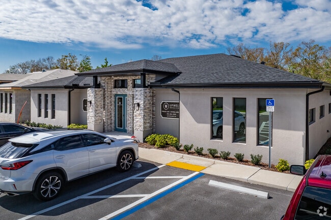
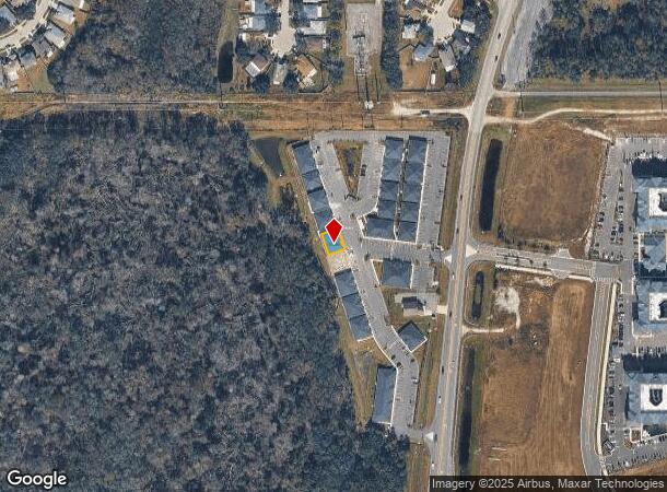
Property Record
2943 Allegra Way, Lutz, FL 33559

NEARBY LISTINGS FOR SALE OR LEASE
Property Detail
2943 Allegra Way
Tampa/St Petersburg
Worthington Gardens
Tampa-St. Petersburg-Clearwater, FL
COM AT NW COR OF SEC 27 TH N89DEG4811E 547.19 FT TH S00DEG1149E 100 FT TH N89DEG4811E 272.75 FT TH S00DEG1149E 339.76 FT TO POB TH N71DEG4814E 53 FT TH S18DEG1146E 18 FT TH S71DEG4814W 3 FT TH S18DEG1146E 7.83 FT TH N71DEG4814E 3.17 FT TH S18DEG1146E
27-26-19-0010-00000-0500
Pasco
Officebuilding
Florida
2024
5
2025
0.08 AC
032010
Pasco County
3,496 SF
DEMOGRAPHICS near 2943 Allegra Way
1 Mile
3 Mile
5 Mile
2024 Total Population
3,855
51,846
116,811
2029 Population
4,602
61,558
137,031
Pop Growth 2024-2029
+ 19.38%
+ 18.73%
+ 17.31%
Average Age
38
39
39
2024 Total Households
1,462
18,921
42,813
HH Growth 2024-2029
+ 19.36%
+ 18.74%
+ 17.30%
Median Household Inc
$88,461
$99,192
$100,677
Avg Household Size
2.60
2.70
2.70
2024 Avg HH Vehicles
2.00
2.00
2.00
Median Home Value
$276,418
$325,859
$341,004
Median Year Built
2000
2003
2003
Nearby Places
Map Layers
Map Styles
 Street
 Aerial
- Restaurants
- Banks
- Shops
- Fitness
- Groceries
PUBLIC TRANSPORTATION
AIRPORT
Tampa International
DRIVE
WALK
Distance
Tampa International
37 min
27.3 mi
St Pete-Clearwater International
DRIVE
WALK
Distance
St Pete-Clearwater International
54 min
36.5 mi
Freight Ports
Port of Tampa Bay
DRIVE
WALK
Distance
Port of Tampa Bay
33 min
22.9 mi
Nearby Properties
Address
Land Use
TOTAL SIZE
Lot Size
Zoning
Address
Land Use
TOTAL SIZE
Lot Size
Zoning
455,090 SF
52.24 AC
MPUD
Address
Land Use
TOTAL SIZE
Lot Size
Zoning
603,350 SF
28.81 AC
MPUD
Address
Land Use
TOTAL SIZE
Lot Size
Zoning
380,937 SF
13.58 AC
MPUD
Address
Land Use
TOTAL SIZE
Lot Size
Zoning
38,091 SF
43.42 AC
MPUD
Address
Land Use
TOTAL SIZE
Lot Size
Zoning
366,691 SF
51.90 AC
MPUD
Address
Land Use
TOTAL SIZE
Lot Size
Zoning
425,129 SF
12.72 AC
MPUD
Address
Land Use
TOTAL SIZE
Lot Size
Zoning
347,708 SF
43.40 AC
MPUD
Address
Land Use
TOTAL SIZE
Lot Size
Zoning
346,880 SF
20.01 AC
MPUD
Address
Land Use
TOTAL SIZE
Lot Size
Zoning
324,184 SF
19.12 AC
MPUD
Address
Land Use
TOTAL SIZE
Lot Size
Zoning
269,998 SF
12.25 AC
MPUD
Address
Land Use
TOTAL SIZE
Lot Size
Zoning
285,532 SF
57.73 AC
MF1
Address
Land Use
TOTAL SIZE
Lot Size
Zoning
263,289 SF
26.30 AC
MPUD
Address
Land Use
TOTAL SIZE
Lot Size
Zoning
267,326 SF
22.50 AC
MPUD
Address
Land Use
TOTAL SIZE
Lot Size
Zoning
279,167 SF
14.75 AC
MPUD
Address
Land Use
TOTAL SIZE
Lot Size
Zoning
192,698 SF
19.31 AC
MPUD
Address
Land Use
TOTAL SIZE
Lot Size
Zoning
138,949 SF
11.74 AC
MPUD
Address
Land Use
TOTAL SIZE
Lot Size
Zoning
147,238 SF
13.89 AC
MPUD
Address
Land Use
TOTAL SIZE
Lot Size
Zoning
62,553 SF
43.31 AC
PD
Address
Land Use
TOTAL SIZE
Lot Size
Zoning
136,319 SF
26.11 AC
MPUD
Address
Land Use
TOTAL SIZE
Lot Size
Zoning
89,269 SF
9.42 AC
C2
Address
Land Use
TOTAL SIZE
Lot Size
Zoning
83,294 SF
7.68 AC
MPUD
Address
Land Use
TOTAL SIZE
Lot Size
Zoning
86,782 SF
12.21 AC
C2
Address
Land Use
TOTAL SIZE
Lot Size
Zoning
85,151 SF
23.18 AC
C2
Address
Land Use
TOTAL SIZE
Lot Size
Zoning
96,210 SF
0.85 AC
MPUD
Address
Land Use
TOTAL SIZE
Lot Size
Zoning
88,803 SF
6.46 AC
C2
Address
Land Use
TOTAL SIZE
Lot Size
Zoning
106,061 SF
14.01 AC
MPUD
Address
Land Use
TOTAL SIZE
Lot Size
Zoning
63,500 SF
32.29 AC
PD
Address
Land Use
TOTAL SIZE
Lot Size
Zoning
118,112 SF
10.41 AC
MF1
Address
Land Use
TOTAL SIZE
Lot Size
Zoning
98,841 SF
3.81 AC
MPUD
Address
Land Use
TOTAL SIZE
Lot Size
Zoning
63,427 SF
12.17 AC
C2
The World's #1 Commercial Real Estate Marketplace
Connect with us
© 2025 CoStar Group
The information above has been obtained from sources believed reliable. While we do not doubt its accuracy we have not verified it and make no guarantee, warranty or representation about it. It is your responsibility to independently confirm its accuracy and completeness. Any projections, opinions, assumptions, or estimates used are for example only and do not represent the current or future performance of the property. The value of this transaction to you depends on tax and other factors which should be evaluated by your tax, financial, and legal advisors. You and your advisors should conduct a careful, independent investigation of the property to determine to your satisfaction the suitability of the property for your needs.