Property Record
2943 W Grand Blvd, Detroit, MI 48202

NEARBY LISTINGS FOR SALE OR LEASE
Property Detail
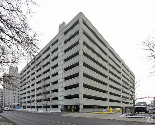
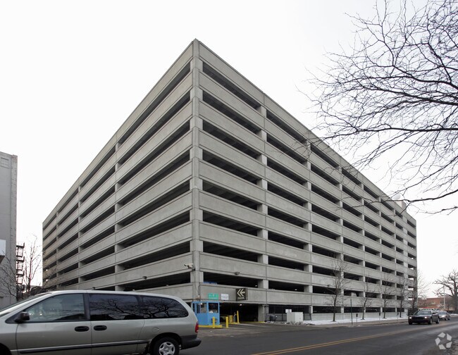
2943 W Grand Blvd
04-00153-640
Lothrop & Duffields
Parkingstructure
S LOTHROP LOTS 165 THRU 163 ; PT OF LOTS 162 & 166 THRU 171 AND VAC ALLEY ADJ; LOTHROP & DUFFIELDS SUB L17 P22 PLATS, DESC AS FOLS: COMM AT NW COR OF LOT 158; LOTHROP & DUFFIELDS SUB, SD PTE BG INTSEC SLY LINE LOTHROP AVE 80 FT WD & THIRD AVE 80 FT W
X
Wayne
26163C0280E
Michigan
2025
1.44 AC
2025
Detroit-New Center
533900
Detroit
531,360 SF
Detroit-Warren-Dearborn, MI
DEMOGRAPHICS near 2943 W Grand Blvd
1 Mile
3 Mile
5 Mile
2024 Total Population
18,304
144,901
352,291
2029 Population
18,299
145,287
352,525
Pop Growth 2024-2029
(0.03%)
+ 0.27%
+ 0.07%
Average Age
37
38
38
2024 Total Households
8,631
61,800
144,516
HH Growth 2024-2029
+ 0.14%
+ 0.58%
+ 0.22%
Median Household Inc
$32,255
$32,627
$34,795
Avg Household Size
1.80
2.20
2.30
2024 Avg HH Vehicles
1.00
1.00
1.00
Median Home Value
$197,466
$100,253
$86,025
Median Year Built
1948
1948
1948
Nearby Places
Map Layers
Map Styles
 Street
 Aerial
- Restaurants
- Banks
- Shops
- Fitness
- Groceries
PUBLIC TRANSPORTATION
COMMUTER RAIL
DRIVE
WALK
Distance
2 min
9 min
0.5 mi
DRIVE
WALK
Distance
16 min
7.5 mi
AIRPORT
Windsor International
DRIVE
WALK
Distance
Windsor International
30 min
13.4 mi
Detroit Metro Wayne County
DRIVE
WALK
Distance
Detroit Metro Wayne County
33 min
21.8 mi
Freight Ports
DRIVE
WALK
Distance
79 min
62.5 mi
Nearby Properties
Address
Land Use
TOTAL SIZE
Lot Size
Zoning
Address
Land Use
TOTAL SIZE
Lot Size
Zoning
3,032,363 SF
24.24 AC
SD5
Address
Land Use
TOTAL SIZE
Lot Size
Zoning
409,438 SF
0.83 AC
B6
Address
Land Use
TOTAL SIZE
Lot Size
Zoning
1,409,416 SF
13.53 AC
R6
Address
Land Use
TOTAL SIZE
Lot Size
Zoning
1,994,989 SF
4.97 AC
B5
Address
Land Use
TOTAL SIZE
Lot Size
Zoning
873,048 SF
7.70 AC
R6
Address
Land Use
TOTAL SIZE
Lot Size
Zoning
1,017,009 SF
1.35 AC
R6
Address
Land Use
TOTAL SIZE
Lot Size
Zoning
848,598 SF
8.78 AC
SD5
Address
Land Use
TOTAL SIZE
Lot Size
Zoning
252,150 SF
2.46 AC
SD5
Address
Land Use
TOTAL SIZE
Lot Size
Zoning
185,300 SF
3.36 AC
SD5
Address
Land Use
TOTAL SIZE
Lot Size
Zoning
3,793,609 SF
265.70 AC
M4
Address
Land Use
TOTAL SIZE
Lot Size
Zoning
503,688 SF
Address
Land Use
TOTAL SIZE
Lot Size
Zoning
919,213 SF
B5
Address
Land Use
TOTAL SIZE
Lot Size
Zoning
568,546 SF
B5
Address
Land Use
TOTAL SIZE
Lot Size
Zoning
306,496 SF
1.91 AC
R6
Address
Land Use
TOTAL SIZE
Lot Size
Zoning
187,652 SF
Address
Land Use
TOTAL SIZE
Lot Size
Zoning
268,746 SF
B5
Address
Land Use
TOTAL SIZE
Lot Size
Zoning
576,286 SF
1.66 AC
B4
Address
Land Use
TOTAL SIZE
Lot Size
Zoning
328,284 SF
768.89 AC
PD
Address
Land Use
TOTAL SIZE
Lot Size
Zoning
268,114 SF
2.46 AC
B6
Address
Land Use
TOTAL SIZE
Lot Size
Zoning
324,379 SF
4.97 AC
B5
Address
Land Use
TOTAL SIZE
Lot Size
Zoning
246,212 SF
B5
Address
Land Use
TOTAL SIZE
Lot Size
Zoning
334,904 SF
B5
Address
Land Use
TOTAL SIZE
Lot Size
Zoning
1,017,597 SF
2.73 AC
B5
Address
Land Use
TOTAL SIZE
Lot Size
Zoning
302,517 SF
2.50 AC
B4
Address
Land Use
TOTAL SIZE
Lot Size
Zoning
627,489 SF
5.82 AC
B4
Address
Land Use
TOTAL SIZE
Lot Size
Zoning
235,468 SF
1.50 AC
B5
Address
Land Use
TOTAL SIZE
Lot Size
Zoning
210,426 SF
1.97 AC
B4
Address
Land Use
TOTAL SIZE
Lot Size
Zoning
236,576 SF
B5
Address
Land Use
TOTAL SIZE
Lot Size
Zoning
346,191 SF
0.66 AC
B5
Address
Land Use
TOTAL SIZE
Lot Size
Zoning
192,497 SF
B5
The World's #1 Commercial Real Estate Marketplace
Connect with us
© 2026 CoStar Group
The information above has been obtained from sources believed reliable. While we do not doubt its accuracy we have not verified it and make no guarantee, warranty or representation about it. It is your responsibility to independently confirm its accuracy and completeness. Any projections, opinions, assumptions, or estimates used are for example only and do not represent the current or future performance of the property. The value of this transaction to you depends on tax and other factors which should be evaluated by your tax, financial, and legal advisors. You and your advisors should conduct a careful, independent investigation of the property to determine to your satisfaction the suitability of the property for your needs.