Property Record
2944 Avalon Blvd, Milton, FL 32583

NEARBY LISTINGS FOR SALE OR LEASE
-
-
View all Milton listings for sale on LoopNet.com
Property Detail
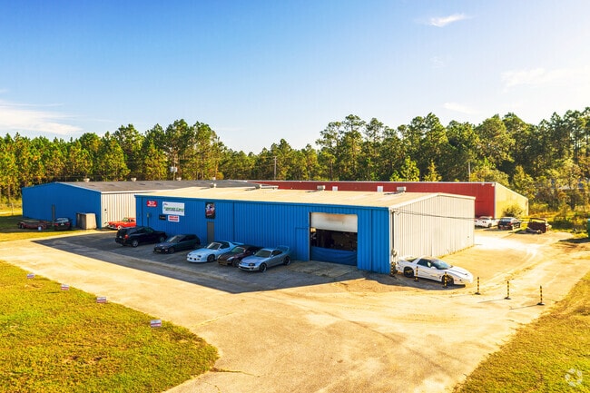
2944 Avalon Blvd
Pensacola-Ferry Pass-Brent, FL
Avalon Beach
40-1N-28-0090-52700-0010
AVALON BEACH LOTS 1-9 & 16-24 BLK 527 AS DES IN OR 841 PG 620 & THAT PORT OF 20 FT VAC ALLEY LYING BETWEEN SAID LTS AS DES IN OR 732 PG 6 & OR 3605 PG 1525
Lightindustrial
Santa Rosa
X
Florida
12113C0440H
1
2024
3.10 AC
2025
Avalon Beach/Milton
010709
Pensacola
21,064 SF
DEMOGRAPHICS near 2944 Avalon Blvd
1 Mile
3 Mile
5 Mile
2024 Total Population
1,118
6,290
24,884
2029 Population
1,292
7,294
28,648
Pop Growth 2024-2029
+ 15.56%
+ 15.96%
+ 15.13%
Average Age
41
41
40
2024 Total Households
439
2,434
9,509
HH Growth 2024-2029
+ 15.72%
+ 16.27%
+ 15.46%
Median Household Inc
$92,269
$100,806
$79,692
Avg Household Size
2.50
2.60
2.60
2024 Avg HH Vehicles
2.00
2.00
2.00
Median Home Value
$274,073
$256,177
$231,976
Median Year Built
2003
2001
1998
Nearby Places
Map Layers
Map Styles
 Street
 Aerial
- Restaurants
- Banks
- Shops
- Fitness
- Groceries
PUBLIC TRANSPORTATION
AIRPORT
Pensacola International
DRIVE
WALK
Distance
Pensacola International
22 min
12.7 mi
Freight Ports
Port of Mobile
DRIVE
WALK
Distance
Port of Mobile
71 min
62.8 mi
SALE & LEASE HISTORY
LISTING DATE
SALE/LEASE

Oct 19, 2023
For Sale
Jul 18, 2018
For Lease
Nearby Properties
Address
Land Use
TOTAL SIZE
Lot Size
Zoning
Address
Land Use
TOTAL SIZE
Lot Size
Zoning
118,887 SF
19.24 AC
HCD
Address
Land Use
TOTAL SIZE
Lot Size
Zoning
615,804 SF
16.46 AC
M2
Address
Land Use
TOTAL SIZE
Lot Size
Zoning
115,095 SF
7.44 AC
HCD
Address
Land Use
TOTAL SIZE
Lot Size
Zoning
40,026 SF
1.79 AC
HCD
Address
Land Use
TOTAL SIZE
Lot Size
Zoning
37,232 SF
303.14 AC
HCD
Address
Land Use
TOTAL SIZE
Lot Size
Zoning
14,800 SF
44.73 AC
M1
Address
Land Use
TOTAL SIZE
Lot Size
Zoning
18,920 SF
3.65 AC
R3
Address
Land Use
TOTAL SIZE
Lot Size
Zoning
17,449 SF
39.90 AC
R1
Address
Land Use
TOTAL SIZE
Lot Size
Zoning
25,935 SF
3.42 AC
HCD
Address
Land Use
TOTAL SIZE
Lot Size
Zoning
5,800 SF
148.82 AC
M2
Address
Land Use
TOTAL SIZE
Lot Size
Zoning
15,370 SF
12.15 AC
M2
Address
Land Use
TOTAL SIZE
Lot Size
Zoning
38,500 SF
2.73 AC
HCD
Address
Land Use
TOTAL SIZE
Lot Size
Zoning
10,095 SF
1.03 AC
HCD
Address
Land Use
TOTAL SIZE
Lot Size
Zoning
22,259 SF
45.80 AC
M2
Address
Land Use
TOTAL SIZE
Lot Size
Zoning
9,081 SF
1.88 AC
HCD
Address
Land Use
TOTAL SIZE
Lot Size
Zoning
5,181 SF
55.05 AC
M2
Address
Land Use
TOTAL SIZE
Lot Size
Zoning
15,375 SF
1.85 AC
M1
Address
Land Use
TOTAL SIZE
Lot Size
Zoning
10,008 SF
1.10 AC
HCD
Address
Land Use
TOTAL SIZE
Lot Size
Zoning
1,485 SF
3.14 AC
HCD
Address
Land Use
TOTAL SIZE
Lot Size
Zoning
11,241 SF
1.50 AC
HCD
Address
Land Use
TOTAL SIZE
Lot Size
Zoning
25,323 SF
2 AC
HCD
Address
Land Use
TOTAL SIZE
Lot Size
Zoning
627 SF
2.07 AC
HCD
Address
Land Use
TOTAL SIZE
Lot Size
Zoning
4,327 SF
0.83 AC
HCD
Address
Land Use
TOTAL SIZE
Lot Size
Zoning
8,679 SF
1.35 AC
HCD
Address
Land Use
TOTAL SIZE
Lot Size
Zoning
10,349 SF
0.69 AC
HCD
Address
Land Use
TOTAL SIZE
Lot Size
Zoning
6,006 SF
0.83 AC
HCD
The World's #1 Commercial Real Estate Marketplace
Connect with us
© 2025 CoStar Group
The information above has been obtained from sources believed reliable. While we do not doubt its accuracy we have not verified it and make no guarantee, warranty or representation about it. It is your responsibility to independently confirm its accuracy and completeness. Any projections, opinions, assumptions, or estimates used are for example only and do not represent the current or future performance of the property. The value of this transaction to you depends on tax and other factors which should be evaluated by your tax, financial, and legal advisors. You and your advisors should conduct a careful, independent investigation of the property to determine to your satisfaction the suitability of the property for your needs.