Property Record
2944 Se Lund Ave, Port Orchard, WA 98366
NEARBY LISTINGS FOR SALE OR LEASE
-
-
View all Port Orchard listings for sale on LoopNet.com
Property Detail
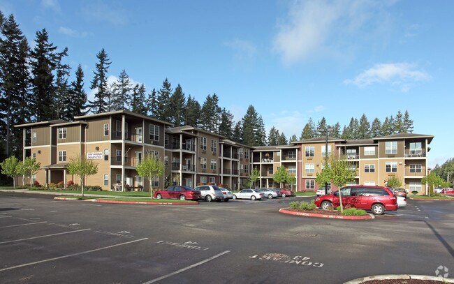
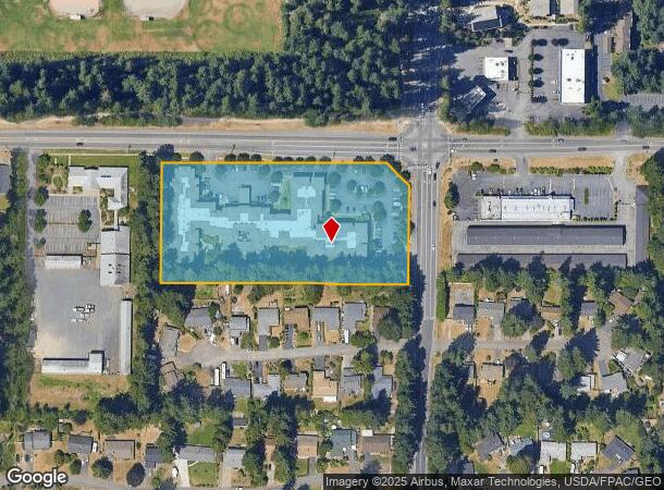
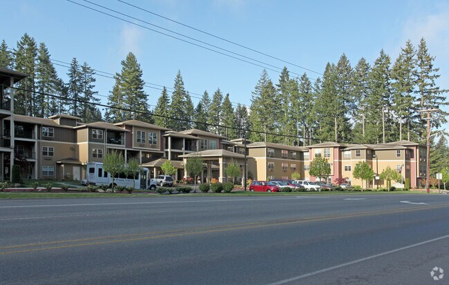
2944 Se Lund Ave
Bremerton-Silverdale-Port Orchard, WA
Timber Meadows
012301-1-024-2007
THE NORTH HALF OF THE NORTHEAST QUARTER OF THE NORTHEAST QUARTER OF THE NORTHEAST QUARTER OF SECTION 1, TOWNSHIP 23 NORTH, RANGE 1 EAST, W.M.; EXCEPT THE NORTH AND WEST 20 FEET; AND EXCEPT PORTION CONVEYED TO KITSAP COUNTY FOR COUNTY ROAD NO. 405 AND
Retirementnursinghomecombined
Kitsap
X
Washington
53035C0390F
24
2025
4.02 AC
2026
Port Orchard
092300
Bremerton/Silverdale
125,582 SF
DEMOGRAPHICS near 2944 Se Lund Ave
1 Mile
3 Mile
5 Mile
2024 Total Population
9,919
37,378
98,160
2029 Population
10,045
37,852
99,423
Pop Growth 2024-2029
+ 1.27%
+ 1.27%
+ 1.29%
Average Age
39
40
40
2024 Total Households
3,805
14,061
37,203
HH Growth 2024-2029
+ 1.21%
+ 1.22%
+ 1.45%
Median Household Inc
$72,739
$75,802
$73,993
Avg Household Size
2.50
2.50
2.40
2024 Avg HH Vehicles
2.00
2.00
2.00
Median Home Value
$365,273
$401,921
$417,801
Median Year Built
1981
1984
1981
Nearby Places
Map Layers
Map Styles
 Street
 Aerial
- Restaurants
- Banks
- Shops
- Fitness
- Groceries
PUBLIC TRANSPORTATION
AIRPORT
Seattle-Tacoma International
DRIVE
WALK
Distance
Seattle-Tacoma International
69 min
48.1 mi
Freight Ports
Port of Seattle
DRIVE
WALK
Distance
Port of Seattle
79 min
58.4 mi
Nearby Properties
Address
Land Use
TOTAL SIZE
Lot Size
Zoning
Address
Land Use
TOTAL SIZE
Lot Size
Zoning
552 SF
17.39 AC
CITY
Address
Land Use
TOTAL SIZE
Lot Size
Zoning
143,022 SF
11.24 AC
R4
Address
Land Use
TOTAL SIZE
Lot Size
Zoning
127,853 SF
7.41 AC
R4
Address
Land Use
TOTAL SIZE
Lot Size
Zoning
135,371 SF
6.04 AC
R4
Address
Land Use
TOTAL SIZE
Lot Size
Zoning
17,592 SF
11.61 AC
UM
Address
Land Use
TOTAL SIZE
Lot Size
Zoning
25,973 SF
8.20 AC
CC
Address
Land Use
TOTAL SIZE
Lot Size
Zoning
110,994 SF
5.35 AC
R4
Address
Land Use
TOTAL SIZE
Lot Size
Zoning
1,092 SF
5.70 AC
CC
Address
Land Use
TOTAL SIZE
Lot Size
Zoning
0.54 AC
CITY
Address
Land Use
TOTAL SIZE
Lot Size
Zoning
110,778 SF
9.24 AC
CC
Address
Land Use
TOTAL SIZE
Lot Size
Zoning
158,870 SF
14.62 AC
CC
Address
Land Use
TOTAL SIZE
Lot Size
Zoning
185,893 SF
17.89 AC
CC
Address
Land Use
TOTAL SIZE
Lot Size
Zoning
77,580 SF
8.62 AC
UM
Address
Land Use
TOTAL SIZE
Lot Size
Zoning
14,660 SF
6.14 AC
UM
Address
Land Use
TOTAL SIZE
Lot Size
Zoning
14,660 SF
6.07 AC
UM
Address
Land Use
TOTAL SIZE
Lot Size
Zoning
49,604 SF
5.49 AC
UM
Address
Land Use
TOTAL SIZE
Lot Size
Zoning
62,642 SF
4.91 AC
UM
Address
Land Use
TOTAL SIZE
Lot Size
Zoning
56,006 SF
4.72 AC
UM
Address
Land Use
TOTAL SIZE
Lot Size
Zoning
45,379 SF
6.74 AC
UM
Address
Land Use
TOTAL SIZE
Lot Size
Zoning
69,192 SF
3.36 AC
UM
Address
Land Use
TOTAL SIZE
Lot Size
Zoning
2.33 AC
CITY
Address
Land Use
TOTAL SIZE
Lot Size
Zoning
138,087 SF
14.24 AC
CC
Address
Land Use
TOTAL SIZE
Lot Size
Zoning
68,708 SF
7.89 AC
PF
Address
Land Use
TOTAL SIZE
Lot Size
Zoning
520 SF
7.79 AC
C
Address
Land Use
TOTAL SIZE
Lot Size
Zoning
39,800 SF
4.69 AC
CC
Address
Land Use
TOTAL SIZE
Lot Size
Zoning
67,000 SF
4.19 AC
C
Address
Land Use
TOTAL SIZE
Lot Size
Zoning
43,318 SF
2.54 AC
R4
Address
Land Use
TOTAL SIZE
Lot Size
Zoning
85,187 SF
4.30 AC
CC
Address
Land Use
TOTAL SIZE
Lot Size
Zoning
75,000 SF
3.61 AC
LI
The World's #1 Commercial Real Estate Marketplace
Connect with us
© 2026 CoStar Group
The information above has been obtained from sources believed reliable. While we do not doubt its accuracy we have not verified it and make no guarantee, warranty or representation about it. It is your responsibility to independently confirm its accuracy and completeness. Any projections, opinions, assumptions, or estimates used are for example only and do not represent the current or future performance of the property. The value of this transaction to you depends on tax and other factors which should be evaluated by your tax, financial, and legal advisors. You and your advisors should conduct a careful, independent investigation of the property to determine to your satisfaction the suitability of the property for your needs.