Property Record
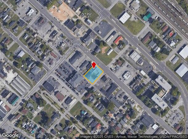
2944 Winchester Ave, Ashland, KY 41101

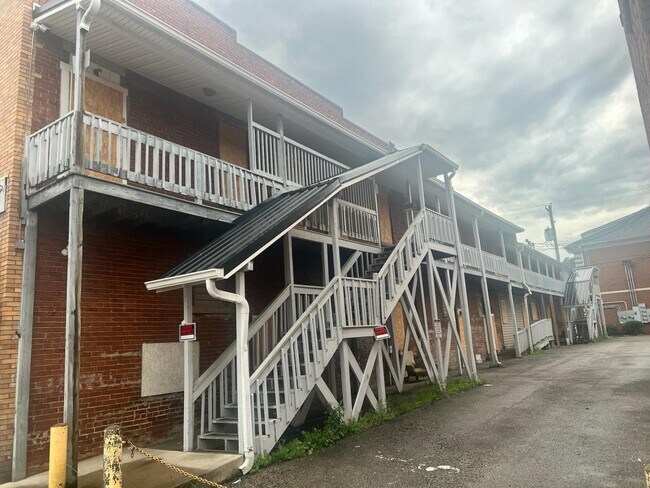
This Property Is For Sale
NEARBY LISTINGS FOR SALE OR LEASE
Property Detail
2944 Winchester Ave
Huntington-Ashland, WV-KY-OH
Geiger Addition
038-08-08-008.00
LOTS 45 46 & PART LOT 47-48 GEIGER ADDITION
Taxexempt
Boyd
X
Kentucky
21019C0076E
46
0
0.12 AC
2024
Downtown Ashland
030200
Huntington/Ashland
DEMOGRAPHICS near 2944 Winchester Ave
1 Mile
3 Mile
5 Mile
2024 Total Population
4,136
29,043
52,120
2029 Population
4,146
28,662
51,237
Pop Growth 2024-2029
+ 0.24%
(1.31%)
(1.69%)
Average Age
40
41
42
2024 Total Households
1,829
12,280
21,578
HH Growth 2024-2029
+ 0.22%
(1.23%)
(1.62%)
Median Household Inc
$37,500
$45,274
$50,445
Avg Household Size
2.10
2.30
2.30
2024 Avg HH Vehicles
2.00
2.00
2.00
Median Home Value
$87,910
$110,920
$117,986
Median Year Built
1956
1964
1966
Nearby Places
- Restaurants
- Banks
- Shops
- Fitness
- Groceries
PUBLIC TRANSPORTATION
COMMUTER RAIL
Ashland Amtrak Station (Cardinal - Amtrak)
DRIVE
WALK
Distance
Ashland Amtrak Station (Cardinal - Amtrak)
2 min
1.3 mi
AIRPORT
Tri-State/Milton J Ferguson Field
DRIVE
WALK
Distance
Tri-State/Milton J Ferguson Field
19 min
10.6 mi
Freight Ports
Port of Toledo
DRIVE
WALK
Distance
Port of Toledo
335 min
258.6 mi
Nearby Properties
Address
Land Use
TOTAL SIZE
Lot Size
Zoning
Address
Land Use
TOTAL SIZE
Lot Size
Zoning
6.96 AC
Z02
Address
Land Use
TOTAL SIZE
Lot Size
Zoning
36.49 AC
OTHER
Address
Land Use
TOTAL SIZE
Lot Size
Zoning
29.92 AC
Z02
Address
Land Use
TOTAL SIZE
Lot Size
Zoning
3,514 SF
21.96 AC
Z02
Address
Land Use
TOTAL SIZE
Lot Size
Zoning
0.99 AC
Z02
Address
Land Use
TOTAL SIZE
Lot Size
Zoning
16.29 AC
COMMERCIAL
Address
Land Use
TOTAL SIZE
Lot Size
Zoning
116,640 SF
0.97 AC
COMMERCIAL
Address
Land Use
TOTAL SIZE
Lot Size
Zoning
4.47 AC
COMMERCIAL
Address
Land Use
TOTAL SIZE
Lot Size
Zoning
28.87 AC
COMMERCIAL
Address
Land Use
TOTAL SIZE
Lot Size
Zoning
91,786 SF
2.93 AC
Address
Land Use
TOTAL SIZE
Lot Size
Zoning
0.73 AC
Z02
Address
Land Use
TOTAL SIZE
Lot Size
Zoning
0.38 AC
COMMERCIAL
Address
Land Use
TOTAL SIZE
Lot Size
Zoning
1.67 AC
RESIDENTIA
Address
Land Use
TOTAL SIZE
Lot Size
Zoning
1.63 AC
COMMERCIAL
Address
Land Use
TOTAL SIZE
Lot Size
Zoning
1.95 AC
COMMERCIAL
Address
Land Use
TOTAL SIZE
Lot Size
Zoning
4.30 AC
COMMERCIAL
Address
Land Use
TOTAL SIZE
Lot Size
Zoning
22,592 SF
43.50 AC
OTHER
Address
Land Use
TOTAL SIZE
Lot Size
Zoning
141 AC
COMMERCIAL
Address
Land Use
TOTAL SIZE
Lot Size
Zoning
47,107 SF
4.67 AC
Address
Land Use
TOTAL SIZE
Lot Size
Zoning
8,364 SF
3 AC
Z02
Address
Land Use
TOTAL SIZE
Lot Size
Zoning
1.46 AC
COMMERCIAL
Address
Land Use
TOTAL SIZE
Lot Size
Zoning
Address
Land Use
TOTAL SIZE
Lot Size
Zoning
0.21 AC
Z02
Address
Land Use
TOTAL SIZE
Lot Size
Zoning
3.50 AC
Z02
Address
Land Use
TOTAL SIZE
Lot Size
Zoning
1,920 SF
33.30 AC
Z03
Address
Land Use
TOTAL SIZE
Lot Size
Zoning
97,299 SF
8.82 AC
Address
Land Use
TOTAL SIZE
Lot Size
Zoning
0.57 AC
COMMERCIAL
Address
Land Use
TOTAL SIZE
Lot Size
Zoning
16,632 SF
1.07 AC
COMMERCIAL
Address
Land Use
TOTAL SIZE
Lot Size
Zoning
54.65 AC
Address
Land Use
TOTAL SIZE
Lot Size
Zoning
The World's #1 Commercial Real Estate Marketplace
Connect with us
© 2025 CoStar Group
The information above has been obtained from sources believed reliable. While we do not doubt its accuracy we have not verified it and make no guarantee, warranty or representation about it. It is your responsibility to independently confirm its accuracy and completeness. Any projections, opinions, assumptions, or estimates used are for example only and do not represent the current or future performance of the property. The value of this transaction to you depends on tax and other factors which should be evaluated by your tax, financial, and legal advisors. You and your advisors should conduct a careful, independent investigation of the property to determine to your satisfaction the suitability of the property for your needs.