Property Record
2945 Liberty Rd S, Salem, OR 97302


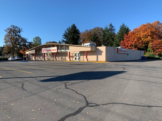

This Property Is For Sale
Current Lease Availabilities
Property Detail
2945 Liberty Rd S
531323
ACRES 2.00
Officebuilding
Marion
CR
Oregon
B and X Area of moderate flood hazard, usually the area between the limits of the 100-year and 500-year floods.
2 AC
2024
Marion County
2025
Portland
002201
Salem, OR
18,844 SF
NEARBY LISTINGS FOR SALE OR LEASE
DEMOGRAPHICS near 2945 Liberty Rd S
1 mile
3 mile
5 mile
2025 Total Population
14,992
89,477
195,339
2030 Population
15,111
90,546
197,465
Pop Growth 2025-2030
+ 0.79%
+ 1.19%
+ 1.09%
Average Age
41
40
39
2025 Total Households
6,480
34,146
71,151
HH Growth 2025-2030
+ 0.93%
+ 1.23%
+ 1.15%
Median Household Inc
$75,728
$76,134
$72,757
Avg Household Size
2.30
2.40
2.60
2025 Avg HH Vehicles
2.00
2.00
2.00
Median Home Value
$461,386
$448,900
$428,431
Median Year Built
1966
1974
1978
Nearby Places
Map Layers
Map Styles
 Street
 Aerial
Layers
 Traffic
 Biking
Places
Listings with unknown addresses are not visible on the map
- Restaurants
- Banks
- Shops
- Fitness
- Groceries
PUBLIC TRANSPORTATION
COMMUTER RAIL
Salem (Amtrak Cascades - Amtrak, Coast Starlight - Amtrak)
Drive
Walk
Distance
Salem (Amtrak Cascades - Amtrak, Coast Starlight - Amtrak)
5 min
2.2 mi
Freight Ports
Port of Portland
Drive
Walk
Distance
Port of Portland
71 min
54.1 mi
Nearby Properties
Address
Land Use
TOTAL SIZE
Lot Size
Zoning
Address
Land Use
TOTAL SIZE
Lot Size
Zoning
978,999 SF
25.74 AC
PE
Address
Land Use
TOTAL SIZE
Lot Size
Zoning
236,837 SF
20.76 AC
PE
Address
Land Use
TOTAL SIZE
Lot Size
Zoning
118,829 SF
3.49 AC
CB
Address
Land Use
TOTAL SIZE
Lot Size
Zoning
145,520 SF
1.70 AC
PM
Address
Land Use
TOTAL SIZE
Lot Size
Zoning
120,642 SF
4 AC
CB
Address
Land Use
TOTAL SIZE
Lot Size
Zoning
305,230 SF
9.76 AC
PS
Address
Land Use
TOTAL SIZE
Lot Size
Zoning
166,344 SF
1.70 AC
PM
Address
Land Use
TOTAL SIZE
Lot Size
Zoning
183,400 SF
7.17 AC
PE; CB
Address
Land Use
TOTAL SIZE
Lot Size
Zoning
264,504 SF
28.17 AC
PS
Address
Land Use
TOTAL SIZE
Lot Size
Zoning
Address
Land Use
TOTAL SIZE
Lot Size
Zoning
137,002 SF
6.27 AC
PE
Address
Land Use
TOTAL SIZE
Lot Size
Zoning
33,560 SF
4.95 AC
CR
Address
Land Use
TOTAL SIZE
Lot Size
Zoning
122,260 SF
2.32 AC
PE
Address
Land Use
TOTAL SIZE
Lot Size
Zoning
122,333 SF
0.48 AC
CB
Address
Land Use
TOTAL SIZE
Lot Size
Zoning
98,733 SF
1.13 AC
CB
Address
Land Use
TOTAL SIZE
Lot Size
Zoning
77,198 SF
1.71 AC
PM
Address
Land Use
TOTAL SIZE
Lot Size
Zoning
209,780 SF
19.85 AC
IC
Address
Land Use
TOTAL SIZE
Lot Size
Zoning
170,756 SF
2.65 AC
PS
Address
Land Use
TOTAL SIZE
Lot Size
Zoning
62,708 SF
30.21 AC
PH
Address
Land Use
TOTAL SIZE
Lot Size
Zoning
114,647 SF
5.72 AC
RM2; RM1
Address
Land Use
TOTAL SIZE
Lot Size
Zoning
102,124 SF
10.53 AC
CR
Address
Land Use
TOTAL SIZE
Lot Size
Zoning
105,152 SF
2.39 AC
CR
Address
Land Use
TOTAL SIZE
Lot Size
Zoning
1,769,016 SF
20.58 AC
CR
Address
Land Use
TOTAL SIZE
Lot Size
Zoning
108,723 SF
7.12 AC
IC
Address
Land Use
TOTAL SIZE
Lot Size
Zoning
85,536 SF
10.25 AC
PS
Address
Land Use
TOTAL SIZE
Lot Size
Zoning
55,589 SF
6.20 AC
PH
Address
Land Use
TOTAL SIZE
Lot Size
Zoning
514,875 SF
28.02 AC
IG
Address
Land Use
TOTAL SIZE
Lot Size
Zoning
136,853 SF
13.32 AC
IC
Address
Land Use
TOTAL SIZE
Lot Size
Zoning
144,782 SF
1.24 AC
CB
The World's #1 Commercial Real Estate Marketplace
Connect with us
© 2026 CoStar Group
The information above has been obtained from sources believed reliable. While we do not doubt its accuracy we have not verified it and make no guarantee, warranty or representation about it. It is your responsibility to independently confirm its accuracy and completeness. Any projections, opinions, assumptions, or estimates used are for example only and do not represent the current or future performance of the property. The value of this transaction to you depends on tax and other factors which should be evaluated by your tax, financial, and legal advisors. You and your advisors should conduct a careful, independent investigation of the property to determine to your satisfaction the suitability of the property for your needs.