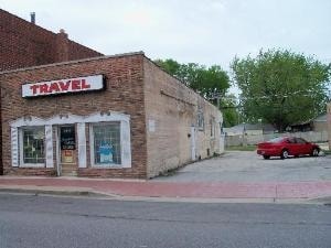
Property Record
2946 W 95Th St, Evergreen Park, IL 60805

NEARBY LISTINGS FOR SALE OR LEASE
Property Detail
2946 W 95Th St
Taxexempt
Cook
X
Illinois
17031C0630J
0.76 AC
2021
Near South Cook
2024
Chicago
821800
Chicago-Naperville-Elgin, IL-IN-WI
1,576 SF
24-01-326-046-0000
DEMOGRAPHICS near 2946 W 95Th St
1 Mile
3 Mile
5 Mile
2024 Total Population
19,026
211,209
565,948
2029 Population
18,372
203,948
544,798
Pop Growth 2024-2029
(3.44%)
(3.44%)
(3.74%)
Average Age
40
41
40
2024 Total Households
6,755
77,280
202,117
HH Growth 2024-2029
(3.79%)
(3.77%)
(4.01%)
Median Household Inc
$90,714
$69,723
$55,208
Avg Household Size
2.70
2.60
2.70
2024 Avg HH Vehicles
2.00
2.00
1.00
Median Home Value
$246,251
$227,725
$200,681
Median Year Built
1953
1954
1954
Nearby Places
Map Layers
Map Styles
 Street
 Aerial
- Restaurants
- Banks
- Shops
- Fitness
- Groceries
PUBLIC TRANSPORTATION
COMMUTER RAIL
95th Street Station (Rock Island District Line - Northeast Illinois Regional Commuter Railroad (Metra))
DRIVE
WALK
Distance
95th Street Station (Rock Island District Line - Northeast Illinois Regional Commuter Railroad (Metra))
3 min
1.6 mi
99th Street Station (Rock Island District Line - Northeast Illinois Regional Commuter Railroad (Metra))
DRIVE
WALK
Distance
99th Street Station (Rock Island District Line - Northeast Illinois Regional Commuter Railroad (Metra))
5 min
2.3 mi
AIRPORT
Chicago Midway International
DRIVE
WALK
Distance
Chicago Midway International
13 min
7.1 mi
Chicago O'Hare International
DRIVE
WALK
Distance
Chicago O'Hare International
61 min
30.9 mi
Nearby Properties
Address
Land Use
TOTAL SIZE
Lot Size
Zoning
Address
Land Use
TOTAL SIZE
Lot Size
Zoning
87,830 SF
0.76 AC
B1-1
Address
Land Use
TOTAL SIZE
Lot Size
Zoning
48,792 SF
8.71 AC
RT-4
Address
Land Use
TOTAL SIZE
Lot Size
Zoning
240,300 SF
3.72 AC
Address
Land Use
TOTAL SIZE
Lot Size
Zoning
63,930 SF
3.49 AC
PD 181
Address
Land Use
TOTAL SIZE
Lot Size
Zoning
292,978 SF
22.31 AC
Address
Land Use
TOTAL SIZE
Lot Size
Zoning
796,454 SF
25.68 AC
PMD13
Address
Land Use
TOTAL SIZE
Lot Size
Zoning
157,787 SF
12.23 AC
Address
Land Use
TOTAL SIZE
Lot Size
Zoning
1,615,006 SF
41.91 AC
PMD13
Address
Land Use
TOTAL SIZE
Lot Size
Zoning
Address
Land Use
TOTAL SIZE
Lot Size
Zoning
48,192 SF
2.01 AC
Address
Land Use
TOTAL SIZE
Lot Size
Zoning
139,493 SF
9.06 AC
PD 965
Address
Land Use
TOTAL SIZE
Lot Size
Zoning
149,902 SF
3.62 AC
Address
Land Use
TOTAL SIZE
Lot Size
Zoning
223,310 SF
15.67 AC
Address
Land Use
TOTAL SIZE
Lot Size
Zoning
224,089 SF
Address
Land Use
TOTAL SIZE
Lot Size
Zoning
82,000 SF
Address
Land Use
TOTAL SIZE
Lot Size
Zoning
99,900 SF
12.45 AC
PD 1172
Address
Land Use
TOTAL SIZE
Lot Size
Zoning
166,292 SF
5.95 AC
PMD13
Address
Land Use
TOTAL SIZE
Lot Size
Zoning
98,506 SF
7.66 AC
Address
Land Use
TOTAL SIZE
Lot Size
Zoning
1 AC
RS-3
Address
Land Use
TOTAL SIZE
Lot Size
Zoning
0.15 AC
Address
Land Use
TOTAL SIZE
Lot Size
Zoning
0.15 AC
Address
Land Use
TOTAL SIZE
Lot Size
Zoning
105,150 SF
4 AC
Address
Land Use
TOTAL SIZE
Lot Size
Zoning
285,672 SF
13.14 AC
Address
Land Use
TOTAL SIZE
Lot Size
Zoning
136,382 SF
10.53 AC
PD 965
Address
Land Use
TOTAL SIZE
Lot Size
Zoning
0.54 AC
RS-3
Address
Land Use
TOTAL SIZE
Lot Size
Zoning
65,882 SF
1.23 AC
Address
Land Use
TOTAL SIZE
Lot Size
Zoning
0.15 AC
Address
Land Use
TOTAL SIZE
Lot Size
Zoning
0.15 AC
Address
Land Use
TOTAL SIZE
Lot Size
Zoning
13,462 SF
40.07 AC
Address
Land Use
TOTAL SIZE
Lot Size
Zoning
38,358 SF
2.52 AC
The World's #1 Commercial Real Estate Marketplace
Connect with us
© 2025 CoStar Group
The information above has been obtained from sources believed reliable. While we do not doubt its accuracy we have not verified it and make no guarantee, warranty or representation about it. It is your responsibility to independently confirm its accuracy and completeness. Any projections, opinions, assumptions, or estimates used are for example only and do not represent the current or future performance of the property. The value of this transaction to you depends on tax and other factors which should be evaluated by your tax, financial, and legal advisors. You and your advisors should conduct a careful, independent investigation of the property to determine to your satisfaction the suitability of the property for your needs.