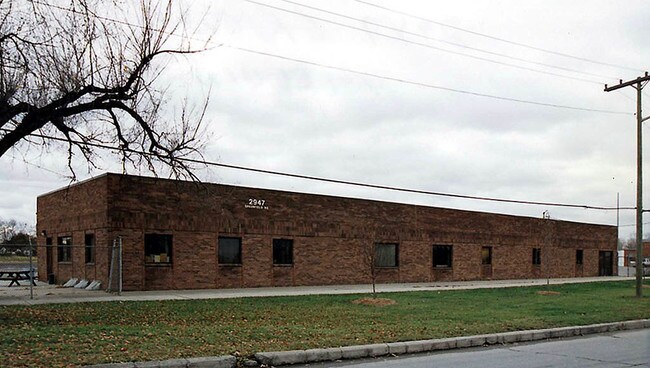
Property Record
2947 Greenfield Rd, Melvindale, MI 48122
NEARBY LISTINGS FOR SALE OR LEASE
Property Detail
2947 Greenfield Rd
Detroit-Warren-Dearborn, MI
Oakwood Dix
47-006-99-0006-000
CJ1 P1A-21 Q181-189 R303-318A PT OF THE OAKWOOD DIX SUB PC 51 L53 P10 WCR AND OF OAKWOOD DIX SUB NO 1 PC 35 661 L48 P17 WCR
Industrialgeneral
Wayne
X
Michigan
26163C0270F
0006
2025
5.38 AC
2025
Downriver North
578500
Detroit
34,862 SF
DEMOGRAPHICS near 2947 Greenfield Rd
1 mile
3 mile
5 mile
2024 Total Population
6,565
98,638
295,496
2029 Population
6,259
95,284
286,099
Pop Growth 2024-2029
(4.66%)
(3.40%)
(3.18%)
Average Age
35
36
37
2024 Total Households
2,288
35,077
105,752
HH Growth 2024-2029
(4.72%)
(3.36%)
(3.16%)
Median Household Inc
$38,586
$43,206
$48,187
Avg Household Size
2.80
2.70
2.70
2024 Avg HH Vehicles
2.00
2.00
2.00
Median Home Value
$102,636
$109,381
$128,899
Median Year Built
1951
1951
1951
Nearby Places
Map Layers
Map Styles
 Street
 Aerial
Transit
 Traffic
 Biking
Places
Listings with unknown addresses are not visible on the map
- Restaurants
- Banks
- Shops
- Fitness
- Groceries
PUBLIC TRANSPORTATION
COMMUTER RAIL
Drive
Walk
Distance
11 min
4.8 mi
Drive
Walk
Distance
15 min
9.2 mi
AIRPORT
Detroit Metro Wayne County
Drive
Walk
Distance
Detroit Metro Wayne County
24 min
15.1 mi
Windsor International
Drive
Walk
Distance
Windsor International
34 min
17.6 mi
Freight Ports
Drive
Walk
Distance
67 min
53.9 mi
Nearby Properties
Address
Land Use
TOTAL SIZE
Lot Size
Zoning
Address
Land Use
TOTAL SIZE
Lot Size
Zoning
830,075 SF
167.21 AC
BC
Address
Land Use
TOTAL SIZE
Lot Size
Zoning
590,116 SF
388.80 AC
ID
Address
Land Use
TOTAL SIZE
Lot Size
Zoning
475,972 SF
42.17 AC
RD
Address
Land Use
TOTAL SIZE
Lot Size
Zoning
1,043,110 SF
35.36 AC
RE
Address
Land Use
TOTAL SIZE
Lot Size
Zoning
229,368 SF
1 AC
C 6A
Address
Land Use
TOTAL SIZE
Lot Size
Zoning
153,040 SF
2.13 AC
BC
Address
Land Use
TOTAL SIZE
Lot Size
Zoning
304,206 SF
29.53 AC
RC
Address
Land Use
TOTAL SIZE
Lot Size
Zoning
2,822,007 SF
75.54 AC
ID
Address
Land Use
TOTAL SIZE
Lot Size
Zoning
357,640 SF
13.89 AC
C 6C
Address
Land Use
TOTAL SIZE
Lot Size
Zoning
135,775 SF
18.39 AC
BC
Address
Land Use
TOTAL SIZE
Lot Size
Zoning
1,076,924 SF
125.54 AC
ID
Address
Land Use
TOTAL SIZE
Lot Size
Zoning
108,960 SF
5.23 AC
OS
Address
Land Use
TOTAL SIZE
Lot Size
Zoning
678,368 SF
48.99 AC
RD RESEARC
Address
Land Use
TOTAL SIZE
Lot Size
Zoning
102,646 SF
77.55 AC
ID
Address
Land Use
TOTAL SIZE
Lot Size
Zoning
198,237 SF
11.07 AC
RE
Address
Land Use
TOTAL SIZE
Lot Size
Zoning
107,772 SF
8 AC
BC
Address
Land Use
TOTAL SIZE
Lot Size
Zoning
32,608 SF
46.51 AC
BC
Address
Land Use
TOTAL SIZE
Lot Size
Zoning
80,861 SF
1.17 AC
BC
Address
Land Use
TOTAL SIZE
Lot Size
Zoning
810,000 SF
23.15 AC
BC
Address
Land Use
TOTAL SIZE
Lot Size
Zoning
77,974 SF
1 AC
C 6A
Address
Land Use
TOTAL SIZE
Lot Size
Zoning
111,008 SF
26.62 AC
IB
Address
Land Use
TOTAL SIZE
Lot Size
Zoning
365,040 SF
382 AC
M4
Address
Land Use
TOTAL SIZE
Lot Size
Zoning
205,632 SF
1 AC
C 6A
Address
Land Use
TOTAL SIZE
Lot Size
Zoning
169,200 SF
19.92 AC
RD RESEARC
Address
Land Use
TOTAL SIZE
Lot Size
Zoning
637,176 SF
39.11 AC
C 6C
Address
Land Use
TOTAL SIZE
Lot Size
Zoning
303,705 SF
17.28 AC
ID
Address
Land Use
TOTAL SIZE
Lot Size
Zoning
196,801 SF
38.32 AC
M5
Address
Land Use
TOTAL SIZE
Lot Size
Zoning
153,668 SF
9.16 AC
RD
Address
Land Use
TOTAL SIZE
Lot Size
Zoning
57,139 SF
35 AC
BC
Address
Land Use
TOTAL SIZE
Lot Size
Zoning
111,402 SF
3.17 AC
The World's #1 Commercial Real Estate Marketplace
Connect with us
© 2026 CoStar Group
The information above has been obtained from sources believed reliable. While we do not doubt its accuracy we have not verified it and make no guarantee, warranty or representation about it. It is your responsibility to independently confirm its accuracy and completeness. Any projections, opinions, assumptions, or estimates used are for example only and do not represent the current or future performance of the property. The value of this transaction to you depends on tax and other factors which should be evaluated by your tax, financial, and legal advisors. You and your advisors should conduct a careful, independent investigation of the property to determine to your satisfaction the suitability of the property for your needs.