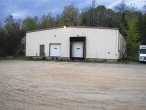
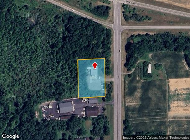
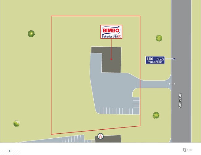
Property Record
2947 Strunk Rd, Fluvanna, NY 14701
NEARBY LISTINGS FOR SALE OR LEASE
Property Detail
2947 Strunk Rd
Jamestown-Dunkirk, NY
17-1-2 17-1-3.3; OLD APN: 063889 17-1-1
063889-369-007-0001-011-000
Chautauqua
Warehouse
New York
2025
11.000
2024
2.01 AC
037300
New York West Area
4,800 SF
Other Market Areas
DEMOGRAPHICS near 2947 Strunk Rd
1 Mile
3 Mile
5 Mile
2024 Total Population
555
23,774
43,287
2029 Population
546
23,372
42,561
Pop Growth 2024-2029
(1.62%)
(1.69%)
(1.68%)
Average Age
45
42
42
2024 Total Households
239
10,585
18,986
HH Growth 2024-2029
(1.67%)
(1.74%)
(1.75%)
Median Household Inc
$43,981
$34,972
$41,146
Avg Household Size
2.30
2.10
2.20
2024 Avg HH Vehicles
2.00
1.00
1.00
Median Home Value
$144,318
$79,466
$79,963
Median Year Built
1958
1948
1949
Nearby Places
Map Layers
Map Styles
 Street
 Aerial
- Restaurants
- Banks
- Shops
- Fitness
- Groceries
SALE & LEASE HISTORY
LISTING DATE
SALE/LEASE

May 05, 2022
For Sale
May 02, 2024
For Sale
Nearby Properties
Address
Land Use
TOTAL SIZE
Lot Size
Zoning
Address
Land Use
TOTAL SIZE
Lot Size
Zoning
Address
Land Use
TOTAL SIZE
Lot Size
Zoning
66,921 SF
98.70 AC
Address
Land Use
TOTAL SIZE
Lot Size
Zoning
130,937 SF
8.60 AC
07 - MIXED
Address
Land Use
TOTAL SIZE
Lot Size
Zoning
Address
Land Use
TOTAL SIZE
Lot Size
Zoning
97,461 SF
1.41 AC
Address
Land Use
TOTAL SIZE
Lot Size
Zoning
68,532 SF
2 AC
Address
Land Use
TOTAL SIZE
Lot Size
Zoning
Address
Land Use
TOTAL SIZE
Lot Size
Zoning
259,898 SF
50.60 AC
Address
Land Use
TOTAL SIZE
Lot Size
Zoning
81,213 SF
1.75 AC
Address
Land Use
TOTAL SIZE
Lot Size
Zoning
Address
Land Use
TOTAL SIZE
Lot Size
Zoning
197,094 SF
25.10 AC
05 - COMME
Address
Land Use
TOTAL SIZE
Lot Size
Zoning
114,938 SF
10.40 AC
02 - SINGL
Address
Land Use
TOTAL SIZE
Lot Size
Zoning
68,967 SF
3.80 AC
05 - COMME
Address
Land Use
TOTAL SIZE
Lot Size
Zoning
106,027 SF
20.60 AC
Address
Land Use
TOTAL SIZE
Lot Size
Zoning
Address
Land Use
TOTAL SIZE
Lot Size
Zoning
82,624 SF
5.70 AC
Address
Land Use
TOTAL SIZE
Lot Size
Zoning
20,512 SF
244.10 AC
08 - GOVER
Address
Land Use
TOTAL SIZE
Lot Size
Zoning
252,460 SF
5.32 AC
Address
Land Use
TOTAL SIZE
Lot Size
Zoning
116,338 SF
15.40 AC
05 - COMME
Address
Land Use
TOTAL SIZE
Lot Size
Zoning
82,116 SF
6.55 AC
05 - COMME
Address
Land Use
TOTAL SIZE
Lot Size
Zoning
92,006 SF
12.30 AC
05 - COMME
Address
Land Use
TOTAL SIZE
Lot Size
Zoning
58,905 SF
1.47 AC
Address
Land Use
TOTAL SIZE
Lot Size
Zoning
85,514 SF
10.80 AC
Address
Land Use
TOTAL SIZE
Lot Size
Zoning
35,850 SF
1.17 AC
Address
Land Use
TOTAL SIZE
Lot Size
Zoning
0.69 AC
Address
Land Use
TOTAL SIZE
Lot Size
Zoning
672,147 SF
48.40 AC
05 - COMME
Address
Land Use
TOTAL SIZE
Lot Size
Zoning
169,236 SF
11.80 AC
06 - INDUS
Address
Land Use
TOTAL SIZE
Lot Size
Zoning
2,484 SF
62.50 AC
04 - FARM
Address
Land Use
TOTAL SIZE
Lot Size
Zoning
63,081 SF
0.88 AC
Address
Land Use
TOTAL SIZE
Lot Size
Zoning
The World's #1 Commercial Real Estate Marketplace
Connect with us
© 2026 CoStar Group
The information above has been obtained from sources believed reliable. While we do not doubt its accuracy we have not verified it and make no guarantee, warranty or representation about it. It is your responsibility to independently confirm its accuracy and completeness. Any projections, opinions, assumptions, or estimates used are for example only and do not represent the current or future performance of the property. The value of this transaction to you depends on tax and other factors which should be evaluated by your tax, financial, and legal advisors. You and your advisors should conduct a careful, independent investigation of the property to determine to your satisfaction the suitability of the property for your needs.