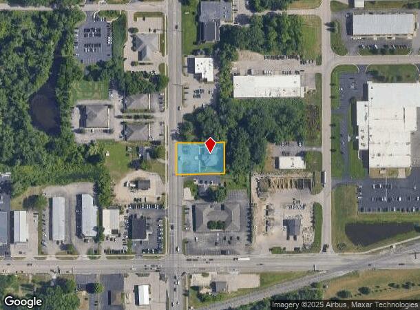
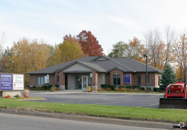
Property Record
295 120Th Ave, Holland, MI 49424

NEARBY LISTINGS FOR SALE OR LEASE
Property Detail
295 120Th Ave
70-16-22-100-058
PART OF NW 1/4 COM N 0D 47M 35S E 383 FT FROM W 1/4 COR, TH N 0D 47M 35S E 130 FT, E 2016 FT S 0D 47M 35S W 130 FT, TH W 2016
Officebuilding
Ottawa
X
Michigan
26005C0040G
0.50 AC
2024
Holland East
2025
West Michigan
022206
Grand Rapids-Wyoming, MI
3,604 SF
DEMOGRAPHICS near 295 120Th Ave
1 Mile
3 Mile
5 Mile
2024 Total Population
1,815
57,120
96,849
2029 Population
1,880
59,675
100,962
Pop Growth 2024-2029
+ 3.58%
+ 4.47%
+ 4.25%
Average Age
38
38
38
2024 Total Households
753
21,073
35,858
HH Growth 2024-2029
+ 3.85%
+ 4.70%
+ 4.38%
Median Household Inc
$38,593
$68,556
$72,655
Avg Household Size
2.40
2.50
2.60
2024 Avg HH Vehicles
2.00
2.00
2.00
Median Home Value
$179,608
$224,492
$235,549
Median Year Built
1981
1983
1984
Nearby Places
Map Layers
Map Styles
 Street
 Aerial
- Restaurants
- Banks
- Shops
- Fitness
- Groceries
PUBLIC TRANSPORTATION
COMMUTER RAIL
DRIVE
WALK
Distance
4 min
1.9 mi
AIRPORT
Gerald R Ford International
DRIVE
WALK
Distance
Gerald R Ford International
43 min
32.5 mi
Nearby Properties
Address
Land Use
TOTAL SIZE
Lot Size
Zoning
Address
Land Use
TOTAL SIZE
Lot Size
Zoning
572,832 SF
10.89 AC
PUD
Address
Land Use
TOTAL SIZE
Lot Size
Zoning
682,378 SF
99.60 AC
NA
Address
Land Use
TOTAL SIZE
Lot Size
Zoning
662,015 SF
177 AC
SEE MAP
Address
Land Use
TOTAL SIZE
Lot Size
Zoning
377,049 SF
24.47 AC
I-2
Address
Land Use
TOTAL SIZE
Lot Size
Zoning
346,440 SF
32.15 AC
PUD
Address
Land Use
TOTAL SIZE
Lot Size
Zoning
362,916 SF
19.23 AC
I-2
Address
Land Use
TOTAL SIZE
Lot Size
Zoning
391,255 SF
40.67 AC
I-2
Address
Land Use
TOTAL SIZE
Lot Size
Zoning
249,051 SF
24.77 AC
LDR
Address
Land Use
TOTAL SIZE
Lot Size
Zoning
3,150 SF
25.40 AC
AG
Address
Land Use
TOTAL SIZE
Lot Size
Zoning
660,002 SF
32.13 AC
I-2
Address
Land Use
TOTAL SIZE
Lot Size
Zoning
218,722 SF
8.59 AC
AGR
Address
Land Use
TOTAL SIZE
Lot Size
Zoning
176,802 SF
17.58 AC
AG
Address
Land Use
TOTAL SIZE
Lot Size
Zoning
320,270 SF
33.25 AC
PUD
Address
Land Use
TOTAL SIZE
Lot Size
Zoning
329,784 SF
38.51 AC
I-2
Address
Land Use
TOTAL SIZE
Lot Size
Zoning
131,497 SF
37.54 AC
I-2
Address
Land Use
TOTAL SIZE
Lot Size
Zoning
226,347 SF
19.44 AC
I-2
Address
Land Use
TOTAL SIZE
Lot Size
Zoning
674,052 SF
79.30 AC
Address
Land Use
TOTAL SIZE
Lot Size
Zoning
83,100 SF
Address
Land Use
TOTAL SIZE
Lot Size
Zoning
132,127 SF
42.69 AC
SEE MAP
Address
Land Use
TOTAL SIZE
Lot Size
Zoning
19.20 AC
AG
Address
Land Use
TOTAL SIZE
Lot Size
Zoning
90,508 SF
I-2
Address
Land Use
TOTAL SIZE
Lot Size
Zoning
210,792 SF
22.91 AC
C-2
Address
Land Use
TOTAL SIZE
Lot Size
Zoning
94,790 SF
1.74 AC
C-2
Address
Land Use
TOTAL SIZE
Lot Size
Zoning
58,710 SF
6.96 AC
C-2
Address
Land Use
TOTAL SIZE
Lot Size
Zoning
209,455 SF
17 AC
C-2
Address
Land Use
TOTAL SIZE
Lot Size
Zoning
Address
Land Use
TOTAL SIZE
Lot Size
Zoning
177,800 SF
12.34 AC
I-2
Address
Land Use
TOTAL SIZE
Lot Size
Zoning
134,490 SF
15.76 AC
C-2
Address
Land Use
TOTAL SIZE
Lot Size
Zoning
149,348 SF
9.22 AC
I-2
Address
Land Use
TOTAL SIZE
Lot Size
Zoning
136,520 SF
13.55 AC
PUD
The World's #1 Commercial Real Estate Marketplace
Connect with us
© 2025 CoStar Group
The information above has been obtained from sources believed reliable. While we do not doubt its accuracy we have not verified it and make no guarantee, warranty or representation about it. It is your responsibility to independently confirm its accuracy and completeness. Any projections, opinions, assumptions, or estimates used are for example only and do not represent the current or future performance of the property. The value of this transaction to you depends on tax and other factors which should be evaluated by your tax, financial, and legal advisors. You and your advisors should conduct a careful, independent investigation of the property to determine to your satisfaction the suitability of the property for your needs.