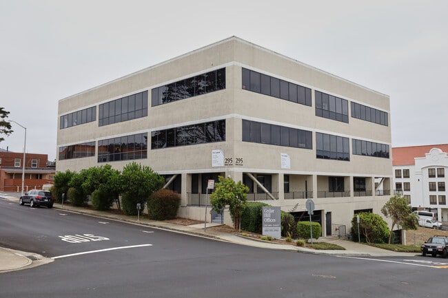
Property Record
295 89Th St, Daly City, CA 94015

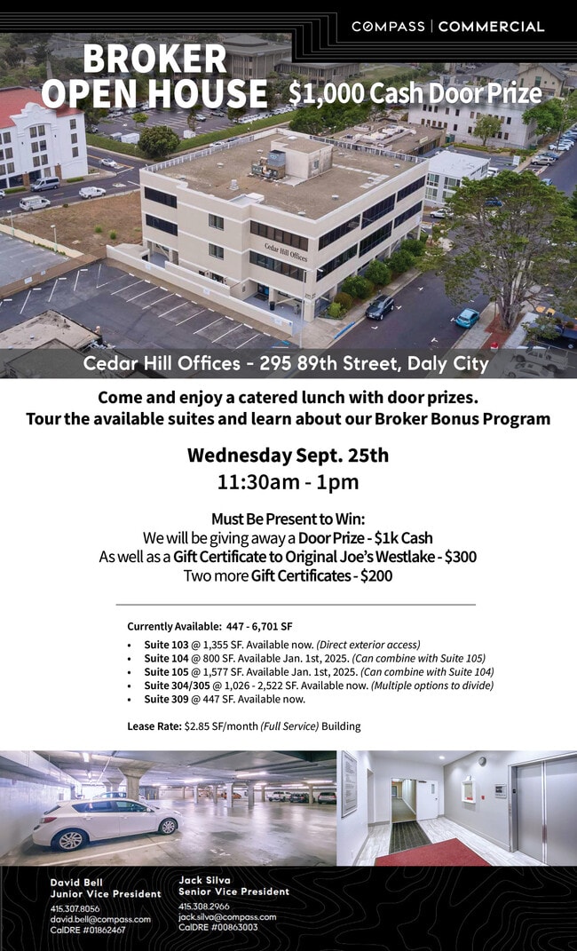
Current Lease Availabilities
Property Detail
295 89Th St
006-206-200
LOTS 20 21 22 23 & ELY 15 FT OF LOT 24 BLK 3 75 DOLLAR LOT HOMESTEAD RSM 1/6
Officebuilding
San Mateo
EA00CO
California
B and X Area of moderate flood hazard, usually the area between the limits of the 100-year and 500-year floods.
20,24
2024
0.26 AC
2025
Brisbane/Daly City
601200
San Francisco
25,985 SF
San Francisco-San Mateo-Redwood City, CA
NEARBY LISTINGS FOR SALE OR LEASE
-
-
-
-
-
-
-
No Photo
-
View all Daly City listings for lease on LoopNet.com
DEMOGRAPHICS near 295 89Th St
1 mile
3 mile
5 mile
2025 Total Population
44,072
211,465
517,775
2030 Population
44,122
210,831
517,701
Pop Growth 2025-2030
+ 0.11%
(0.30%)
(0.01%)
Average Age
41
43
43
2025 Total Households
13,531
66,393
174,700
HH Growth 2025-2030
+ 0.10%
(0.17%)
+ 0.08%
Median Household Inc
$109,882
$121,764
$133,926
Avg Household Size
3.10
3.00
2.80
2025 Avg HH Vehicles
2.00
2.00
2.00
Median Home Value
$1,045,377
$1,061,596
$1,087,688
Median Year Built
1967
1959
1955
Nearby Places
Map Layers
Map Styles
 Street
 Aerial
Layers
 Traffic
 Biking
Places
Listings with unknown addresses are not visible on the map
- Restaurants
- Banks
- Shops
- Fitness
- Groceries
PUBLIC TRANSPORTATION
TRANSIT/SUBWAY
Colma Station (Dublin/Pleasanton - Millbrae - Bay Area Rapid Transit (BART), Pittsburg/Bay Point - San Francisco International - Bay Area Rapid Transit (BART), Richmond - Millbrae - Bay Area Rapid Transit (BART))
Drive
Walk
Distance
Colma Station (Dublin/Pleasanton - Millbrae - Bay Area Rapid Transit (BART), Pittsburg/Bay Point - San Francisco International - Bay Area Rapid Transit (BART), Richmond - Millbrae - Bay Area Rapid Transit (BART))
2 min
13 min
0.7 mi
COMMUTER RAIL
South San Francisco Caltrain Station Northbound (Express - Caltrain (Caltrain), Limited - Caltrain (Caltrain), Local Weekday - Caltrain (Caltrain), Local Weekend - Caltrain (Caltrain))
Drive
Walk
Distance
South San Francisco Caltrain Station Northbound (Express - Caltrain (Caltrain), Limited - Caltrain (Caltrain), Local Weekday - Caltrain (Caltrain), Local Weekend - Caltrain (Caltrain))
11 min
5.9 mi
Bayshore Caltrain Station Southbound (Local Weekday - Caltrain (Caltrain), Local Weekend - Caltrain (Caltrain))
Drive
Walk
Distance
Bayshore Caltrain Station Southbound (Local Weekday - Caltrain (Caltrain), Local Weekend - Caltrain (Caltrain))
11 min
7.5 mi
AIRPORT
San Francisco International
Drive
Walk
Distance
San Francisco International
15 min
9.2 mi
Metro Oakland International
Drive
Walk
Distance
Metro Oakland International
40 min
27.9 mi
Freight Ports
Port of San Francisco
Drive
Walk
Distance
Port of San Francisco
16 min
10.6 mi
Nearby Properties
Address
Land Use
TOTAL SIZE
Lot Size
Zoning
Address
Land Use
TOTAL SIZE
Lot Size
Zoning
411,904 SF
21.74 AC
C2
Address
Land Use
TOTAL SIZE
Lot Size
Zoning
53.85 AC
Address
Land Use
TOTAL SIZE
Lot Size
Zoning
312,191 SF
2.74 AC
Address
Land Use
TOTAL SIZE
Lot Size
Zoning
167,105 SF
2.07 AC
C10000
Address
Land Use
TOTAL SIZE
Lot Size
Zoning
42.95 AC
Address
Land Use
TOTAL SIZE
Lot Size
Zoning
447,674 SF
21.51 AC
Address
Land Use
TOTAL SIZE
Lot Size
Zoning
2.03 AC
C2
Address
Land Use
TOTAL SIZE
Lot Size
Zoning
Address
Land Use
TOTAL SIZE
Lot Size
Zoning
11.31 AC
RM2
Address
Land Use
TOTAL SIZE
Lot Size
Zoning
160,983 SF
1.84 AC
NC2
Address
Land Use
TOTAL SIZE
Lot Size
Zoning
10.62 AC
Address
Land Use
TOTAL SIZE
Lot Size
Zoning
Address
Land Use
TOTAL SIZE
Lot Size
Zoning
187,865 SF
3.54 AC
Address
Land Use
TOTAL SIZE
Lot Size
Zoning
209,692 SF
8.20 AC
R30000
Address
Land Use
TOTAL SIZE
Lot Size
Zoning
2,011 SF
2.49 AC
Address
Land Use
TOTAL SIZE
Lot Size
Zoning
73,491 SF
4.48 AC
C2
Address
Land Use
TOTAL SIZE
Lot Size
Zoning
175,618 SF
2.44 AC
Address
Land Use
TOTAL SIZE
Lot Size
Zoning
12,555 SF
0.74 AC
NCS
Address
Land Use
TOTAL SIZE
Lot Size
Zoning
176,000 SF
1.64 AC
C2
Address
Land Use
TOTAL SIZE
Lot Size
Zoning
54,131 SF
1.75 AC
C2
Address
Land Use
TOTAL SIZE
Lot Size
Zoning
181,172 SF
2.11 AC
Address
Land Use
TOTAL SIZE
Lot Size
Zoning
108,917 SF
4.61 AC
PD0004
Address
Land Use
TOTAL SIZE
Lot Size
Zoning
153,054 SF
15.13 AC
Address
Land Use
TOTAL SIZE
Lot Size
Zoning
141,956 SF
1.74 AC
Address
Land Use
TOTAL SIZE
Lot Size
Zoning
73.91 AC
Address
Land Use
TOTAL SIZE
Lot Size
Zoning
206.09 AC
Address
Land Use
TOTAL SIZE
Lot Size
Zoning
67,432 SF
4.55 AC
CL00C1
Address
Land Use
TOTAL SIZE
Lot Size
Zoning
113,136 SF
9.09 AC
G10000
Address
Land Use
TOTAL SIZE
Lot Size
Zoning
113,782 SF
2.90 AC
Address
Land Use
TOTAL SIZE
Lot Size
Zoning
6.80 AC
RM1
The World's #1 Commercial Real Estate Marketplace
Connect with us
© 2026 CoStar Group
The information above has been obtained from sources believed reliable. While we do not doubt its accuracy we have not verified it and make no guarantee, warranty or representation about it. It is your responsibility to independently confirm its accuracy and completeness. Any projections, opinions, assumptions, or estimates used are for example only and do not represent the current or future performance of the property. The value of this transaction to you depends on tax and other factors which should be evaluated by your tax, financial, and legal advisors. You and your advisors should conduct a careful, independent investigation of the property to determine to your satisfaction the suitability of the property for your needs.