Property Record
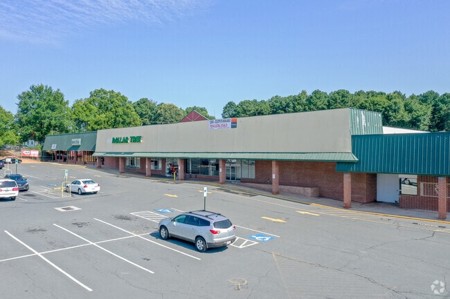
295 E 22Nd St, Kannapolis, NC 28083


Current Lease Availabilities
Property Detail
295 E 22Nd St
161-003
L 1-18 RODGERS PARK SEC 2 & L 6-7,13-16 RODGERS FAIRVIEW
Stripcommercialcenter
Rowan
C2:HIGHWAY
North Carolina
B and X Area of moderate flood hazard, usually the area between the limits of the 100-year and 500-year floods.
4.09 AC
2025
Rowan County
2025
Charlotte
051600
Charlotte-Concord-Gastonia, NC-SC
41,000 SF
NEARBY LISTINGS FOR SALE OR LEASE
-
-
-
-
-
-
-
No Photo
-
View all Kannapolis listings for lease on LoopNet.com
DEMOGRAPHICS near 295 E 22Nd St
1 mile
3 mile
5 mile
2025 Total Population
5,049
38,404
75,355
2030 Population
5,313
40,864
80,127
Pop Growth 2025-2030
+ 5.23%
+ 6.41%
+ 6.33%
Average Age
37
39
40
2025 Total Households
1,930
15,212
29,552
HH Growth 2025-2030
+ 5.39%
+ 6.55%
+ 6.50%
Median Household Inc
$59,730
$58,435
$62,341
Avg Household Size
2.60
2.50
2.50
2025 Avg HH Vehicles
2.00
2.00
2.00
Median Home Value
$270,447
$239,543
$260,530
Median Year Built
1979
1973
1981
Nearby Places
Map Layers
Map Styles
 Street
 Aerial
Layers
 Traffic
 Biking
Places
Listings with unknown addresses are not visible on the map
- Restaurants
- Banks
- Shops
- Fitness
- Groceries
PUBLIC TRANSPORTATION
COMMUTER RAIL
Kannapolis Station (Piedmont - North Carolina by Train (NC Train))
Drive
Walk
Distance
Kannapolis Station (Piedmont - North Carolina by Train (NC Train))
5 min
2.6 mi
AIRPORT
Concord-Padgett Regional
Drive
Walk
Distance
Concord-Padgett Regional
24 min
15.0 mi
Charlotte/Douglas International
Drive
Walk
Distance
Charlotte/Douglas International
49 min
35.2 mi
Freight Ports
Port of Wilmington
Drive
Walk
Distance
Port of Wilmington
264 min
204.2 mi
Nearby Properties
Address
Land Use
TOTAL SIZE
Lot Size
Zoning
Address
Land Use
TOTAL SIZE
Lot Size
Zoning
276,070 SF
CC
Address
Land Use
TOTAL SIZE
Lot Size
Zoning
728,000 SF
51.80 AC
Address
Land Use
TOTAL SIZE
Lot Size
Zoning
128,064 SF
2.68 AC
CC
Address
Land Use
TOTAL SIZE
Lot Size
Zoning
121,156 SF
3.57 AC
CC
Address
Land Use
TOTAL SIZE
Lot Size
Zoning
106,804 SF
1.81 AC
CC
Address
Land Use
TOTAL SIZE
Lot Size
Zoning
83,152 SF
7.11 AC
CC
Address
Land Use
TOTAL SIZE
Lot Size
Zoning
176,075 SF
2.35 AC
CC
Address
Land Use
TOTAL SIZE
Lot Size
Zoning
297,600 SF
16.28 AC
Address
Land Use
TOTAL SIZE
Lot Size
Zoning
279,000 SF
23.48 AC
Address
Land Use
TOTAL SIZE
Lot Size
Zoning
5,308 SF
15.16 AC
RC
Address
Land Use
TOTAL SIZE
Lot Size
Zoning
85,422 SF
6.30 AC
R8
Address
Land Use
TOTAL SIZE
Lot Size
Zoning
67,862 SF
1.77 AC
CC
Address
Land Use
TOTAL SIZE
Lot Size
Zoning
12,010 SF
0.40 AC
CC
Address
Land Use
TOTAL SIZE
Lot Size
Zoning
66,194 SF
2.94 AC
CC
Address
Land Use
TOTAL SIZE
Lot Size
Zoning
101,014 SF
1.84 AC
CC
Address
Land Use
TOTAL SIZE
Lot Size
Zoning
56,923 SF
2 AC
CC
Address
Land Use
TOTAL SIZE
Lot Size
Zoning
33,728 SF
14.29 AC
GC
Address
Land Use
TOTAL SIZE
Lot Size
Zoning
128,280 SF
10.82 AC
Address
Land Use
TOTAL SIZE
Lot Size
Zoning
68,257 SF
8.26 AC
R8
Address
Land Use
TOTAL SIZE
Lot Size
Zoning
64,554 SF
2.67 AC
CC
Address
Land Use
TOTAL SIZE
Lot Size
Zoning
115,509 SF
4.90 AC
R8
Address
Land Use
TOTAL SIZE
Lot Size
Zoning
12,415 SF
25.46 AC
R8
Address
Land Use
TOTAL SIZE
Lot Size
Zoning
269,700 SF
76.24 AC
Address
Land Use
TOTAL SIZE
Lot Size
Zoning
78,771 SF
CC
Address
Land Use
TOTAL SIZE
Lot Size
Zoning
50,366 SF
1.64 AC
CC
Address
Land Use
TOTAL SIZE
Lot Size
Zoning
175,140 SF
1.12 AC
CC
Address
Land Use
TOTAL SIZE
Lot Size
Zoning
35,850 SF
34 AC
Address
Land Use
TOTAL SIZE
Lot Size
Zoning
15,141 SF
22.29 AC
R4
Address
Land Use
TOTAL SIZE
Lot Size
Zoning
48,024 SF
5.26 AC
O-I
Address
Land Use
TOTAL SIZE
Lot Size
Zoning
1,545 SF
0.56 AC
CC
The World's #1 Commercial Real Estate Marketplace
Connect with us
© 2026 CoStar Group
The information above has been obtained from sources believed reliable. While we do not doubt its accuracy we have not verified it and make no guarantee, warranty or representation about it. It is your responsibility to independently confirm its accuracy and completeness. Any projections, opinions, assumptions, or estimates used are for example only and do not represent the current or future performance of the property. The value of this transaction to you depends on tax and other factors which should be evaluated by your tax, financial, and legal advisors. You and your advisors should conduct a careful, independent investigation of the property to determine to your satisfaction the suitability of the property for your needs.