Property Record
295 Grant Cliff Rd, Zanesville, OH 43701


NEARBY LISTINGS FOR SALE OR LEASE
-
-
View all Zanesville listings for lease on LoopNet.com
Property Detail
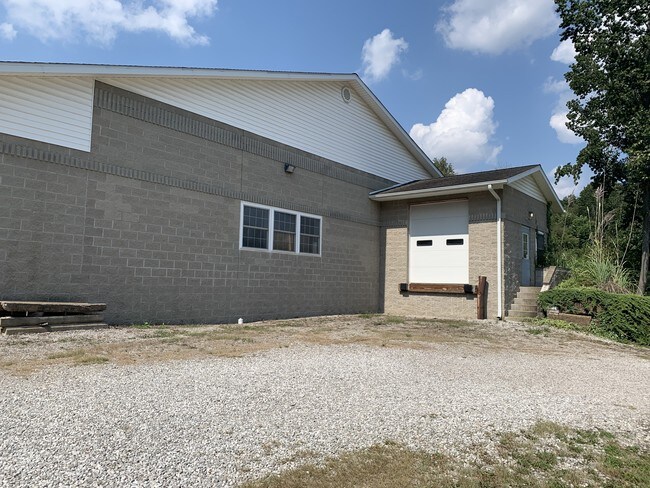
295 Grant Cliff Rd
62-78-06-21-005
R 13 TP 11 SEC 5 1.027A
Warehouse
Muskingum
X
Ohio
39119C0294G
1.03 AC
2024
Ohio South Area
2024
Other Market Areas
912300
Zanesville, OH
9,808 SF
DEMOGRAPHICS near 295 Grant Cliff Rd
1 Mile
3 Mile
5 Mile
2024 Total Population
2,660
20,020
37,643
2029 Population
2,673
20,228
37,905
Pop Growth 2024-2029
+ 0.49%
+ 1.04%
+ 0.70%
Average Age
43
39
40
2024 Total Households
1,141
8,187
15,366
HH Growth 2024-2029
+ 0.53%
+ 1.00%
+ 0.66%
Median Household Inc
$52,573
$38,540
$41,765
Avg Household Size
2.30
2.40
2.30
2024 Avg HH Vehicles
2.00
2.00
2.00
Median Home Value
$108,842
$88,482
$105,611
Median Year Built
1972
1956
1956
Nearby Places
Map Layers
Map Styles
 Street
 Aerial
- Restaurants
- Banks
- Shops
- Fitness
- Groceries
SALE & LEASE HISTORY
LISTING DATE
SALE/LEASE

Sep 24, 2019
For Sale
Mar 13, 2020
For Lease
Jun 16, 2017
For Sale
Nearby Properties
Address
Land Use
TOTAL SIZE
Lot Size
Zoning
Address
Land Use
TOTAL SIZE
Lot Size
Zoning
12,480 SF
43.22 AC
Address
Land Use
TOTAL SIZE
Lot Size
Zoning
74,956 SF
10.45 AC
RS5
Address
Land Use
TOTAL SIZE
Lot Size
Zoning
150,499 SF
29.64 AC
Address
Land Use
TOTAL SIZE
Lot Size
Zoning
6,344 SF
19.56 AC
Address
Land Use
TOTAL SIZE
Lot Size
Zoning
184,623 SF
21.08 AC
Address
Land Use
TOTAL SIZE
Lot Size
Zoning
17,723 SF
0.94 AC
C4
Address
Land Use
TOTAL SIZE
Lot Size
Zoning
2,772 SF
4.72 AC
RM1
Address
Land Use
TOTAL SIZE
Lot Size
Zoning
6,662 SF
13.02 AC
I1
Address
Land Use
TOTAL SIZE
Lot Size
Zoning
61,732 SF
18.46 AC
Address
Land Use
TOTAL SIZE
Lot Size
Zoning
23,857 SF
0.14 AC
C4
Address
Land Use
TOTAL SIZE
Lot Size
Zoning
54,300 SF
7.47 AC
Address
Land Use
TOTAL SIZE
Lot Size
Zoning
3.37 AC
I1
Address
Land Use
TOTAL SIZE
Lot Size
Zoning
5,404 SF
15.25 AC
RM1
Address
Land Use
TOTAL SIZE
Lot Size
Zoning
12,720 SF
5.24 AC
Address
Land Use
TOTAL SIZE
Lot Size
Zoning
30,836 SF
0.12 AC
C4
Address
Land Use
TOTAL SIZE
Lot Size
Zoning
16,109 SF
3.75 AC
Address
Land Use
TOTAL SIZE
Lot Size
Zoning
40,064 SF
6.55 AC
Address
Land Use
TOTAL SIZE
Lot Size
Zoning
3,400 SF
0.82 AC
C4
Address
Land Use
TOTAL SIZE
Lot Size
Zoning
96,273 SF
6.41 AC
Address
Land Use
TOTAL SIZE
Lot Size
Zoning
960 SF
20.25 AC
I1
Address
Land Use
TOTAL SIZE
Lot Size
Zoning
38,732 SF
0.11 AC
RS5
Address
Land Use
TOTAL SIZE
Lot Size
Zoning
6,877 SF
12.18 AC
RM1
Address
Land Use
TOTAL SIZE
Lot Size
Zoning
60,453 SF
4.65 AC
RS5
Address
Land Use
TOTAL SIZE
Lot Size
Zoning
32,980 SF
12.81 AC
RES
Address
Land Use
TOTAL SIZE
Lot Size
Zoning
12,160 SF
1.70 AC
RS5
Address
Land Use
TOTAL SIZE
Lot Size
Zoning
14,295 SF
5.40 AC
Address
Land Use
TOTAL SIZE
Lot Size
Zoning
32,204 SF
1.15 AC
Address
Land Use
TOTAL SIZE
Lot Size
Zoning
15,056 SF
4 AC
Address
Land Use
TOTAL SIZE
Lot Size
Zoning
71,070 SF
7.31 AC
Address
Land Use
TOTAL SIZE
Lot Size
Zoning
12.45 AC
The World's #1 Commercial Real Estate Marketplace
Connect with us
© 2026 CoStar Group
The information above has been obtained from sources believed reliable. While we do not doubt its accuracy we have not verified it and make no guarantee, warranty or representation about it. It is your responsibility to independently confirm its accuracy and completeness. Any projections, opinions, assumptions, or estimates used are for example only and do not represent the current or future performance of the property. The value of this transaction to you depends on tax and other factors which should be evaluated by your tax, financial, and legal advisors. You and your advisors should conduct a careful, independent investigation of the property to determine to your satisfaction the suitability of the property for your needs.