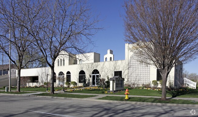
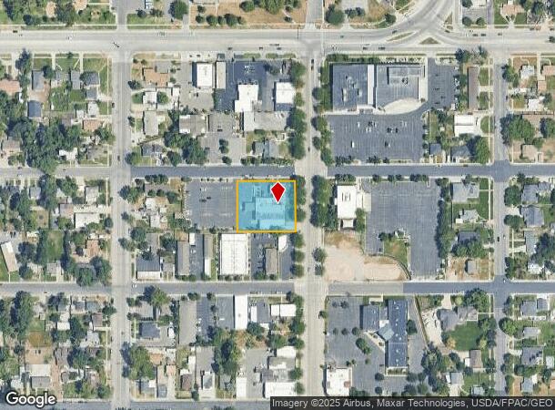
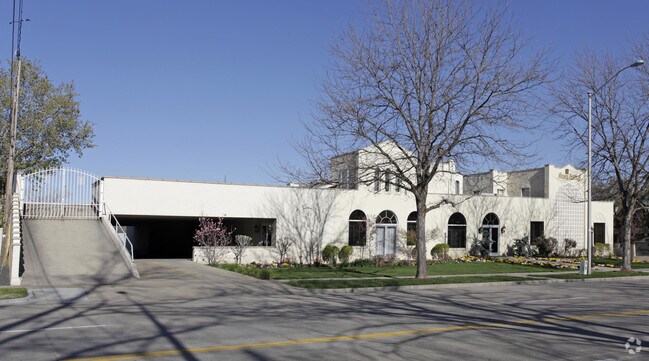
Property Record
295 N Main St, Bountiful, UT 84010
NEARBY LISTINGS FOR SALE OR LEASE
Property Detail
295 N Main St
03-026-0063
BEG NE CORNER OF LOT 4, BLK 44, PLAT A, BOUNTIFUL TS SURVEY, W 188 FT, S 60 FT, E 188 FT, N 60 FT TO BEG. CONT. 0.263 ACRES. BEG 60 FT S OF NE CORNER OF LOT 4, BLK 44, PLAT A, BOUNTIFUL TS SURV
Parkingstructure
Davis
X
Utah
49011C0394F
4
2025
0.71 AC
2025
Davis/Weber Counties
126700
Salt Lake City
7,878 SF
Ogden-Clearfield, UT
DEMOGRAPHICS near 295 N Main St
1 Mile
3 Mile
5 Mile
2024 Total Population
15,514
72,510
105,036
2029 Population
16,317
76,114
110,535
Pop Growth 2024-2029
+ 5.18%
+ 4.97%
+ 5.24%
Average Age
37
37
37
2024 Total Households
5,737
24,235
34,436
HH Growth 2024-2029
+ 5.25%
+ 5.04%
+ 5.31%
Median Household Inc
$69,598
$93,796
$97,060
Avg Household Size
2.60
3.00
3.00
2024 Avg HH Vehicles
2.00
2.00
2.00
Median Home Value
$397,460
$451,910
$463,713
Median Year Built
1970
1977
1983
Nearby Places
Map Layers
Map Styles
 Street
 Aerial
- Restaurants
- Banks
- Shops
- Fitness
- Groceries
PUBLIC TRANSPORTATION
COMMUTER RAIL
Woods Cross (FrontRunner North - Utah Transit Authority (UTA))
DRIVE
WALK
Distance
Woods Cross (FrontRunner North - Utah Transit Authority (UTA))
4 min
1.9 mi
Farmington (FrontRunner North - Utah Transit Authority (UTA))
DRIVE
WALK
Distance
Farmington (FrontRunner North - Utah Transit Authority (UTA))
11 min
7.9 mi
AIRPORT
Salt Lake City International
DRIVE
WALK
Distance
Salt Lake City International
20 min
14.2 mi
Freight Ports
Port of Stockton
DRIVE
WALK
Distance
Port of Stockton
720 min
704.5 mi
Nearby Properties
Address
Land Use
TOTAL SIZE
Lot Size
Zoning
Address
Land Use
TOTAL SIZE
Lot Size
Zoning
123,416 SF
14.85 AC
R4
Address
Land Use
TOTAL SIZE
Lot Size
Zoning
181,804 SF
24.72 AC
Address
Land Use
TOTAL SIZE
Lot Size
Zoning
83,092 SF
9.07 AC
R3
Address
Land Use
TOTAL SIZE
Lot Size
Zoning
240,104 SF
37.03 AC
C2
Address
Land Use
TOTAL SIZE
Lot Size
Zoning
168,369 SF
10.14 AC
H
Address
Land Use
TOTAL SIZE
Lot Size
Zoning
113,419 SF
16.45 AC
R4
Address
Land Use
TOTAL SIZE
Lot Size
Zoning
92,796 SF
2.22 AC
DN
Address
Land Use
TOTAL SIZE
Lot Size
Zoning
67,712 SF
4.98 AC
CVH
Address
Land Use
TOTAL SIZE
Lot Size
Zoning
219,598 SF
19.99 AC
CVH
Address
Land Use
TOTAL SIZE
Lot Size
Zoning
113,265 SF
0.55 AC
CG
Address
Land Use
TOTAL SIZE
Lot Size
Zoning
45,956 SF
8.44 AC
Address
Land Use
TOTAL SIZE
Lot Size
Zoning
156,694 SF
7.67 AC
Address
Land Use
TOTAL SIZE
Lot Size
Zoning
167,410 SF
12.89 AC
CG
Address
Land Use
TOTAL SIZE
Lot Size
Zoning
155,896 SF
8.96 AC
Address
Land Use
TOTAL SIZE
Lot Size
Zoning
58,273 SF
3.80 AC
I1
Address
Land Use
TOTAL SIZE
Lot Size
Zoning
532 SF
144.31 AC
A1
Address
Land Use
TOTAL SIZE
Lot Size
Zoning
280,221 SF
30.36 AC
R4
Address
Land Use
TOTAL SIZE
Lot Size
Zoning
167,405 SF
13.81 AC
CVH
Address
Land Use
TOTAL SIZE
Lot Size
Zoning
19,299 SF
3.06 AC
Address
Land Use
TOTAL SIZE
Lot Size
Zoning
3,986 SF
13 AC
CG
Address
Land Use
TOTAL SIZE
Lot Size
Zoning
119,710 SF
13.15 AC
R4
Address
Land Use
TOTAL SIZE
Lot Size
Zoning
6,050 SF
59.94 AC
Address
Land Use
TOTAL SIZE
Lot Size
Zoning
90,104 SF
9.62 AC
CVH
Address
Land Use
TOTAL SIZE
Lot Size
Zoning
66,855 SF
5.84 AC
CVH
Address
Land Use
TOTAL SIZE
Lot Size
Zoning
81,147 SF
4.10 AC
CVH
Address
Land Use
TOTAL SIZE
Lot Size
Zoning
146,381 SF
18.50 AC
PFL
Address
Land Use
TOTAL SIZE
Lot Size
Zoning
72,560 SF
2.32 AC
Address
Land Use
TOTAL SIZE
Lot Size
Zoning
101,110 SF
8.12 AC
Address
Land Use
TOTAL SIZE
Lot Size
Zoning
9,747 SF
7.73 AC
R4
Address
Land Use
TOTAL SIZE
Lot Size
Zoning
37,334 SF
9.72 AC
RM19
The World's #1 Commercial Real Estate Marketplace
Connect with us
© 2025 CoStar Group
The information above has been obtained from sources believed reliable. While we do not doubt its accuracy we have not verified it and make no guarantee, warranty or representation about it. It is your responsibility to independently confirm its accuracy and completeness. Any projections, opinions, assumptions, or estimates used are for example only and do not represent the current or future performance of the property. The value of this transaction to you depends on tax and other factors which should be evaluated by your tax, financial, and legal advisors. You and your advisors should conduct a careful, independent investigation of the property to determine to your satisfaction the suitability of the property for your needs.