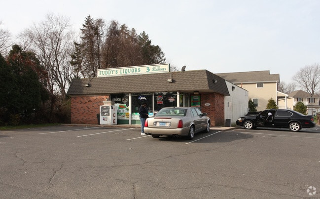
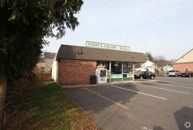
Property Record
295 Windsor Ave, Windsor, CT 06095

Property Detail
295 Windsor Ave
WIND-000069-000450-000006
Capitol
Commercialbuilding
Connecticut
B and X Area of moderate flood hazard, usually the area between the limits of the 100-year and 500-year floods.
6
2024
0.42 AC
2025
Windsor
473800
Hartford
1,882 SF
Hartford-West Hartford-East Hartford, CT
NEARBY LISTINGS FOR SALE OR LEASE
DEMOGRAPHICS near 295 Windsor Ave
1 mile
3 mile
5 mile
2025 Total Population
4,177
70,541
200,185
2030 Population
4,203
71,543
204,014
Pop Growth 2025-2030
+ 0.62%
+ 1.42%
+ 1.91%
Average Age
41
39
39
2025 Total Households
1,602
25,576
80,312
HH Growth 2025-2030
+ 0.56%
+ 1.39%
+ 2.05%
Median Household Inc
$73,652
$57,943
$60,454
Avg Household Size
2.50
2.50
2.30
2025 Avg HH Vehicles
2.00
1.00
1.00
Median Home Value
$242,260
$245,032
$279,039
Median Year Built
1953
1957
1959
Nearby Places
Map Layers
Map Styles
 Street
 Aerial
Transit
 Traffic
 Biking
Places
Listings with unknown addresses are not visible on the map
- Restaurants
- Banks
- Shops
- Fitness
- Groceries
PUBLIC TRANSPORTATION
COMMUTER RAIL
Drive
Walk
Distance
8 min
3.2 mi
Drive
Walk
Distance
7 min
3.4 mi
AIRPORT
Bradley International
Drive
Walk
Distance
Bradley International
28 min
14.0 mi
Nearby Properties
Address
Land Use
TOTAL SIZE
Lot Size
Zoning
Address
Land Use
TOTAL SIZE
Lot Size
Zoning
13,680 SF
240.83 AC
Address
Land Use
TOTAL SIZE
Lot Size
Zoning
213,017 SF
6.21 AC
DT-3
Address
Land Use
TOTAL SIZE
Lot Size
Zoning
584 AC
OS
Address
Land Use
TOTAL SIZE
Lot Size
Zoning
7.45 AC
CAMP
Address
Land Use
TOTAL SIZE
Lot Size
Zoning
14.56 AC
SDD/BG
Address
Land Use
TOTAL SIZE
Lot Size
Zoning
310,901 SF
28.75 AC
MX-2
Address
Land Use
TOTAL SIZE
Lot Size
Zoning
40,632 SF
1.10 AC
NX-1
Address
Land Use
TOTAL SIZE
Lot Size
Zoning
11.85 AC
MX-2
Address
Land Use
TOTAL SIZE
Lot Size
Zoning
172,026 SF
11.64 AC
MX-2
Address
Land Use
TOTAL SIZE
Lot Size
Zoning
10.74 AC
ID-1
Address
Land Use
TOTAL SIZE
Lot Size
Zoning
319,127 SF
2.51 AC
DT-3
Address
Land Use
TOTAL SIZE
Lot Size
Zoning
23.07 AC
CAMP
Address
Land Use
TOTAL SIZE
Lot Size
Zoning
132,110 SF
1 AC
I
Address
Land Use
TOTAL SIZE
Lot Size
Zoning
43,711 SF
1 AC
I
Address
Land Use
TOTAL SIZE
Lot Size
Zoning
82,938 SF
62.53 AC
I-1
Address
Land Use
TOTAL SIZE
Lot Size
Zoning
Address
Land Use
TOTAL SIZE
Lot Size
Zoning
23.99 AC
ID-1
Address
Land Use
TOTAL SIZE
Lot Size
Zoning
6.50 AC
Address
Land Use
TOTAL SIZE
Lot Size
Zoning
421,152 SF
45.95 AC
CD
Address
Land Use
TOTAL SIZE
Lot Size
Zoning
356,062 SF
23.10 AC
ID-2
Address
Land Use
TOTAL SIZE
Lot Size
Zoning
35.05 AC
FP
Address
Land Use
TOTAL SIZE
Lot Size
Zoning
66.09 AC
CX-2
Address
Land Use
TOTAL SIZE
Lot Size
Zoning
732,135 SF
2.20 AC
DT-1
Address
Land Use
TOTAL SIZE
Lot Size
Zoning
6.61 AC
B-4
Address
Land Use
TOTAL SIZE
Lot Size
Zoning
122,329 SF
4.49 AC
MX-2
Address
Land Use
TOTAL SIZE
Lot Size
Zoning
109,206 SF
4.27 AC
MX-2
Address
Land Use
TOTAL SIZE
Lot Size
Zoning
121,984 SF
16.35 AC
MX-2
Address
Land Use
TOTAL SIZE
Lot Size
Zoning
177,630 SF
32.64 AC
Address
Land Use
TOTAL SIZE
Lot Size
Zoning
247,428 SF
35.46 AC
Address
Land Use
TOTAL SIZE
Lot Size
Zoning
57,140 SF
1 AC
I
The World's #1 Commercial Real Estate Marketplace
Connect with us
© 2026 CoStar Group
The information above has been obtained from sources believed reliable. While we do not doubt its accuracy we have not verified it and make no guarantee, warranty or representation about it. It is your responsibility to independently confirm its accuracy and completeness. Any projections, opinions, assumptions, or estimates used are for example only and do not represent the current or future performance of the property. The value of this transaction to you depends on tax and other factors which should be evaluated by your tax, financial, and legal advisors. You and your advisors should conduct a careful, independent investigation of the property to determine to your satisfaction the suitability of the property for your needs.