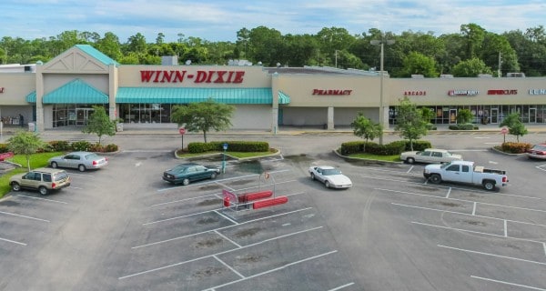
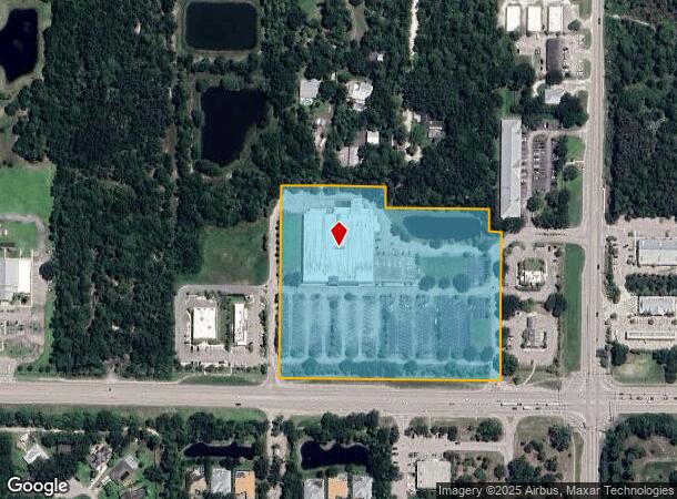
Property Record
2950 9Th Southwest St Sw, Vero Beach, FL 32968
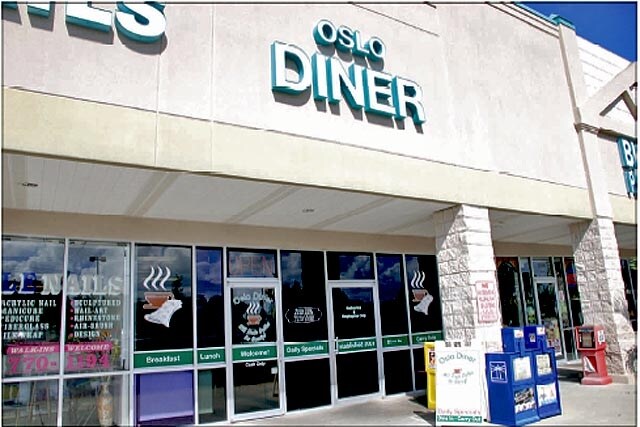

Current Lease Availabilities
NEARBY LISTINGS FOR SALE OR LEASE
Property Detail
2950 9Th Southwest St Sw
33-39-22-00001-0160-00008.0
Indian River Farms Company S/D
Regionalshoppingcenterormallwithanchorstore
INDIAN RIVER FARMS COMPANY S/D PBS 2 - 25 SEC 22 TWP 33 RNG 39 TR 16 MORE FULLY DESC AS A PORT OF TR 16 COMM AT SE COR TR 16; TH RUN N00-20-52E ALONG E LINE OF THE SE QUARTER OF SAID SEC 22 A DIST OF 130.00 FT TO N ROW LINE OF CR 606 PER PLAT OF SPEC
X
Indian River
12061C0358H
Florida
2025
8.94 AC
2025
Fort Pierce/Port St Lucie
050706
Other Market Areas
61,164 SF
Sebastian-Vero Beach, FL
DEMOGRAPHICS near 2950 9Th Southwest St Sw
1 Mile
3 Mile
5 Mile
2024 Total Population
6,728
49,734
93,720
2029 Population
7,404
55,368
106,155
Pop Growth 2024-2029
+ 10.05%
+ 11.33%
+ 13.27%
Average Age
41
46
48
2024 Total Households
2,430
20,472
41,422
HH Growth 2024-2029
+ 9.26%
+ 11.01%
+ 13.04%
Median Household Inc
$56,986
$59,645
$56,010
Avg Household Size
2.60
2.30
2.20
2024 Avg HH Vehicles
2.00
2.00
2.00
Median Home Value
$254,289
$229,320
$235,317
Median Year Built
2000
1988
1986
Nearby Places
- Restaurants
- Banks
- Shops
- Fitness
- Groceries
Nearby Properties
Address
Land Use
TOTAL SIZE
Lot Size
Zoning
Address
Land Use
TOTAL SIZE
Lot Size
Zoning
302,878 SF
40 AC
INST
Address
Land Use
TOTAL SIZE
Lot Size
Zoning
10,600 SF
36.80 AC
RS-6
Address
Land Use
TOTAL SIZE
Lot Size
Zoning
12,192 SF
40 AC
RS-6
Address
Land Use
TOTAL SIZE
Lot Size
Zoning
231,651 SF
16.23 AC
RM-10
Address
Land Use
TOTAL SIZE
Lot Size
Zoning
165,453 SF
29.42 AC
RM-6
Address
Land Use
TOTAL SIZE
Lot Size
Zoning
150,160 SF
13.12 AC
PD
Address
Land Use
TOTAL SIZE
Lot Size
Zoning
168,782 SF
17.84 AC
CG
Address
Land Use
TOTAL SIZE
Lot Size
Zoning
9,312 SF
73.67 AC
RS-6
Address
Land Use
TOTAL SIZE
Lot Size
Zoning
85,023 SF
16.44 AC
CG
Address
Land Use
TOTAL SIZE
Lot Size
Zoning
2,064 SF
21.45 AC
CL
Address
Land Use
TOTAL SIZE
Lot Size
Zoning
5,086 SF
19.65 AC
RS-6
Address
Land Use
TOTAL SIZE
Lot Size
Zoning
72,122 SF
18.30 AC
RS-3
Address
Land Use
TOTAL SIZE
Lot Size
Zoning
42,625 SF
17.40 AC
RS-3
Address
Land Use
TOTAL SIZE
Lot Size
Zoning
19,059 SF
8.35 AC
CG
Address
Land Use
TOTAL SIZE
Lot Size
Zoning
122,038 SF
10.02 AC
RM-10
Address
Land Use
TOTAL SIZE
Lot Size
Zoning
68,600 SF
7.41 AC
RM-8
Address
Land Use
TOTAL SIZE
Lot Size
Zoning
12,082 SF
4.28 AC
CG
Address
Land Use
TOTAL SIZE
Lot Size
Zoning
60,490 SF
14.92 AC
RS-6
Address
Land Use
TOTAL SIZE
Lot Size
Zoning
71,201 SF
3.29 AC
CH
Address
Land Use
TOTAL SIZE
Lot Size
Zoning
29 AC
MED
Address
Land Use
TOTAL SIZE
Lot Size
Zoning
416 SF
5.34 AC
CH
Address
Land Use
TOTAL SIZE
Lot Size
Zoning
6,191 SF
2.71 AC
CH
Address
Land Use
TOTAL SIZE
Lot Size
Zoning
1,300 SF
5.41 AC
IL
Address
Land Use
TOTAL SIZE
Lot Size
Zoning
600 SF
6.49 AC
CH
Address
Land Use
TOTAL SIZE
Lot Size
Zoning
9,792 SF
4.13 AC
CG
Address
Land Use
TOTAL SIZE
Lot Size
Zoning
50,400 SF
18.98 AC
RS-6
Address
Land Use
TOTAL SIZE
Lot Size
Zoning
416 SF
5.72 AC
CH
Address
Land Use
TOTAL SIZE
Lot Size
Zoning
2,830 SF
37.05 AC
RS-6
Address
Land Use
TOTAL SIZE
Lot Size
Zoning
924 SF
9.55 AC
RM-10
The World's #1 Commercial Real Estate Marketplace
Connect with us
© 2025 CoStar Group
The information above has been obtained from sources believed reliable. While we do not doubt its accuracy we have not verified it and make no guarantee, warranty or representation about it. It is your responsibility to independently confirm its accuracy and completeness. Any projections, opinions, assumptions, or estimates used are for example only and do not represent the current or future performance of the property. The value of this transaction to you depends on tax and other factors which should be evaluated by your tax, financial, and legal advisors. You and your advisors should conduct a careful, independent investigation of the property to determine to your satisfaction the suitability of the property for your needs.