Property Record
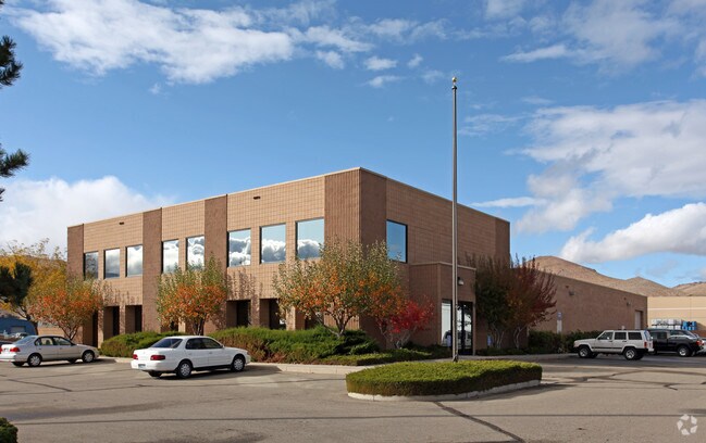
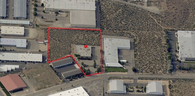
2950 Arrowhead Dr, Carson City, NV 89706


Property Detail
2950 Arrowhead Dr
005-071-02
INDUSTRIAL AIR PARK LOT 18
Lightindustrial
Carson City
GIA
Nevada
AH Areas with a 1% annual chance of shallow flooding, usually in the form of a pond, withan average depth ranging from 1 to 3 feet. These areas have a 26% chance of flooding over the life of a 30-year mortgage.
18
2025
4.36 AC
2025
Carson City County
000400
Reno/Sparks
16,752 SF
Carson City, NV
NEARBY LISTINGS FOR SALE OR LEASE
DEMOGRAPHICS near 2950 Arrowhead Dr
1 mile
3 mile
5 mile
2025 Total Population
1,190
33,799
54,467
2030 Population
1,170
33,710
54,301
Pop Growth 2025-2030
(1.68%)
(0.26%)
(0.30%)
Average Age
48
42
43
2025 Total Households
503
13,936
22,332
HH Growth 2025-2030
(1.99%)
(0.43%)
(0.35%)
Median Household Inc
$70,740
$66,262
$69,849
Avg Household Size
2.30
2.40
2.30
2025 Avg HH Vehicles
2.00
2.00
2.00
Median Home Value
$239,361
$412,116
$436,977
Median Year Built
1979
1980
1981
Nearby Places
Map Layers
Map Styles
 Street
 Aerial
Transit
 Traffic
 Biking
Places
Listings with unknown addresses are not visible on the map
- Restaurants
- Banks
- Shops
- Fitness
- Groceries
PUBLIC TRANSPORTATION
AIRPORT
Reno/Tahoe International
Drive
Walk
Distance
Reno/Tahoe International
53 min
31.6 mi
SALE & LEASE HISTORY
LISTING DATE
SALE/LEASE

Sep 24, 2024
For Sale
Feb 02, 2021
For Sale
Aug 21, 2017
For Sale
Nearby Properties
Address
Land Use
TOTAL SIZE
Lot Size
Zoning
Address
Land Use
TOTAL SIZE
Lot Size
Zoning
383,670 SF
31.92 AC
RC
Address
Land Use
TOTAL SIZE
Lot Size
Zoning
356,776 SF
64.42 AC
P
Address
Land Use
TOTAL SIZE
Lot Size
Zoning
175,233 SF
5.88 AC
PR
Address
Land Use
TOTAL SIZE
Lot Size
Zoning
7,419 SF
0.71 AC
PR
Address
Land Use
TOTAL SIZE
Lot Size
Zoning
272,519 SF
102.35 AC
P
Address
Land Use
TOTAL SIZE
Lot Size
Zoning
92,560 SF
4.93 AC
MFA
Address
Land Use
TOTAL SIZE
Lot Size
Zoning
96,057 SF
10 AC
LI
Address
Land Use
TOTAL SIZE
Lot Size
Zoning
213,246 SF
19.48 AC
GC-RC
Address
Land Use
TOTAL SIZE
Lot Size
Zoning
240 AC
PR
Address
Land Use
TOTAL SIZE
Lot Size
Zoning
157,914 SF
7.15 AC
PR
Address
Land Use
TOTAL SIZE
Lot Size
Zoning
137,022 SF
5.29 AC
RC
Address
Land Use
TOTAL SIZE
Lot Size
Zoning
109,200 SF
9.35 AC
GC
Address
Land Use
TOTAL SIZE
Lot Size
Zoning
169,086 SF
18.49 AC
RC-P
Address
Land Use
TOTAL SIZE
Lot Size
Zoning
29.98 AC
PC
Address
Land Use
TOTAL SIZE
Lot Size
Zoning
178.40 AC
PR
Address
Land Use
TOTAL SIZE
Lot Size
Zoning
75,863 SF
3.92 AC
RC
Address
Land Use
TOTAL SIZE
Lot Size
Zoning
111,950 SF
18.20 AC
RC-MHP
Address
Land Use
TOTAL SIZE
Lot Size
Zoning
113,007 SF
52.90 AC
PR
Address
Land Use
TOTAL SIZE
Lot Size
Zoning
156,408 SF
2.08 AC
MFA-GC
Address
Land Use
TOTAL SIZE
Lot Size
Zoning
160,769 SF
15 AC
LI
Address
Land Use
TOTAL SIZE
Lot Size
Zoning
86,783 SF
52 AC
PR
Address
Land Use
TOTAL SIZE
Lot Size
Zoning
21.67 AC
RC-P
Address
Land Use
TOTAL SIZE
Lot Size
Zoning
20,800 SF
2.90 AC
GC
Address
Land Use
TOTAL SIZE
Lot Size
Zoning
68,342 SF
2.47 AC
TC
Address
Land Use
TOTAL SIZE
Lot Size
Zoning
256.42 AC
Address
Land Use
TOTAL SIZE
Lot Size
Zoning
45,406 SF
5.93 AC
Address
Land Use
TOTAL SIZE
Lot Size
Zoning
33,059 SF
4.90 AC
RC
Address
Land Use
TOTAL SIZE
Lot Size
Zoning
107,063 SF
10.96 AC
GC
Address
Land Use
TOTAL SIZE
Lot Size
Zoning
70,763 SF
9.54 AC
P
Address
Land Use
TOTAL SIZE
Lot Size
Zoning
85,751 SF
3.41 AC
The World's #1 Commercial Real Estate Marketplace
Connect with us
© 2026 CoStar Group
The information above has been obtained from sources believed reliable. While we do not doubt its accuracy we have not verified it and make no guarantee, warranty or representation about it. It is your responsibility to independently confirm its accuracy and completeness. Any projections, opinions, assumptions, or estimates used are for example only and do not represent the current or future performance of the property. The value of this transaction to you depends on tax and other factors which should be evaluated by your tax, financial, and legal advisors. You and your advisors should conduct a careful, independent investigation of the property to determine to your satisfaction the suitability of the property for your needs.