Property Record
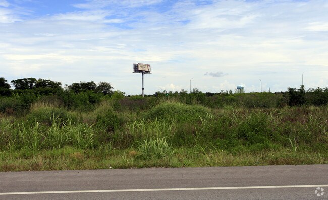
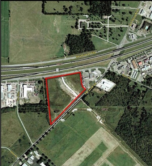
2950 Fm 2218 Rd, Rosenberg, TX 77471

Property Detail
2950 Fm 2218 Rd
Houston-Pasadena-The Woodlands, TX
0340 J D VERMILLION, ACRES 9.5649, RESTRICTED RESERVE B (COMMERCIAL), BLOCK 2, THREE MILE CROSSING
0340-00-000-0215-901
Fort Bend
Commercialnec
Texas
B and X Area of moderate flood hazard, usually the area between the limits of the 100-year and 500-year floods.
9.57 AC
2024
Southwest Outlier
2025
Houston
675501
NEARBY LISTINGS FOR SALE OR LEASE
DEMOGRAPHICS near 2950 Fm 2218 Rd
1 mile
3 mile
5 mile
2025 Total Population
2,778
68,175
118,360
2030 Population
3,189
78,130
135,738
Pop Growth 2025-2030
+ 14.79%
+ 14.60%
+ 14.68%
Average Age
37
37
37
2025 Total Households
936
23,151
39,512
HH Growth 2025-2030
+ 15.17%
+ 14.99%
+ 15.10%
Median Household Inc
$79,086
$75,520
$82,966
Avg Household Size
2.90
2.90
2.90
2025 Avg HH Vehicles
2.00
2.00
2.00
Median Home Value
$242,751
$270,244
$313,658
Median Year Built
2010
2008
2010
Nearby Places
Map Layers
Map Styles
 Street
 Aerial
Layers
 Traffic
 Biking
Places
Listings with unknown addresses are not visible on the map
- Restaurants
- Banks
- Shops
- Fitness
- Groceries
Nearby Properties
Address
Land Use
TOTAL SIZE
Lot Size
Zoning
Address
Land Use
TOTAL SIZE
Lot Size
Zoning
50.46 AC
Address
Land Use
TOTAL SIZE
Lot Size
Zoning
44.35 AC
YOSN
Address
Land Use
TOTAL SIZE
Lot Size
Zoning
449,167 SF
73.44 AC
IY
Address
Land Use
TOTAL SIZE
Lot Size
Zoning
283,393 SF
93.42 AC
Address
Land Use
TOTAL SIZE
Lot Size
Zoning
10.84 AC
Address
Land Use
TOTAL SIZE
Lot Size
Zoning
307,832 SF
14.06 AC
Address
Land Use
TOTAL SIZE
Lot Size
Zoning
15.95 AC
Address
Land Use
TOTAL SIZE
Lot Size
Zoning
Address
Land Use
TOTAL SIZE
Lot Size
Zoning
13.21 AC
Address
Land Use
TOTAL SIZE
Lot Size
Zoning
78,077 SF
16.29 AC
Address
Land Use
TOTAL SIZE
Lot Size
Zoning
17.73 AC
Address
Land Use
TOTAL SIZE
Lot Size
Zoning
224,099 SF
11.85 AC
Address
Land Use
TOTAL SIZE
Lot Size
Zoning
11.40 AC
Address
Land Use
TOTAL SIZE
Lot Size
Zoning
Address
Land Use
TOTAL SIZE
Lot Size
Zoning
98,691 SF
29.37 AC
Address
Land Use
TOTAL SIZE
Lot Size
Zoning
129,092 SF
9.55 AC
Address
Land Use
TOTAL SIZE
Lot Size
Zoning
16.23 AC
Address
Land Use
TOTAL SIZE
Lot Size
Zoning
60.86 AC
Address
Land Use
TOTAL SIZE
Lot Size
Zoning
54,406 SF
13.13 AC
Address
Land Use
TOTAL SIZE
Lot Size
Zoning
3,680 SF
38.68 AC
SMH
Address
Land Use
TOTAL SIZE
Lot Size
Zoning
18.86 AC
Address
Land Use
TOTAL SIZE
Lot Size
Zoning
12.21 AC
Address
Land Use
TOTAL SIZE
Lot Size
Zoning
96,992 SF
14.76 AC
SM
Address
Land Use
TOTAL SIZE
Lot Size
Zoning
2,131 SF
17.68 AC
Address
Land Use
TOTAL SIZE
Lot Size
Zoning
95,890 SF
14.26 AC
Address
Land Use
TOTAL SIZE
Lot Size
Zoning
64.02 AC
YQ
Address
Land Use
TOTAL SIZE
Lot Size
Zoning
90,741 SF
11.82 AC
Address
Land Use
TOTAL SIZE
Lot Size
Zoning
123,941 SF
11.24 AC
Address
Land Use
TOTAL SIZE
Lot Size
Zoning
94,080 SF
6.23 AC
H
Address
Land Use
TOTAL SIZE
Lot Size
Zoning
132,171 SF
8.86 AC
The World's #1 Commercial Real Estate Marketplace
Connect with us
© 2026 CoStar Group
The information above has been obtained from sources believed reliable. While we do not doubt its accuracy we have not verified it and make no guarantee, warranty or representation about it. It is your responsibility to independently confirm its accuracy and completeness. Any projections, opinions, assumptions, or estimates used are for example only and do not represent the current or future performance of the property. The value of this transaction to you depends on tax and other factors which should be evaluated by your tax, financial, and legal advisors. You and your advisors should conduct a careful, independent investigation of the property to determine to your satisfaction the suitability of the property for your needs.