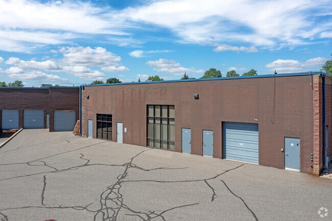
Property Record
2950 Xenium Ln N, Minneapolis, MN 55441


Current Lease Availabilities
NEARBY LISTINGS FOR SALE OR LEASE
Property Detail
2950 Xenium Ln N
Minneapolis-St. Paul-Bloomington, MN-WI
Northwest Business Campus 11Th Addn
22-118-22-42-0012
LOT 001 BLOCK 001 T NORTHWEST BUSINESS CAMPUS 11TH ADDN IRREGULAR
Industrialgeneral
Hennepin
AE
Minnesota
27053C0190F
1
2024
8.66 AC
2024
Northwest
026514
Minneapolis/St Paul
DEMOGRAPHICS near 2950 Xenium Ln N
1 Mile
3 Mile
5 Mile
2024 Total Population
4,862
65,636
175,553
2029 Population
4,782
64,446
172,893
Pop Growth 2024-2029
(1.65%)
(1.81%)
(1.52%)
Average Age
39
42
41
2024 Total Households
2,121
27,382
71,810
HH Growth 2024-2029
(1.70%)
(1.91%)
(1.68%)
Median Household Inc
$106,891
$105,789
$104,387
Avg Household Size
2.30
2.30
2.40
2024 Avg HH Vehicles
2.00
2.00
2.00
Median Home Value
$413,537
$390,098
$379,024
Median Year Built
1983
1983
1981
Nearby Places
Map Layers
Map Styles
 Street
 Aerial
- Restaurants
- Banks
- Shops
- Fitness
- Groceries
PUBLIC TRANSPORTATION
COMMUTER RAIL
Target Field Station (Northstar Corridor - Northstar Commuter Rail)
DRIVE
WALK
Distance
Target Field Station (Northstar Corridor - Northstar Commuter Rail)
18 min
9.8 mi
AIRPORT
Minneapolis-St Paul International/Wold-Chamberlain
DRIVE
WALK
Distance
Minneapolis-St Paul International/Wold-Chamberlain
33 min
23.1 mi
Nearby Properties
Address
Land Use
TOTAL SIZE
Lot Size
Zoning
Address
Land Use
TOTAL SIZE
Lot Size
Zoning
35.53 AC
Address
Land Use
TOTAL SIZE
Lot Size
Zoning
324,564 SF
32.54 AC
PID
Address
Land Use
TOTAL SIZE
Lot Size
Zoning
14.19 AC
Address
Land Use
TOTAL SIZE
Lot Size
Zoning
16.32 AC
Address
Land Use
TOTAL SIZE
Lot Size
Zoning
17.26 AC
Address
Land Use
TOTAL SIZE
Lot Size
Zoning
20,710 SF
7.69 AC
PID
Address
Land Use
TOTAL SIZE
Lot Size
Zoning
20,710 SF
7.69 AC
PID
Address
Land Use
TOTAL SIZE
Lot Size
Zoning
6.47 AC
Address
Land Use
TOTAL SIZE
Lot Size
Zoning
202,718 SF
14.37 AC
PID
Address
Land Use
TOTAL SIZE
Lot Size
Zoning
196,498 SF
13.13 AC
PID
Address
Land Use
TOTAL SIZE
Lot Size
Zoning
11.93 AC
PID
Address
Land Use
TOTAL SIZE
Lot Size
Zoning
Address
Land Use
TOTAL SIZE
Lot Size
Zoning
15.86 AC
Address
Land Use
TOTAL SIZE
Lot Size
Zoning
40.17 AC
Address
Land Use
TOTAL SIZE
Lot Size
Zoning
18.95 AC
Address
Land Use
TOTAL SIZE
Lot Size
Zoning
22.20 AC
Address
Land Use
TOTAL SIZE
Lot Size
Zoning
16.35 AC
Address
Land Use
TOTAL SIZE
Lot Size
Zoning
2.69 AC
Address
Land Use
TOTAL SIZE
Lot Size
Zoning
22.67 AC
Address
Land Use
TOTAL SIZE
Lot Size
Zoning
12.38 AC
Address
Land Use
TOTAL SIZE
Lot Size
Zoning
43,180 SF
10.28 AC
PID
Address
Land Use
TOTAL SIZE
Lot Size
Zoning
43,180 SF
10.94 AC
PID
Address
Land Use
TOTAL SIZE
Lot Size
Zoning
16.11 AC
Address
Land Use
TOTAL SIZE
Lot Size
Zoning
20.48 AC
Address
Land Use
TOTAL SIZE
Lot Size
Zoning
18.65 AC
Address
Land Use
TOTAL SIZE
Lot Size
Zoning
Address
Land Use
TOTAL SIZE
Lot Size
Zoning
11.96 AC
Address
Land Use
TOTAL SIZE
Lot Size
Zoning
12.96 AC
Address
Land Use
TOTAL SIZE
Lot Size
Zoning
Address
Land Use
TOTAL SIZE
Lot Size
Zoning
0.80 AC
The World's #1 Commercial Real Estate Marketplace
Connect with us
© 2026 CoStar Group
The information above has been obtained from sources believed reliable. While we do not doubt its accuracy we have not verified it and make no guarantee, warranty or representation about it. It is your responsibility to independently confirm its accuracy and completeness. Any projections, opinions, assumptions, or estimates used are for example only and do not represent the current or future performance of the property. The value of this transaction to you depends on tax and other factors which should be evaluated by your tax, financial, and legal advisors. You and your advisors should conduct a careful, independent investigation of the property to determine to your satisfaction the suitability of the property for your needs.