Property Record
2950 S John Redditt Dr, Lufkin, TX 75904
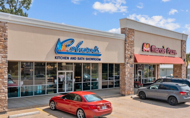

Property Detail
2950 S John Redditt Dr
31051
ABS 0463 MCKINN & WILL,TRACT 7,ACRES 3.191
Stripcommercialcenter
Angelina
MH
Texas
B and X Area of moderate flood hazard, usually the area between the limits of the 100-year and 500-year floods.
3.19 AC
2025
Texas East Area
2025
Other Market Areas
000902
Lufkin, TX
32,029 SF
NEARBY LISTINGS FOR SALE OR LEASE
DEMOGRAPHICS near 2950 S John Redditt Dr
1 mile
3 mile
5 mile
2024 Total Population
3,414
27,599
44,526
2029 Population
3,428
27,688
44,851
Pop Growth 2024-2029
+ 0.41%
+ 0.32%
+ 0.73%
Average Age
38
39
38
2024 Total Households
1,468
10,718
17,008
HH Growth 2024-2029
+ 0.41%
+ 0.32%
+ 0.76%
Median Household Inc
$46,384
$55,349
$53,245
Avg Household Size
2.30
2.50
2.50
2024 Avg HH Vehicles
2.00
2.00
2.00
Median Home Value
$192,547
$176,592
$170,978
Median Year Built
1985
1980
1981
Nearby Places
Map Layers
Map Styles
 Street
 Aerial
Transit
 Traffic
 Biking
Places
Listings with unknown addresses are not visible on the map
- Restaurants
- Banks
- Shops
- Fitness
- Groceries
SALE & LEASE HISTORY
LISTING DATE
SALE/LEASE

Oct 23, 2017
For Lease
Nearby Properties
Address
Land Use
TOTAL SIZE
Lot Size
Zoning
Address
Land Use
TOTAL SIZE
Lot Size
Zoning
379,938 SF
32.47 AC
CSU
Address
Land Use
TOTAL SIZE
Lot Size
Zoning
9,222 SF
10.69 AC
Address
Land Use
TOTAL SIZE
Lot Size
Zoning
34,528 SF
1.86 AC
CBD
Address
Land Use
TOTAL SIZE
Lot Size
Zoning
13,632 SF
28.08 AC
Address
Land Use
TOTAL SIZE
Lot Size
Zoning
217,014 SF
8.58 AC
Address
Land Use
TOTAL SIZE
Lot Size
Zoning
194,526 SF
14.99 AC
LBSU
Address
Land Use
TOTAL SIZE
Lot Size
Zoning
108,460 SF
11.39 AC
Address
Land Use
TOTAL SIZE
Lot Size
Zoning
67,014 SF
23.42 AC
Address
Land Use
TOTAL SIZE
Lot Size
Zoning
60,189 SF
46.10 AC
Address
Land Use
TOTAL SIZE
Lot Size
Zoning
2,319 SF
19.10 AC
Address
Land Use
TOTAL SIZE
Lot Size
Zoning
2,576 SF
14.68 AC
Address
Land Use
TOTAL SIZE
Lot Size
Zoning
20,820 SF
17.42 AC
RL
Address
Land Use
TOTAL SIZE
Lot Size
Zoning
52,832 SF
5.47 AC
RL
Address
Land Use
TOTAL SIZE
Lot Size
Zoning
232,026 SF
27.14 AC
Address
Land Use
TOTAL SIZE
Lot Size
Zoning
31,467 SF
41.44 AC
RL
Address
Land Use
TOTAL SIZE
Lot Size
Zoning
68,340 SF
3.52 AC
Address
Land Use
TOTAL SIZE
Lot Size
Zoning
43,552 SF
2.01 AC
Address
Land Use
TOTAL SIZE
Lot Size
Zoning
1,540 SF
7.82 AC
Address
Land Use
TOTAL SIZE
Lot Size
Zoning
107,432 SF
11.25 AC
A
Address
Land Use
TOTAL SIZE
Lot Size
Zoning
54,239 SF
7.51 AC
Address
Land Use
TOTAL SIZE
Lot Size
Zoning
71,140 SF
9.22 AC
Address
Land Use
TOTAL SIZE
Lot Size
Zoning
70,046 SF
9 AC
LM
Address
Land Use
TOTAL SIZE
Lot Size
Zoning
34,536 SF
5.56 AC
Address
Land Use
TOTAL SIZE
Lot Size
Zoning
34,696 SF
2.76 AC
LBSU
Address
Land Use
TOTAL SIZE
Lot Size
Zoning
57,588 SF
5.07 AC
Address
Land Use
TOTAL SIZE
Lot Size
Zoning
10,521 SF
22.92 AC
RL
Address
Land Use
TOTAL SIZE
Lot Size
Zoning
134,748 SF
16.08 AC
CSU
Address
Land Use
TOTAL SIZE
Lot Size
Zoning
126,715 SF
10.93 AC
LB
The World's #1 Commercial Real Estate Marketplace
Connect with us
© 2026 CoStar Group
The information above has been obtained from sources believed reliable. While we do not doubt its accuracy we have not verified it and make no guarantee, warranty or representation about it. It is your responsibility to independently confirm its accuracy and completeness. Any projections, opinions, assumptions, or estimates used are for example only and do not represent the current or future performance of the property. The value of this transaction to you depends on tax and other factors which should be evaluated by your tax, financial, and legal advisors. You and your advisors should conduct a careful, independent investigation of the property to determine to your satisfaction the suitability of the property for your needs.