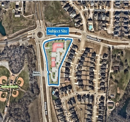
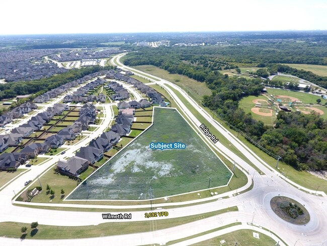
Property Record
2951 N Ridge Rd, Mckinney, TX 75071

NEARBY LISTINGS FOR SALE OR LEASE
Property Detail
2951 N Ridge Rd
Dallas-Fort Worth-Arlington, TX
Malachi Tucker Survey
R-6904-000-0030-1
ABS A0904 MALACHI TUCKER SURVEY, TRACT 3, 3.2400 ACRES
Commercialacreage
Collin
A
Texas
48085C0255J
3
2024
3.24 AC
2025
Allen/McKinney
030605
Dallas/Ft Worth
800 SF
DEMOGRAPHICS near 2951 N Ridge Rd
1 Mile
3 Mile
5 Mile
2024 Total Population
8,660
56,904
178,222
2029 Population
10,704
69,339
216,564
Pop Growth 2024-2029
+ 23.60%
+ 21.85%
+ 21.51%
Average Age
36
37
37
2024 Total Households
2,768
18,326
58,666
HH Growth 2024-2029
+ 23.95%
+ 22.39%
+ 21.88%
Median Household Inc
$122,235
$131,758
$127,035
Avg Household Size
3.10
3.00
3.00
2024 Avg HH Vehicles
2.00
2.00
2.00
Median Home Value
$382,651
$416,717
$417,259
Median Year Built
2011
2007
2006
Nearby Places
Map Layers
Map Styles
 Street
 Aerial
- Restaurants
- Banks
- Shops
- Fitness
- Groceries
PUBLIC TRANSPORTATION
AIRPORT
Dallas Love Field
DRIVE
WALK
Distance
Dallas Love Field
50 min
38.8 mi
Freight Ports
Port of Shreveport
DRIVE
WALK
Distance
Port of Shreveport
246 min
225.0 mi
SALE & LEASE HISTORY
LISTING DATE
SALE/LEASE

May 09, 2023
For Sale
Nearby Properties
Address
Land Use
TOTAL SIZE
Lot Size
Zoning
Address
Land Use
TOTAL SIZE
Lot Size
Zoning
1,826,199 SF
117.79 AC
Address
Land Use
TOTAL SIZE
Lot Size
Zoning
469,170 SF
56.84 AC
Address
Land Use
TOTAL SIZE
Lot Size
Zoning
621,249 SF
80.03 AC
Address
Land Use
TOTAL SIZE
Lot Size
Zoning
691,265 SF
53.52 AC
Address
Land Use
TOTAL SIZE
Lot Size
Zoning
681,949 SF
71.30 AC
Address
Land Use
TOTAL SIZE
Lot Size
Zoning
641,090 SF
60.44 AC
Address
Land Use
TOTAL SIZE
Lot Size
Zoning
398,732 SF
25.88 AC
MF-M
Address
Land Use
TOTAL SIZE
Lot Size
Zoning
274,184 SF
20.34 AC
COMM
Address
Land Use
TOTAL SIZE
Lot Size
Zoning
123,000 SF
0.41 AC
LAC2
Address
Land Use
TOTAL SIZE
Lot Size
Zoning
282,528 SF
5.14 AC
MF-R
Address
Land Use
TOTAL SIZE
Lot Size
Zoning
264,070 SF
15.74 AC
MF-M
Address
Land Use
TOTAL SIZE
Lot Size
Zoning
197,115 SF
10.37 AC
MF-M
Address
Land Use
TOTAL SIZE
Lot Size
Zoning
243,827 SF
13.23 AC
MF
Address
Land Use
TOTAL SIZE
Lot Size
Zoning
201,902 SF
11.22 AC
MF-M
Address
Land Use
TOTAL SIZE
Lot Size
Zoning
216,591 SF
33.51 AC
Address
Land Use
TOTAL SIZE
Lot Size
Zoning
151,317 SF
11.58 AC
Address
Land Use
TOTAL SIZE
Lot Size
Zoning
118,608 SF
5.24 AC
Address
Land Use
TOTAL SIZE
Lot Size
Zoning
105,321 SF
12.29 AC
Address
Land Use
TOTAL SIZE
Lot Size
Zoning
126,334 SF
26.04 AC
Address
Land Use
TOTAL SIZE
Lot Size
Zoning
113,730 SF
Address
Land Use
TOTAL SIZE
Lot Size
Zoning
202,093 SF
23.07 AC
Address
Land Use
TOTAL SIZE
Lot Size
Zoning
56,973 SF
6.78 AC
PD
Address
Land Use
TOTAL SIZE
Lot Size
Zoning
81,464 SF
19.93 AC
Address
Land Use
TOTAL SIZE
Lot Size
Zoning
73,256 SF
4.97 AC
Address
Land Use
TOTAL SIZE
Lot Size
Zoning
117,132 SF
6.78 AC
MF-H
Address
Land Use
TOTAL SIZE
Lot Size
Zoning
34,659 SF
4.71 AC
Address
Land Use
TOTAL SIZE
Lot Size
Zoning
7,820 SF
24.09 AC
Address
Land Use
TOTAL SIZE
Lot Size
Zoning
179,025 SF
2.35 AC
Address
Land Use
TOTAL SIZE
Lot Size
Zoning
63,028 SF
12.04 AC
Address
Land Use
TOTAL SIZE
Lot Size
Zoning
207,340 SF
21.66 AC
The World's #1 Commercial Real Estate Marketplace
Connect with us
© 2026 CoStar Group
The information above has been obtained from sources believed reliable. While we do not doubt its accuracy we have not verified it and make no guarantee, warranty or representation about it. It is your responsibility to independently confirm its accuracy and completeness. Any projections, opinions, assumptions, or estimates used are for example only and do not represent the current or future performance of the property. The value of this transaction to you depends on tax and other factors which should be evaluated by your tax, financial, and legal advisors. You and your advisors should conduct a careful, independent investigation of the property to determine to your satisfaction the suitability of the property for your needs.