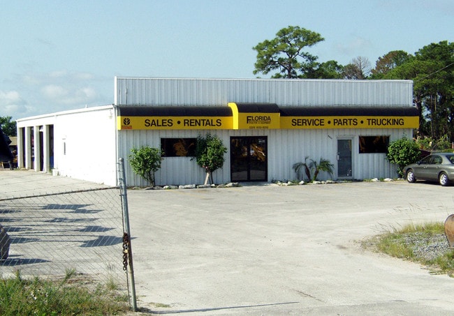
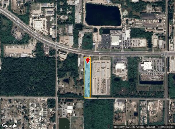
Property Record
2951 W King St, Cocoa, FL 32926
NEARBY LISTINGS FOR SALE OR LEASE
Property Detail
2951 W King St
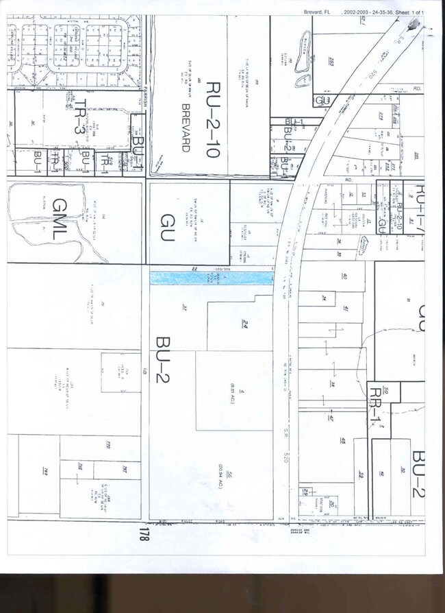
24-35-36-00-00006.0-0000.00
W 150 FT OF E1/2 OF SW1/4 OF NE 1/4 S OF ST RD 520 AS DESC IN ORB 1030 PG 309 & ORB 1384 PG 535 EXC RD R/W PAR 22
Officebuilding
Brevard
X
Florida
12009C0425G
3.40 AC
2024
Brevard County
2025
Orlando
062500
Palm Bay-Melbourne-Titusville, FL
8,840 SF
DEMOGRAPHICS near 2951 W King St
1 Mile
3 Mile
5 Mile
2024 Total Population
3,872
35,378
70,550
2029 Population
4,310
38,939
77,198
Pop Growth 2024-2029
+ 11.31%
+ 10.07%
+ 9.42%
Average Age
40
41
43
2024 Total Households
1,444
14,331
29,268
HH Growth 2024-2029
+ 11.01%
+ 9.83%
+ 9.17%
Median Household Inc
$33,186
$45,930
$55,444
Avg Household Size
2.50
2.40
2.30
2024 Avg HH Vehicles
2.00
2.00
2.00
Median Home Value
$141,642
$191,023
$240,620
Median Year Built
1975
1979
1980
Nearby Places
Map Layers
Map Styles
 Street
 Aerial
- Restaurants
- Banks
- Shops
- Fitness
- Groceries
PUBLIC TRANSPORTATION
AIRPORT
Melbourne Orlando International
DRIVE
WALK
Distance
Melbourne Orlando International
37 min
25.9 mi
Orlando International
DRIVE
WALK
Distance
Orlando International
46 min
38.3 mi
Freight Ports
Port Canaveral
DRIVE
WALK
Distance
Port Canaveral
22 min
13.6 mi
Nearby Properties
Address
Land Use
TOTAL SIZE
Lot Size
Zoning
Address
Land Use
TOTAL SIZE
Lot Size
Zoning
658,069 SF
268.45 AC
RU17
Address
Land Use
TOTAL SIZE
Lot Size
Zoning
825,903 SF
94.80 AC
RU17
Address
Land Use
TOTAL SIZE
Lot Size
Zoning
497,135 SF
34.13 AC
CW
Address
Land Use
TOTAL SIZE
Lot Size
Zoning
307,934 SF
13.66 AC
RU215
Address
Land Use
TOTAL SIZE
Lot Size
Zoning
264,679 SF
59.90 AC
RU17
Address
Land Use
TOTAL SIZE
Lot Size
Zoning
8.30 AC
CW
Address
Land Use
TOTAL SIZE
Lot Size
Zoning
102,141 SF
47.88 AC
BU1
Address
Land Use
TOTAL SIZE
Lot Size
Zoning
101,945 SF
11.15 AC
CG
Address
Land Use
TOTAL SIZE
Lot Size
Zoning
174,500 SF
13.34 AC
RU-2-10
Address
Land Use
TOTAL SIZE
Lot Size
Zoning
141,592 SF
20.22 AC
CG
Address
Land Use
TOTAL SIZE
Lot Size
Zoning
96,878 SF
17.47 AC
CN
Address
Land Use
TOTAL SIZE
Lot Size
Zoning
110,630 SF
31.39 AC
R2
Address
Land Use
TOTAL SIZE
Lot Size
Zoning
117,078 SF
6.13 AC
R2A 8/1
Address
Land Use
TOTAL SIZE
Lot Size
Zoning
75,552 SF
9.95 AC
PUD
Address
Land Use
TOTAL SIZE
Lot Size
Zoning
101,494 SF
5.81 AC
CC
Address
Land Use
TOTAL SIZE
Lot Size
Zoning
96,814 SF
8.89 AC
RU215
Address
Land Use
TOTAL SIZE
Lot Size
Zoning
49,208 SF
18.28 AC
Address
Land Use
TOTAL SIZE
Lot Size
Zoning
101,294 SF
20.14 AC
M2
Address
Land Use
TOTAL SIZE
Lot Size
Zoning
86,391 SF
12.02 AC
GU
Address
Land Use
TOTAL SIZE
Lot Size
Zoning
109,153 SF
20 AC
RU17
Address
Land Use
TOTAL SIZE
Lot Size
Zoning
59,448 SF
6.46 AC
RU2-15
Address
Land Use
TOTAL SIZE
Lot Size
Zoning
163,409 SF
11.95 AC
R3
Address
Land Use
TOTAL SIZE
Lot Size
Zoning
107,340 SF
7.64 AC
CR
Address
Land Use
TOTAL SIZE
Lot Size
Zoning
222,813 SF
20.01 AC
CP
Address
Land Use
TOTAL SIZE
Lot Size
Zoning
97,966 SF
17.08 AC
RU17
Address
Land Use
TOTAL SIZE
Lot Size
Zoning
77,885 SF
11.54 AC
BU2
Address
Land Use
TOTAL SIZE
Lot Size
Zoning
85,320 SF
12 AC
R2
Address
Land Use
TOTAL SIZE
Lot Size
Zoning
79,371 SF
12.44 AC
RU17
Address
Land Use
TOTAL SIZE
Lot Size
Zoning
38,033 SF
10.72 AC
Address
Land Use
TOTAL SIZE
Lot Size
Zoning
92,025 SF
3.08 AC
RU225
The World's #1 Commercial Real Estate Marketplace
Connect with us
© 2025 CoStar Group
The information above has been obtained from sources believed reliable. While we do not doubt its accuracy we have not verified it and make no guarantee, warranty or representation about it. It is your responsibility to independently confirm its accuracy and completeness. Any projections, opinions, assumptions, or estimates used are for example only and do not represent the current or future performance of the property. The value of this transaction to you depends on tax and other factors which should be evaluated by your tax, financial, and legal advisors. You and your advisors should conduct a careful, independent investigation of the property to determine to your satisfaction the suitability of the property for your needs.