Property Record
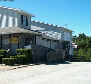
2952 Old Tobacco Rd, Hephzibah, GA 30815
NEARBY LISTINGS FOR SALE OR LEASE
Property Detail
2952 Old Tobacco Rd
1280009010
2960 TOBACCO RD
Religious
Richmond
X
Georgia
13245C0115G
3.44 AC
2025
South Richmond County
2025
Augusta/Richmond County
010707
Augusta-Richmond County, GA-SC
7,142 SF
DEMOGRAPHICS near 2952 Old Tobacco Rd
1 Mile
3 Mile
5 Mile
2024 Total Population
6,436
35,127
78,428
2029 Population
6,467
34,684
77,897
Pop Growth 2024-2029
+ 0.48%
(1.26%)
(0.68%)
Average Age
30
35
37
2024 Total Households
1,574
10,516
26,313
HH Growth 2024-2029
+ 0.64%
(1.42%)
(0.70%)
Median Household Inc
$48,783
$53,479
$54,768
Avg Household Size
2.80
2.80
2.70
2024 Avg HH Vehicles
2.00
2.00
2.00
Median Home Value
$152,927
$142,756
$138,214
Median Year Built
1991
1985
1985
Nearby Places
Map Layers
Map Styles
 Street
 Aerial
- Restaurants
- Banks
- Shops
- Fitness
- Groceries
PUBLIC TRANSPORTATION
AIRPORT
Augusta Regional at Bush Field
DRIVE
WALK
Distance
Augusta Regional at Bush Field
24 min
11.8 mi
Nearby Properties
Address
Land Use
TOTAL SIZE
Lot Size
Zoning
Address
Land Use
TOTAL SIZE
Lot Size
Zoning
1 SF
1.02 AC
007
Address
Land Use
TOTAL SIZE
Lot Size
Zoning
252,567 SF
18.59 AC
R-3B
Address
Land Use
TOTAL SIZE
Lot Size
Zoning
4,196 SF
30.70 AC
R-3A
Address
Land Use
TOTAL SIZE
Lot Size
Zoning
94,579 SF
60.10 AC
R-1
Address
Land Use
TOTAL SIZE
Lot Size
Zoning
5,636 SF
32.26 AC
B-2
Address
Land Use
TOTAL SIZE
Lot Size
Zoning
41,664 SF
12.52 AC
R-3A
Address
Land Use
TOTAL SIZE
Lot Size
Zoning
22,080 SF
19.49 AC
R-3B
Address
Land Use
TOTAL SIZE
Lot Size
Zoning
80,453 SF
23.92 AC
R-1B
Address
Land Use
TOTAL SIZE
Lot Size
Zoning
2,040 SF
18.66 AC
R-1C SPEX
Address
Land Use
TOTAL SIZE
Lot Size
Zoning
80,038 SF
19.49 AC
R-1A
Address
Land Use
TOTAL SIZE
Lot Size
Zoning
1,936 SF
13.39 AC
B-1
Address
Land Use
TOTAL SIZE
Lot Size
Zoning
2,895 SF
1,199.90 AC
A
Address
Land Use
TOTAL SIZE
Lot Size
Zoning
680 SF
11.03 AC
R-3C
Address
Land Use
TOTAL SIZE
Lot Size
Zoning
19,771 SF
23 AC
A
Address
Land Use
TOTAL SIZE
Lot Size
Zoning
1,800 SF
4.30 AC
B-2
Address
Land Use
TOTAL SIZE
Lot Size
Zoning
48,175 SF
6.55 AC
B-2
Address
Land Use
TOTAL SIZE
Lot Size
Zoning
23,152 SF
9.49 AC
A_B-2
Address
Land Use
TOTAL SIZE
Lot Size
Zoning
11,013 SF
43.41 AC
R-3B SPEX
Address
Land Use
TOTAL SIZE
Lot Size
Zoning
48,000 SF
4.09 AC
B-2
Address
Land Use
TOTAL SIZE
Lot Size
Zoning
8,960 SF
2.06 AC
B-2
Address
Land Use
TOTAL SIZE
Lot Size
Zoning
48,152 SF
5.46 AC
B-2
Address
Land Use
TOTAL SIZE
Lot Size
Zoning
17,472 SF
9.80 AC
R-3B
Address
Land Use
TOTAL SIZE
Lot Size
Zoning
10,000 SF
6.36 AC
LI
Address
Land Use
TOTAL SIZE
Lot Size
Zoning
19,083 SF
6.17 AC
POPD
Address
Land Use
TOTAL SIZE
Lot Size
Zoning
26,302 SF
7.88 AC
A,R
Address
Land Use
TOTAL SIZE
Lot Size
Zoning
53,083 SF
6.68 AC
B-2
Address
Land Use
TOTAL SIZE
Lot Size
Zoning
3,361 SF
1.14 AC
B-2
Address
Land Use
TOTAL SIZE
Lot Size
Zoning
750 SF
2.62 AC
B-2
Address
Land Use
TOTAL SIZE
Lot Size
Zoning
15,145 SF
6.64 AC
B-1
Address
Land Use
TOTAL SIZE
Lot Size
Zoning
11,520 SF
8.31 AC
007
The World's #1 Commercial Real Estate Marketplace
Connect with us
© 2026 CoStar Group
The information above has been obtained from sources believed reliable. While we do not doubt its accuracy we have not verified it and make no guarantee, warranty or representation about it. It is your responsibility to independently confirm its accuracy and completeness. Any projections, opinions, assumptions, or estimates used are for example only and do not represent the current or future performance of the property. The value of this transaction to you depends on tax and other factors which should be evaluated by your tax, financial, and legal advisors. You and your advisors should conduct a careful, independent investigation of the property to determine to your satisfaction the suitability of the property for your needs.