Property Record
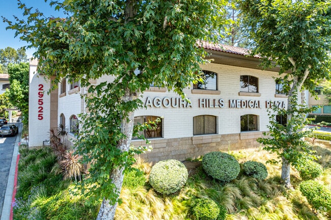
29525 Canwood St, Agoura Hills, CA 91301


Current Lease Availabilities
NEARBY LISTINGS FOR SALE OR LEASE
Property Detail
29525 Canwood St
Los Angeles-Long Beach-Glendale, CA
Rancho Las Virgenes
2053-001-007
LICENSED SURVEYORS MAP AS PER BK 15 P 8-9 OF L S EX OF ST LOT 55
Medicalbuilding
Los Angeles
X
California
06111C0995E
55
2024
3.94 AC
2025
Calabasas/Westlake Vill
800324
Los Angeles
186,905 SF
DEMOGRAPHICS near 29525 Canwood St
1 Mile
3 Mile
5 Mile
2024 Total Population
8,394
40,062
73,822
2029 Population
8,106
38,989
72,061
Pop Growth 2024-2029
(3.43%)
(2.68%)
(2.39%)
Average Age
43
44
44
2024 Total Households
3,023
15,052
28,783
HH Growth 2024-2029
(3.67%)
(2.84%)
(2.54%)
Median Household Inc
$136,987
$147,483
$137,614
Avg Household Size
2.70
2.60
2.50
2024 Avg HH Vehicles
2.00
2.00
2.00
Median Home Value
$906,398
$939,415
$989,128
Median Year Built
1982
1982
1981
Nearby Places
Map Layers
Map Styles
 Street
 Aerial
- Restaurants
- Banks
- Shops
- Fitness
- Groceries
PUBLIC TRANSPORTATION
AIRPORT
Bob Hope
DRIVE
WALK
Distance
Bob Hope
38 min
28.1 mi
Los Angeles International
DRIVE
WALK
Distance
Los Angeles International
48 min
36.2 mi
Freight Ports
The Port of Hueneme
DRIVE
WALK
Distance
The Port of Hueneme
41 min
28.9 mi
Nearby Properties
Address
Land Use
TOTAL SIZE
Lot Size
Zoning
Address
Land Use
TOTAL SIZE
Lot Size
Zoning
676,545 SF
19.76 AC
WVM1*
Address
Land Use
TOTAL SIZE
Lot Size
Zoning
142,150 SF
15.35 AC
AH SP*
Address
Land Use
TOTAL SIZE
Lot Size
Zoning
736,464 SF
19.64 AC
WVM1*
Address
Land Use
TOTAL SIZE
Lot Size
Zoning
163,773 SF
5.80 AC
Address
Land Use
TOTAL SIZE
Lot Size
Zoning
142,738 SF
5.56 AC
AH BP-M-FC
Address
Land Use
TOTAL SIZE
Lot Size
Zoning
168,729 SF
10.21 AC
WVM1*
Address
Land Use
TOTAL SIZE
Lot Size
Zoning
142,578 SF
6.13 AC
Address
Land Use
TOTAL SIZE
Lot Size
Zoning
169,597 SF
7.19 AC
AH SP*
Address
Land Use
TOTAL SIZE
Lot Size
Zoning
116,906 SF
6.35 AC
LCA21*
Address
Land Use
TOTAL SIZE
Lot Size
Zoning
201,223 SF
6.94 AC
LCA21*
Address
Land Use
TOTAL SIZE
Lot Size
Zoning
365,098 SF
18.18 AC
WVM1*
Address
Land Use
TOTAL SIZE
Lot Size
Zoning
42,203 SF
16.37 AC
CHEVRON TE
Address
Land Use
TOTAL SIZE
Lot Size
Zoning
138,762 SF
8.69 AC
LCA21*
Address
Land Use
TOTAL SIZE
Lot Size
Zoning
98,127 SF
2.56 AC
AHRA20000*
Address
Land Use
TOTAL SIZE
Lot Size
Zoning
230,960 SF
6.99 AC
WVM1*
Address
Land Use
TOTAL SIZE
Lot Size
Zoning
115,790 SF
5.41 AC
WVM1*
Address
Land Use
TOTAL SIZE
Lot Size
Zoning
86,558 SF
8.83 AC
AHC3*
Address
Land Use
TOTAL SIZE
Lot Size
Zoning
117,968 SF
6.19 AC
AH BP-M-FC
Address
Land Use
TOTAL SIZE
Lot Size
Zoning
71,159 SF
5.74 AC
AH BP-OR-F
Address
Land Use
TOTAL SIZE
Lot Size
Zoning
Address
Land Use
TOTAL SIZE
Lot Size
Zoning
65,546 SF
4.08 AC
LCA21*
Address
Land Use
TOTAL SIZE
Lot Size
Zoning
183,251 SF
11.60 AC
RPD-19-
Address
Land Use
TOTAL SIZE
Lot Size
Zoning
191,936 SF
11.59 AC
RPD-19-
Address
Land Use
TOTAL SIZE
Lot Size
Zoning
94,555 SF
3.28 AC
CRS
Address
Land Use
TOTAL SIZE
Lot Size
Zoning
137,738 SF
10.29 AC
LCA21*
Address
Land Use
TOTAL SIZE
Lot Size
Zoning
69,148 SF
3.08 AC
LCA21*
Address
Land Use
TOTAL SIZE
Lot Size
Zoning
157,896 SF
5.74 AC
AH
Address
Land Use
TOTAL SIZE
Lot Size
Zoning
58,092 SF
3.95 AC
AHCRS-FC-O
Address
Land Use
TOTAL SIZE
Lot Size
Zoning
113,871 SF
2.24 AC
LCA21*
Address
Land Use
TOTAL SIZE
Lot Size
Zoning
57,000 SF
5.58 AC
The World's #1 Commercial Real Estate Marketplace
Connect with us
© 2026 CoStar Group
The information above has been obtained from sources believed reliable. While we do not doubt its accuracy we have not verified it and make no guarantee, warranty or representation about it. It is your responsibility to independently confirm its accuracy and completeness. Any projections, opinions, assumptions, or estimates used are for example only and do not represent the current or future performance of the property. The value of this transaction to you depends on tax and other factors which should be evaluated by your tax, financial, and legal advisors. You and your advisors should conduct a careful, independent investigation of the property to determine to your satisfaction the suitability of the property for your needs.