Property Record
2953 Central Dr, Casper, WY 82604


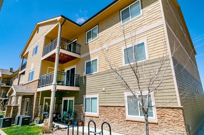
Property Detail
2953 Central Dr
Casper, WY
MESA #5 (RPLT L 40) LOT 43
33-79-19-1-0-202000
NATRONA
Apartmenthouse5plusunits
Wyoming
B and X Area of moderate flood hazard, usually the area between the limits of the 100-year and 500-year floods.
43
2024
2.91 AC
2025
I-25 Corridor/Casper
000901
Other Market Areas
29,358 SF
NEARBY LISTINGS FOR SALE OR LEASE
-
-
View all Casper listings for sale on LoopNet.com
DEMOGRAPHICS near 2953 Central Dr
1 mile
3 mile
5 mile
2025 Total Population
8,078
36,262
63,163
2030 Population
8,192
36,555
63,763
Pop Growth 2025-2030
+ 1.41%
+ 0.81%
+ 0.95%
Average Age
41
41
40
2025 Total Households
3,274
15,096
26,303
HH Growth 2025-2030
+ 1.53%
+ 0.87%
+ 1.02%
Median Household Inc
$78,154
$68,871
$69,203
Avg Household Size
2.40
2.30
2.30
2025 Avg HH Vehicles
2.00
2.00
2.00
Median Home Value
$268,102
$257,788
$261,321
Median Year Built
1967
1969
1973
Nearby Places
Map Layers
Map Styles
 Street
 Aerial
Transit
 Traffic
 Biking
Places
Listings with unknown addresses are not visible on the map
- Restaurants
- Banks
- Shops
- Fitness
- Groceries
PUBLIC TRANSPORTATION
AIRPORT
Casper/Natrona County International
Drive
Walk
Distance
Casper/Natrona County International
29 min
14.9 mi
Freight Ports
Tulsa Port Of Catoosa
Drive
Walk
Distance
Tulsa Port Of Catoosa
999 min
981.8 mi
Nearby Properties
Address
Land Use
TOTAL SIZE
Lot Size
Zoning
Address
Land Use
TOTAL SIZE
Lot Size
Zoning
95,290 SF
0.57 AC
Address
Land Use
TOTAL SIZE
Lot Size
Zoning
81,240 SF
5.86 AC
Address
Land Use
TOTAL SIZE
Lot Size
Zoning
225,342 SF
29.07 AC
Address
Land Use
TOTAL SIZE
Lot Size
Zoning
89,887 SF
5.46 AC
Address
Land Use
TOTAL SIZE
Lot Size
Zoning
88,739 SF
13.39 AC
Address
Land Use
TOTAL SIZE
Lot Size
Zoning
24,240 SF
16.47 AC
Address
Land Use
TOTAL SIZE
Lot Size
Zoning
82,800 SF
5.94 AC
Address
Land Use
TOTAL SIZE
Lot Size
Zoning
43,644 SF
3.35 AC
Address
Land Use
TOTAL SIZE
Lot Size
Zoning
45,297 SF
1.29 AC
Address
Land Use
TOTAL SIZE
Lot Size
Zoning
51,699 SF
10.69 AC
Address
Land Use
TOTAL SIZE
Lot Size
Zoning
46,926 SF
9.56 AC
Address
Land Use
TOTAL SIZE
Lot Size
Zoning
18,340 SF
5.42 AC
Address
Land Use
TOTAL SIZE
Lot Size
Zoning
95,322 SF
2.01 AC
Address
Land Use
TOTAL SIZE
Lot Size
Zoning
38,983 SF
5.09 AC
Address
Land Use
TOTAL SIZE
Lot Size
Zoning
14,205 SF
3.01 AC
Address
Land Use
TOTAL SIZE
Lot Size
Zoning
29,143 SF
3.62 AC
Address
Land Use
TOTAL SIZE
Lot Size
Zoning
28,028 SF
12.99 AC
Address
Land Use
TOTAL SIZE
Lot Size
Zoning
19,695 SF
2.40 AC
Address
Land Use
TOTAL SIZE
Lot Size
Zoning
17,181 SF
0.38 AC
Address
Land Use
TOTAL SIZE
Lot Size
Zoning
39,061 SF
3.61 AC
Address
Land Use
TOTAL SIZE
Lot Size
Zoning
44,582 SF
3.63 AC
Address
Land Use
TOTAL SIZE
Lot Size
Zoning
25,727 SF
1.45 AC
Address
Land Use
TOTAL SIZE
Lot Size
Zoning
63,811 SF
12.23 AC
Address
Land Use
TOTAL SIZE
Lot Size
Zoning
46,734 SF
2.92 AC
Address
Land Use
TOTAL SIZE
Lot Size
Zoning
20,883 SF
0.77 AC
Address
Land Use
TOTAL SIZE
Lot Size
Zoning
8,288 SF
3.50 AC
Address
Land Use
TOTAL SIZE
Lot Size
Zoning
19,951 SF
3 AC
Address
Land Use
TOTAL SIZE
Lot Size
Zoning
8,640 SF
4.11 AC
Address
Land Use
TOTAL SIZE
Lot Size
Zoning
16,306 SF
9.38 AC
Address
Land Use
TOTAL SIZE
Lot Size
Zoning
29,142 SF
6.36 AC
The World's #1 Commercial Real Estate Marketplace
Connect with us
© 2026 CoStar Group
The information above has been obtained from sources believed reliable. While we do not doubt its accuracy we have not verified it and make no guarantee, warranty or representation about it. It is your responsibility to independently confirm its accuracy and completeness. Any projections, opinions, assumptions, or estimates used are for example only and do not represent the current or future performance of the property. The value of this transaction to you depends on tax and other factors which should be evaluated by your tax, financial, and legal advisors. You and your advisors should conduct a careful, independent investigation of the property to determine to your satisfaction the suitability of the property for your needs.