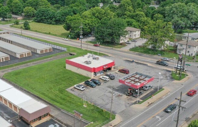
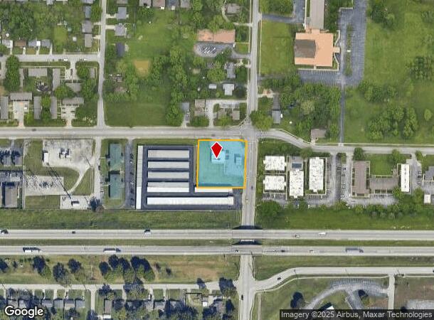
Property Record
2953 N National Ave, Springfield, MO 65803
NEARBY LISTINGS FOR SALE OR LEASE
Property Detail
2953 N National Ave
Springfield, MO
Masseys
13-01-118-001
MASSEYS ADD E 208.71 FT N 208.71 FT LOTS 1 2 3 & 4 BLK 1
Storebuilding
Greene
X
Missouri
29077C0219E
1-4
2025
1 AC
2025
Northeast
004401
Springfield
2,500 SF
DEMOGRAPHICS near 2953 N National Ave
1 Mile
3 Mile
5 Mile
2024 Total Population
8,328
43,890
108,721
2029 Population
8,628
45,687
113,175
Pop Growth 2024-2029
+ 3.60%
+ 4.09%
+ 4.10%
Average Age
40
38
37
2024 Total Households
3,656
17,888
46,896
HH Growth 2024-2029
+ 3.75%
+ 4.35%
+ 4.34%
Median Household Inc
$39,975
$42,246
$41,402
Avg Household Size
2.10
2.20
2.10
2024 Avg HH Vehicles
1.00
2.00
2.00
Median Home Value
$134,170
$123,558
$138,828
Median Year Built
1976
1971
1972
Nearby Places
Map Layers
Map Styles
 Street
 Aerial
- Restaurants
- Banks
- Shops
- Fitness
- Groceries
PUBLIC TRANSPORTATION
AIRPORT
Springfield-Branson Ntl
DRIVE
WALK
Distance
Springfield-Branson Ntl
21 min
10.6 mi
SALE & LEASE HISTORY
LISTING DATE
SALE/LEASE

Jul 16, 2021
For Sale
Nearby Properties
Address
Land Use
TOTAL SIZE
Lot Size
Zoning
Address
Land Use
TOTAL SIZE
Lot Size
Zoning
11.54 AC
Address
Land Use
TOTAL SIZE
Lot Size
Zoning
35.56 AC
INC
Address
Land Use
TOTAL SIZE
Lot Size
Zoning
297,760 SF
4.22 AC
INC
Address
Land Use
TOTAL SIZE
Lot Size
Zoning
22.01 AC
INC.
Address
Land Use
TOTAL SIZE
Lot Size
Zoning
1,728,457 SF
123.60 AC
INC
Address
Land Use
TOTAL SIZE
Lot Size
Zoning
340,000 SF
37.93 AC
INC
Address
Land Use
TOTAL SIZE
Lot Size
Zoning
359,020 SF
14 AC
INC
Address
Land Use
TOTAL SIZE
Lot Size
Zoning
355,759 SF
2.23 AC
INC
Address
Land Use
TOTAL SIZE
Lot Size
Zoning
349,216 SF
29.46 AC
INC
Address
Land Use
TOTAL SIZE
Lot Size
Zoning
5.84 AC
INC
Address
Land Use
TOTAL SIZE
Lot Size
Zoning
24.54 AC
INC.
Address
Land Use
TOTAL SIZE
Lot Size
Zoning
13.88 AC
INC
Address
Land Use
TOTAL SIZE
Lot Size
Zoning
1,825 SF
4.31 AC
INC
Address
Land Use
TOTAL SIZE
Lot Size
Zoning
5.47 AC
INC
Address
Land Use
TOTAL SIZE
Lot Size
Zoning
143,774 SF
5.85 AC
INC
Address
Land Use
TOTAL SIZE
Lot Size
Zoning
290,844 SF
20.78 AC
INC
Address
Land Use
TOTAL SIZE
Lot Size
Zoning
127,740 SF
27.70 AC
INC
Address
Land Use
TOTAL SIZE
Lot Size
Zoning
92,702 SF
42.54 AC
INC
Address
Land Use
TOTAL SIZE
Lot Size
Zoning
20.11 AC
INC
Address
Land Use
TOTAL SIZE
Lot Size
Zoning
186,125 SF
21.09 AC
INC
Address
Land Use
TOTAL SIZE
Lot Size
Zoning
2.75 AC
INC
Address
Land Use
TOTAL SIZE
Lot Size
Zoning
79.50 AC
INC
Address
Land Use
TOTAL SIZE
Lot Size
Zoning
4.62 AC
INC
Address
Land Use
TOTAL SIZE
Lot Size
Zoning
32.40 AC
INC
Address
Land Use
TOTAL SIZE
Lot Size
Zoning
1.69 AC
INC
Address
Land Use
TOTAL SIZE
Lot Size
Zoning
136,629 SF
26.79 AC
INC
Address
Land Use
TOTAL SIZE
Lot Size
Zoning
10.76 AC
INC
Address
Land Use
TOTAL SIZE
Lot Size
Zoning
16.08 AC
Address
Land Use
TOTAL SIZE
Lot Size
Zoning
75.07 AC
INC
Address
Land Use
TOTAL SIZE
Lot Size
Zoning
154,635 SF
9.16 AC
INC
The World's #1 Commercial Real Estate Marketplace
Connect with us
© 2025 CoStar Group
The information above has been obtained from sources believed reliable. While we do not doubt its accuracy we have not verified it and make no guarantee, warranty or representation about it. It is your responsibility to independently confirm its accuracy and completeness. Any projections, opinions, assumptions, or estimates used are for example only and do not represent the current or future performance of the property. The value of this transaction to you depends on tax and other factors which should be evaluated by your tax, financial, and legal advisors. You and your advisors should conduct a careful, independent investigation of the property to determine to your satisfaction the suitability of the property for your needs.