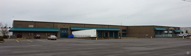
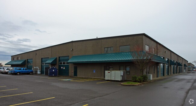
Property Record
29538 Airport Rd, Eugene, OR 97402

Property Detail
29538 Airport Rd
Eugene-Springfield, OR
SUBDIVISION PLAT K & L INDUSTRIAL PARK LOT 7 TL 02100
1688801
Lane
Industrialgeneral
Oregon
I-2
7
B and X Area of moderate flood hazard, usually the area between the limits of the 100-year and 500-year floods.
3.66 AC
2025
Lane County
2025
Portland
002501
NEARBY LISTINGS FOR SALE OR LEASE
DEMOGRAPHICS near 29538 Airport Rd
1 mile
3 mile
5 mile
2025 Total Population
265
44,507
82,625
2030 Population
262
43,778
81,633
Pop Growth 2025-2030
(1.13%)
(1.64%)
(1.20%)
Average Age
44
42
42
2025 Total Households
101
17,120
32,145
HH Growth 2025-2030
(0.99%)
(1.70%)
(1.32%)
Median Household Inc
$76,190
$77,697
$74,692
Avg Household Size
2.50
2.50
2.40
2025 Avg HH Vehicles
2.00
2.00
2.00
Median Home Value
$431,250
$400,885
$404,739
Median Year Built
1994
1979
1980
Nearby Places
Map Layers
Map Styles
 Street
 Aerial
Layers
 Traffic
 Biking
Places
Listings with unknown addresses are not visible on the map
- Restaurants
- Banks
- Shops
- Fitness
- Groceries
PUBLIC TRANSPORTATION
COMMUTER RAIL
Drive
Walk
Distance
14 min
7.1 mi
AIRPORT
Mahlon Sweet Field
Drive
Walk
Distance
Mahlon Sweet Field
7 min
2.4 mi
Nearby Properties
Address
Land Use
TOTAL SIZE
Lot Size
Zoning
Address
Land Use
TOTAL SIZE
Lot Size
Zoning
Address
Land Use
TOTAL SIZE
Lot Size
Zoning
44.56 AC
PL
Address
Land Use
TOTAL SIZE
Lot Size
Zoning
480 SF
35.67 AC
AG
Address
Land Use
TOTAL SIZE
Lot Size
Zoning
664.30 AC
AO
Address
Land Use
TOTAL SIZE
Lot Size
Zoning
27.33 AC
M1
Address
Land Use
TOTAL SIZE
Lot Size
Zoning
121.21 AC
E40
Address
Land Use
TOTAL SIZE
Lot Size
Zoning
Address
Land Use
TOTAL SIZE
Lot Size
Zoning
Address
Land Use
TOTAL SIZE
Lot Size
Zoning
27.47 AC
R-1
Address
Land Use
TOTAL SIZE
Lot Size
Zoning
44.67 AC
I-2
Address
Land Use
TOTAL SIZE
Lot Size
Zoning
29.96 AC
AG
Address
Land Use
TOTAL SIZE
Lot Size
Zoning
14.20 AC
R-1
Address
Land Use
TOTAL SIZE
Lot Size
Zoning
33.70 AC
R-1
Address
Land Use
TOTAL SIZE
Lot Size
Zoning
37.58 AC
PL
Address
Land Use
TOTAL SIZE
Lot Size
Zoning
Address
Land Use
TOTAL SIZE
Lot Size
Zoning
23.08 AC
PL
Address
Land Use
TOTAL SIZE
Lot Size
Zoning
Address
Land Use
TOTAL SIZE
Lot Size
Zoning
10.50 AC
C-2
Address
Land Use
TOTAL SIZE
Lot Size
Zoning
Address
Land Use
TOTAL SIZE
Lot Size
Zoning
2.82 AC
C-2
Address
Land Use
TOTAL SIZE
Lot Size
Zoning
8.13 AC
R-1
Address
Land Use
TOTAL SIZE
Lot Size
Zoning
31.30 AC
I-3
Address
Land Use
TOTAL SIZE
Lot Size
Zoning
4.62 AC
AG
Address
Land Use
TOTAL SIZE
Lot Size
Zoning
Address
Land Use
TOTAL SIZE
Lot Size
Zoning
Address
Land Use
TOTAL SIZE
Lot Size
Zoning
8.61 AC
C-2
Address
Land Use
TOTAL SIZE
Lot Size
Zoning
5.38 AC
I-2
Address
Land Use
TOTAL SIZE
Lot Size
Zoning
8.03 AC
C-2
Address
Land Use
TOTAL SIZE
Lot Size
Zoning
Address
Land Use
TOTAL SIZE
Lot Size
Zoning
The World's #1 Commercial Real Estate Marketplace
Connect with us
© 2026 CoStar Group
The information above has been obtained from sources believed reliable. While we do not doubt its accuracy we have not verified it and make no guarantee, warranty or representation about it. It is your responsibility to independently confirm its accuracy and completeness. Any projections, opinions, assumptions, or estimates used are for example only and do not represent the current or future performance of the property. The value of this transaction to you depends on tax and other factors which should be evaluated by your tax, financial, and legal advisors. You and your advisors should conduct a careful, independent investigation of the property to determine to your satisfaction the suitability of the property for your needs.