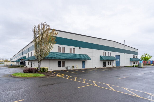
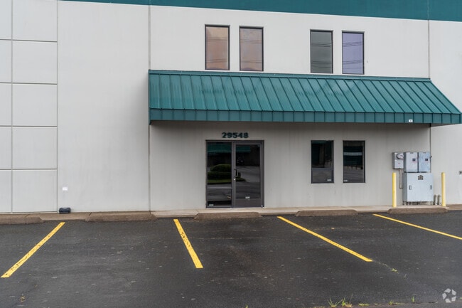
Property Record
29548 Airport Rd, Eugene, OR 97402

Property Detail
29548 Airport Rd
Eugene-Springfield, OR
SUBDIVISION PLAT K & L INDUSTRIAL PARK LOT 4 TL 01800
1688777
Lane
Industrialgeneral
Oregon
I-2
4
B and X Area of moderate flood hazard, usually the area between the limits of the 100-year and 500-year floods.
6.74 AC
2025
Lane County
2025
Portland
002501
NEARBY LISTINGS FOR SALE OR LEASE
DEMOGRAPHICS near 29548 Airport Rd
1 mile
3 mile
5 mile
2025 Total Population
319
46,853
85,382
2030 Population
315
46,100
84,396
Pop Growth 2025-2030
(1.25%)
(1.61%)
(1.15%)
Average Age
44
42
42
2025 Total Households
122
18,064
33,343
HH Growth 2025-2030
(1.64%)
(1.67%)
(1.26%)
Median Household Inc
$77,604
$76,749
$74,481
Avg Household Size
2.50
2.50
2.40
2025 Avg HH Vehicles
2.00
2.00
2.00
Median Home Value
$433,750
$398,705
$406,041
Median Year Built
1994
1979
1980
Nearby Places
Map Layers
Map Styles
 Street
 Aerial
Layers
 Traffic
 Biking
Places
Listings with unknown addresses are not visible on the map
- Restaurants
- Banks
- Shops
- Fitness
- Groceries
PUBLIC TRANSPORTATION
COMMUTER RAIL
Eugene (Amtrak Cascades - Amtrak, Coast Starlight - Amtrak)
Drive
Walk
Distance
Eugene (Amtrak Cascades - Amtrak, Coast Starlight - Amtrak)
12 min
6.9 mi
AIRPORT
Mahlon Sweet Field
Drive
Walk
Distance
Mahlon Sweet Field
7 min
2.4 mi
Freight Ports
Port of Coos Bay, OR
Drive
Walk
Distance
Port of Coos Bay, OR
151 min
108.5 mi
SALE & LEASE HISTORY
LISTING DATE
SALE/LEASE

Sep 13, 2023
For Lease
May 08, 2024
For Lease
Nearby Properties
Address
Land Use
TOTAL SIZE
Lot Size
Zoning
Address
Land Use
TOTAL SIZE
Lot Size
Zoning
Address
Land Use
TOTAL SIZE
Lot Size
Zoning
44.56 AC
PL
Address
Land Use
TOTAL SIZE
Lot Size
Zoning
480 SF
35.67 AC
AG
Address
Land Use
TOTAL SIZE
Lot Size
Zoning
664.30 AC
AO
Address
Land Use
TOTAL SIZE
Lot Size
Zoning
27.33 AC
M1
Address
Land Use
TOTAL SIZE
Lot Size
Zoning
121.21 AC
E40
Address
Land Use
TOTAL SIZE
Lot Size
Zoning
Address
Land Use
TOTAL SIZE
Lot Size
Zoning
Address
Land Use
TOTAL SIZE
Lot Size
Zoning
27.47 AC
R-1
Address
Land Use
TOTAL SIZE
Lot Size
Zoning
44.67 AC
I-2
Address
Land Use
TOTAL SIZE
Lot Size
Zoning
29.96 AC
AG
Address
Land Use
TOTAL SIZE
Lot Size
Zoning
14.20 AC
R-1
Address
Land Use
TOTAL SIZE
Lot Size
Zoning
33.70 AC
R-1
Address
Land Use
TOTAL SIZE
Lot Size
Zoning
37.58 AC
PL
Address
Land Use
TOTAL SIZE
Lot Size
Zoning
Address
Land Use
TOTAL SIZE
Lot Size
Zoning
23.08 AC
PL
Address
Land Use
TOTAL SIZE
Lot Size
Zoning
Address
Land Use
TOTAL SIZE
Lot Size
Zoning
10.50 AC
C-2
Address
Land Use
TOTAL SIZE
Lot Size
Zoning
5.93 AC
C-2
Address
Land Use
TOTAL SIZE
Lot Size
Zoning
Address
Land Use
TOTAL SIZE
Lot Size
Zoning
2.82 AC
C-2
Address
Land Use
TOTAL SIZE
Lot Size
Zoning
8.13 AC
R-1
Address
Land Use
TOTAL SIZE
Lot Size
Zoning
31.30 AC
I-3
Address
Land Use
TOTAL SIZE
Lot Size
Zoning
4.62 AC
AG
Address
Land Use
TOTAL SIZE
Lot Size
Zoning
Address
Land Use
TOTAL SIZE
Lot Size
Zoning
Address
Land Use
TOTAL SIZE
Lot Size
Zoning
8.61 AC
C-2
Address
Land Use
TOTAL SIZE
Lot Size
Zoning
5.38 AC
I-2
Address
Land Use
TOTAL SIZE
Lot Size
Zoning
8.03 AC
C-2
Address
Land Use
TOTAL SIZE
Lot Size
Zoning
The World's #1 Commercial Real Estate Marketplace
Connect with us
© 2026 CoStar Group
The information above has been obtained from sources believed reliable. While we do not doubt its accuracy we have not verified it and make no guarantee, warranty or representation about it. It is your responsibility to independently confirm its accuracy and completeness. Any projections, opinions, assumptions, or estimates used are for example only and do not represent the current or future performance of the property. The value of this transaction to you depends on tax and other factors which should be evaluated by your tax, financial, and legal advisors. You and your advisors should conduct a careful, independent investigation of the property to determine to your satisfaction the suitability of the property for your needs.