Property Record
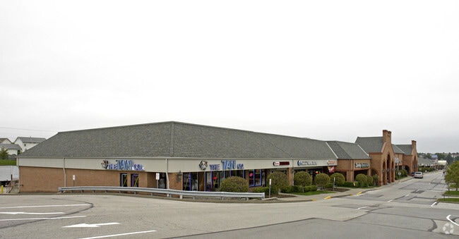
2955 Highway K, O Fallon, MO 63368

Property Detail
2955 Highway K
St. Louis, MO-IL
DEER CREEK CROSSING LOT 8
2-0129-8718-00-0008.1000000
ST. CHARLES
Commercialnec
Missouri
B and X Area of moderate flood hazard, usually the area between the limits of the 100-year and 500-year floods.
8
2024
7.39 AC
2025
St Charles County
311732
St. Louis
74,037 SF
NEARBY LISTINGS FOR SALE OR LEASE
DEMOGRAPHICS near 2955 Highway K
1 mile
3 mile
5 mile
2025 Total Population
11,020
84,428
166,323
2030 Population
11,268
87,314
172,308
Pop Growth 2025-2030
+ 2.25%
+ 3.42%
+ 3.60%
Average Age
39
40
41
2025 Total Households
3,742
30,191
62,102
HH Growth 2025-2030
+ 2.43%
+ 3.64%
+ 3.77%
Median Household Inc
$123,323
$115,965
$104,759
Avg Household Size
2.90
2.70
2.60
2025 Avg HH Vehicles
2.00
2.00
2.00
Median Home Value
$344,595
$350,182
$332,705
Median Year Built
1996
1997
1996
Nearby Places
Map Layers
Map Styles
 Street
 Aerial
Layers
 Traffic
 Biking
Places
Listings with unknown addresses are not visible on the map
- Restaurants
- Banks
- Shops
- Fitness
- Groceries
PUBLIC TRANSPORTATION
AIRPORT
St Louis Lambert International
Drive
Walk
Distance
St Louis Lambert International
33 min
23.2 mi
Freight Ports
Tulsa Port of Inola
Drive
Walk
Distance
Tulsa Port of Inola
423 min
376.1 mi
SALE & LEASE HISTORY
LISTING DATE
SALE/LEASE

Sep 24, 2016
For Lease
Aug 27, 2022
For Lease
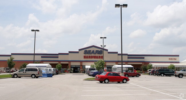
Nearby Properties
Address
Land Use
TOTAL SIZE
Lot Size
Zoning
Address
Land Use
TOTAL SIZE
Lot Size
Zoning
163,438 SF
5.76 AC
Address
Land Use
TOTAL SIZE
Lot Size
Zoning
537,735 SF
39.93 AC
Address
Land Use
TOTAL SIZE
Lot Size
Zoning
511,592 SF
45.64 AC
Address
Land Use
TOTAL SIZE
Lot Size
Zoning
82,169 SF
25.78 AC
Address
Land Use
TOTAL SIZE
Lot Size
Zoning
376,359 SF
16.75 AC
Address
Land Use
TOTAL SIZE
Lot Size
Zoning
418,104 SF
38.83 AC
Address
Land Use
TOTAL SIZE
Lot Size
Zoning
98,490 SF
7.32 AC
Address
Land Use
TOTAL SIZE
Lot Size
Zoning
256,858 SF
20.03 AC
Address
Land Use
TOTAL SIZE
Lot Size
Zoning
235,876 SF
11.35 AC
Address
Land Use
TOTAL SIZE
Lot Size
Zoning
261,357 SF
7.90 AC
Address
Land Use
TOTAL SIZE
Lot Size
Zoning
351,110 SF
12.90 AC
Address
Land Use
TOTAL SIZE
Lot Size
Zoning
209,627 SF
10.38 AC
Address
Land Use
TOTAL SIZE
Lot Size
Zoning
176,189 SF
5.80 AC
Address
Land Use
TOTAL SIZE
Lot Size
Zoning
16,560 SF
4.36 AC
Address
Land Use
TOTAL SIZE
Lot Size
Zoning
167,090 SF
19.85 AC
Address
Land Use
TOTAL SIZE
Lot Size
Zoning
146,975 SF
6.98 AC
Address
Land Use
TOTAL SIZE
Lot Size
Zoning
49,680 SF
2.22 AC
Address
Land Use
TOTAL SIZE
Lot Size
Zoning
99,168 SF
14.29 AC
Address
Land Use
TOTAL SIZE
Lot Size
Zoning
131,169 SF
8.22 AC
Address
Land Use
TOTAL SIZE
Lot Size
Zoning
250,270 SF
14.72 AC
Address
Land Use
TOTAL SIZE
Lot Size
Zoning
48.76 AC
AF0
Address
Land Use
TOTAL SIZE
Lot Size
Zoning
159,612 SF
9.31 AC
Address
Land Use
TOTAL SIZE
Lot Size
Zoning
109,400 SF
19.94 AC
Address
Land Use
TOTAL SIZE
Lot Size
Zoning
197,791 SF
18.58 AC
Address
Land Use
TOTAL SIZE
Lot Size
Zoning
106,400 SF
18.14 AC
Address
Land Use
TOTAL SIZE
Lot Size
Zoning
47.95 AC
AF0
Address
Land Use
TOTAL SIZE
Lot Size
Zoning
155,630 SF
10.83 AC
Address
Land Use
TOTAL SIZE
Lot Size
Zoning
93,798 SF
6.42 AC
Address
Land Use
TOTAL SIZE
Lot Size
Zoning
94,692 SF
2.38 AC
Address
Land Use
TOTAL SIZE
Lot Size
Zoning
16,304 SF
1.95 AC
The World's #1 Commercial Real Estate Marketplace
Connect with us
© 2026 CoStar Group
The information above has been obtained from sources believed reliable. While we do not doubt its accuracy we have not verified it and make no guarantee, warranty or representation about it. It is your responsibility to independently confirm its accuracy and completeness. Any projections, opinions, assumptions, or estimates used are for example only and do not represent the current or future performance of the property. The value of this transaction to you depends on tax and other factors which should be evaluated by your tax, financial, and legal advisors. You and your advisors should conduct a careful, independent investigation of the property to determine to your satisfaction the suitability of the property for your needs.