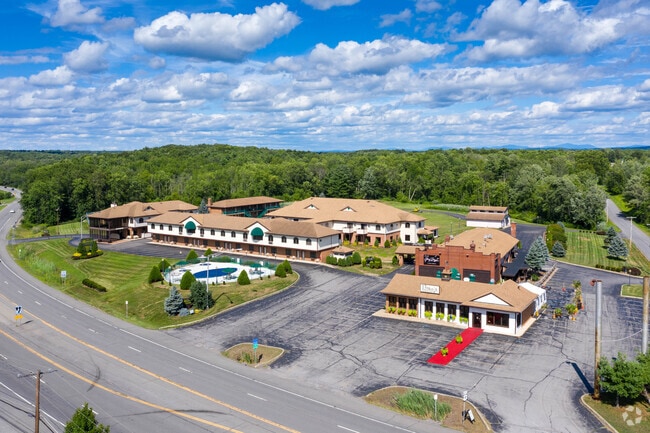
Property Record
2955 Route 9, , NY


Current Lease Availabilities
Hospitality LEASE
$21.60 SF/YR
2,500 SF
Property Detail
2955 Route 9
Albany-Schenectady-Troy, NY
SIDE: E
414089 191.-1-11
SARATOGA
Motel
New York
C8
11.000
2024
14.51 AC
2024
Saratoga Springs
5,576 SF
Albany/Schenectady/Troy
NEARBY LISTINGS FOR SALE OR LEASE
-
-
2955-2961 State Route 9, Ballston Spa, NY 12020
Ballston Spa, NY 12020
$21.60 SF/YR
2,500 SF
Hospitality
-
View all listings for lease on LoopNet.com
DEMOGRAPHICS near 2955 Route 9
1 mile
3 mile
5 mile
2024 Total Population
188
12,143
60,682
2029 Population
196
12,439
62,140
Pop Growth 2024-2029
+ 4.26%
+ 2.44%
+ 2.40%
Average Age
45
44
44
2024 Total Households
73
5,220
27,760
HH Growth 2024-2029
+ 4.11%
+ 2.62%
+ 2.56%
Median Household Inc
$148,610
$107,314
$96,973
Avg Household Size
2.50
2.30
2.10
2024 Avg HH Vehicles
2.00
2.00
2.00
Median Home Value
$511,364
$389,666
$398,673
Median Year Built
1994
1985
1985
Nearby Places
Map Layers
Map Styles
 Street
 Aerial
Transit
 Traffic
 Biking
Places
Listings with unknown addresses are not visible on the map
- Restaurants
- Banks
- Shops
- Fitness
- Groceries
PUBLIC TRANSPORTATION
COMMUTER RAIL
Saratoga Springs Amtrak Station (Adirondack - Amtrak, Ethan Allen Express - Amtrak)
Drive
Walk
Distance
Saratoga Springs Amtrak Station (Adirondack - Amtrak, Ethan Allen Express - Amtrak)
9 min
5.2 mi
AIRPORT
Albany International
Drive
Walk
Distance
Albany International
28 min
21.7 mi
Freight Ports
Albany, NY Port
Drive
Walk
Distance
Albany, NY Port
44 min
32.2 mi
Nearby Properties
Address
Land Use
TOTAL SIZE
Lot Size
Zoning
Address
Land Use
TOTAL SIZE
Lot Size
Zoning
246,647 SF
160.43 AC
INSHT
Address
Land Use
TOTAL SIZE
Lot Size
Zoning
10,322 SF
29.43 AC
PDD
Address
Land Use
TOTAL SIZE
Lot Size
Zoning
2,160 SF
14.67 AC
R1
Address
Land Use
TOTAL SIZE
Lot Size
Zoning
28,437 SF
61.38 AC
INSPR
Address
Land Use
TOTAL SIZE
Lot Size
Zoning
86,475 SF
0.14 AC
PDD
Address
Land Use
TOTAL SIZE
Lot Size
Zoning
361,330 SF
25.15 AC
INDG
Address
Land Use
TOTAL SIZE
Lot Size
Zoning
112,656 SF
21.87 AC
UR1
Address
Land Use
TOTAL SIZE
Lot Size
Zoning
60,270 SF
20 AC
INSED
Address
Land Use
TOTAL SIZE
Lot Size
Zoning
105,772 SF
5.17 AC
C6
Address
Land Use
TOTAL SIZE
Lot Size
Zoning
600 SF
50.28 AC
R3
Address
Land Use
TOTAL SIZE
Lot Size
Zoning
64,505 SF
2.75 AC
C3
Address
Land Use
TOTAL SIZE
Lot Size
Zoning
23,280 SF
25.19 AC
PDD
Address
Land Use
TOTAL SIZE
Lot Size
Zoning
32,344 SF
6.22 AC
PDD
Address
Land Use
TOTAL SIZE
Lot Size
Zoning
5,200 SF
9.49 AC
C6
Address
Land Use
TOTAL SIZE
Lot Size
Zoning
25,292 SF
291.60 AC
C6
Address
Land Use
TOTAL SIZE
Lot Size
Zoning
17,520 SF
4.65 AC
UR4
Address
Land Use
TOTAL SIZE
Lot Size
Zoning
118,085 SF
22.26 AC
INDG
Address
Land Use
TOTAL SIZE
Lot Size
Zoning
216,320 SF
29.15 AC
INDG
Address
Land Use
TOTAL SIZE
Lot Size
Zoning
1,248 SF
10.24 AC
C6
Address
Land Use
TOTAL SIZE
Lot Size
Zoning
832 SF
20 AC
INDG
Address
Land Use
TOTAL SIZE
Lot Size
Zoning
98,064 SF
20.95 AC
INDL
Address
Land Use
TOTAL SIZE
Lot Size
Zoning
283.08 AC
INSPR
Address
Land Use
TOTAL SIZE
Lot Size
Zoning
16,000 SF
165.20 AC
C6
Address
Land Use
TOTAL SIZE
Lot Size
Zoning
7,560 SF
4.25 AC
C6
Address
Land Use
TOTAL SIZE
Lot Size
Zoning
10,563 SF
0.98 AC
C3
Address
Land Use
TOTAL SIZE
Lot Size
Zoning
40,346 SF
10.58 AC
C6
Address
Land Use
TOTAL SIZE
Lot Size
Zoning
19,298 SF
6.07 AC
PDD
Address
Land Use
TOTAL SIZE
Lot Size
Zoning
19,137 SF
12.56 AC
PDD
Address
Land Use
TOTAL SIZE
Lot Size
Zoning
20,310 SF
5.44 AC
C9
The World's #1 Commercial Real Estate Marketplace
Connect with us
© 2026 CoStar Group
The information above has been obtained from sources believed reliable. While we do not doubt its accuracy we have not verified it and make no guarantee, warranty or representation about it. It is your responsibility to independently confirm its accuracy and completeness. Any projections, opinions, assumptions, or estimates used are for example only and do not represent the current or future performance of the property. The value of this transaction to you depends on tax and other factors which should be evaluated by your tax, financial, and legal advisors. You and your advisors should conduct a careful, independent investigation of the property to determine to your satisfaction the suitability of the property for your needs.