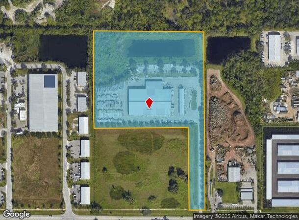
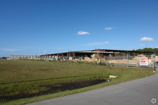
Property Record
2955 Whitfield Ave, Sarasota, FL 34243


NEARBY LISTINGS FOR SALE OR LEASE
Property Detail
2955 Whitfield Ave
18767-0025-9
COM AT THE SW COR OF SEC 20, TWN 35S, RNG 18E; TH ALG THE S LN OF SD SEC 20, S 89 DEG 26 MIN 24 SEC E, 842.90 FT; TH N 00 DEG 00 MIN 00 SEC E, 25.74 FT TO THE NLY MAINTAINED R/W
Warehouse
Manatee
A
Florida
12115C0045F
13.74 AC
2024
Manatee
2025
Tampa/St Petersburg
000805
North Port-Sarasota-Bradenton, FL
72,950 SF
DEMOGRAPHICS near 2955 Whitfield Ave
1 Mile
3 Mile
5 Mile
2024 Total Population
2,377
64,177
185,300
2029 Population
2,772
74,429
214,978
Pop Growth 2024-2029
+ 16.62%
+ 15.97%
+ 16.02%
Average Age
50
46
45
2024 Total Households
1,062
26,895
78,037
HH Growth 2024-2029
+ 15.82%
+ 15.23%
+ 15.39%
Median Household Inc
$76,771
$61,157
$55,638
Avg Household Size
2.20
2.30
2.20
2024 Avg HH Vehicles
2.00
2.00
2.00
Median Home Value
$338,519
$279,014
$248,968
Median Year Built
2003
1989
1984
Nearby Places
Map Layers
Map Styles
 Street
 Aerial
- Restaurants
- Banks
- Shops
- Fitness
- Groceries
PUBLIC TRANSPORTATION
AIRPORT
Sarasota/Bradenton International
DRIVE
WALK
Distance
Sarasota/Bradenton International
12 min
5.4 mi
St Pete-Clearwater International
DRIVE
WALK
Distance
St Pete-Clearwater International
57 min
42.1 mi
Freight Ports
Port Manatee
DRIVE
WALK
Distance
Port Manatee
30 min
18.2 mi
Nearby Properties
Address
Land Use
TOTAL SIZE
Lot Size
Zoning
Address
Land Use
TOTAL SIZE
Lot Size
Zoning
1,023,770 SF
76.55 AC
Address
Land Use
TOTAL SIZE
Lot Size
Zoning
390,439 SF
143.53 AC
AA
Address
Land Use
TOTAL SIZE
Lot Size
Zoning
425,298 SF
25.59 AC
PD-R
Address
Land Use
TOTAL SIZE
Lot Size
Zoning
385,610 SF
32.65 AC
RMF-6 MULT
Address
Land Use
TOTAL SIZE
Lot Size
Zoning
331,241 SF
44.24 AC
Address
Land Use
TOTAL SIZE
Lot Size
Zoning
296,343 SF
26.53 AC
PD-R
Address
Land Use
TOTAL SIZE
Lot Size
Zoning
331,816 SF
574.64 AC
Address
Land Use
TOTAL SIZE
Lot Size
Zoning
296,612 SF
576.25 AC
PD-MU
Address
Land Use
TOTAL SIZE
Lot Size
Zoning
264,317 SF
9.55 AC
PD-MU
Address
Land Use
TOTAL SIZE
Lot Size
Zoning
375,171 SF
20 AC
PD-MU
Address
Land Use
TOTAL SIZE
Lot Size
Zoning
238,774 SF
15.56 AC
A-1 SUBURB
Address
Land Use
TOTAL SIZE
Lot Size
Zoning
115,400 SF
22.55 AC
LM LIGHT M
Address
Land Use
TOTAL SIZE
Lot Size
Zoning
359,950 SF
34.91 AC
LM LIGHT M
Address
Land Use
TOTAL SIZE
Lot Size
Zoning
187,000 SF
8.93 AC
Address
Land Use
TOTAL SIZE
Lot Size
Zoning
179,670 SF
3.51 AC
LM LIGHT M
Address
Land Use
TOTAL SIZE
Lot Size
Zoning
214,350 SF
16.07 AC
LM LIGHT M
Address
Land Use
TOTAL SIZE
Lot Size
Zoning
296,983 SF
34.84 AC
PD-MU
Address
Land Use
TOTAL SIZE
Lot Size
Zoning
163,394 SF
15.49 AC
PD-MU
Address
Land Use
TOTAL SIZE
Lot Size
Zoning
318,009 SF
34.60 AC
LM LIGHT M
Address
Land Use
TOTAL SIZE
Lot Size
Zoning
901,196 SF
48.54 AC
LM LIGHT M
Address
Land Use
TOTAL SIZE
Lot Size
Zoning
271,970 SF
31.11 AC
PD-I
Address
Land Use
TOTAL SIZE
Lot Size
Zoning
145,200 SF
8.66 AC
Address
Land Use
TOTAL SIZE
Lot Size
Zoning
123,398 SF
18.50 AC
RMF2
Address
Land Use
TOTAL SIZE
Lot Size
Zoning
126,505 SF
20 AC
RSF-2
Address
Land Use
TOTAL SIZE
Lot Size
Zoning
112,857 SF
10.12 AC
GC GENERA
Address
Land Use
TOTAL SIZE
Lot Size
Zoning
35,420 SF
68.01 AC
G
Address
Land Use
TOTAL SIZE
Lot Size
Zoning
174,048 SF
22.12 AC
CG
Address
Land Use
TOTAL SIZE
Lot Size
Zoning
124,129 SF
23.29 AC
PDC
Address
Land Use
TOTAL SIZE
Lot Size
Zoning
143,582 SF
14.42 AC
LM LIGHT M
Address
Land Use
TOTAL SIZE
Lot Size
Zoning
104,004 SF
16.23 AC
PD-C
The World's #1 Commercial Real Estate Marketplace
Connect with us
© 2025 CoStar Group
The information above has been obtained from sources believed reliable. While we do not doubt its accuracy we have not verified it and make no guarantee, warranty or representation about it. It is your responsibility to independently confirm its accuracy and completeness. Any projections, opinions, assumptions, or estimates used are for example only and do not represent the current or future performance of the property. The value of this transaction to you depends on tax and other factors which should be evaluated by your tax, financial, and legal advisors. You and your advisors should conduct a careful, independent investigation of the property to determine to your satisfaction the suitability of the property for your needs.