Property Record
29555 Pettibone Rd, Solon, OH 44139
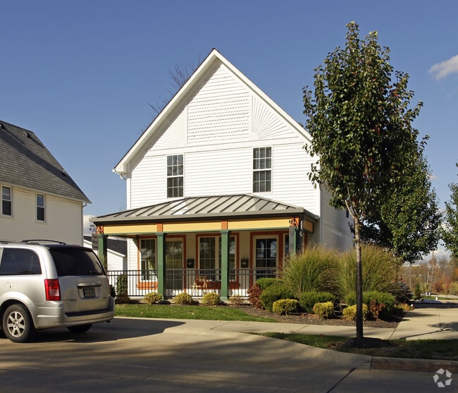

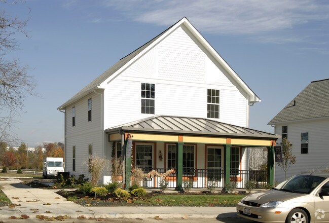
Property Detail
29555 Pettibone Rd
991-22-012
S/L D L VOL 332 PAGE 60-61 AC 3.396 OL 23 2005 S/R GLENWILLOW HISTORIC VILLAGE CENTER SUBD
Miscellaneous
CUYAHOGA
CRL
Ohio
B and X Area of moderate flood hazard, usually the area between the limits of the 100-year and 500-year floods.
3
0
3.40 AC
2025
Southeast
195700
Cleveland
8,192 SF
Cleveland-Elyria, OH
NEARBY LISTINGS FOR SALE OR LEASE
DEMOGRAPHICS near 29555 Pettibone Rd
1 mile
3 mile
5 mile
2025 Total Population
1,908
40,405
98,151
2030 Population
1,897
40,160
97,442
Pop Growth 2025-2030
(0.58%)
(0.61%)
(0.72%)
Average Age
42
43
43
2025 Total Households
681
16,080
40,121
HH Growth 2025-2030
(0.59%)
(0.62%)
(0.76%)
Median Household Inc
$109,218
$95,687
$91,208
Avg Household Size
2.70
2.50
2.40
2025 Avg HH Vehicles
2.00
2.00
2.00
Median Home Value
$324,768
$302,597
$297,538
Median Year Built
1987
1981
1977
Nearby Places
Map Layers
Map Styles
 Street
 Aerial
Layers
 Traffic
 Biking
Places
Listings with unknown addresses are not visible on the map
- Restaurants
- Banks
- Shops
- Fitness
- Groceries
PUBLIC TRANSPORTATION
COMMUTER RAIL
Canal Exploration Center (National Park Scenic Railway - Cuyahoga Valley Scenic Railroad)
Drive
Walk
Distance
Canal Exploration Center (National Park Scenic Railway - Cuyahoga Valley Scenic Railroad)
18 min
8.3 mi
Brecksville (National Park Scenic Railway - Cuyahoga Valley Scenic Railroad)
Drive
Walk
Distance
Brecksville (National Park Scenic Railway - Cuyahoga Valley Scenic Railroad)
22 min
9.8 mi
AIRPORT
Cleveland-Hopkins International
Drive
Walk
Distance
Cleveland-Hopkins International
39 min
25.3 mi
Freight Ports
Port of Toledo
Drive
Walk
Distance
Port of Toledo
153 min
126.2 mi
Nearby Properties
Address
Land Use
TOTAL SIZE
Lot Size
Zoning
Address
Land Use
TOTAL SIZE
Lot Size
Zoning
130,621 SF
67.21 AC
I-2
Address
Land Use
TOTAL SIZE
Lot Size
Zoning
49.31 AC
Address
Land Use
TOTAL SIZE
Lot Size
Zoning
433,283 SF
29.89 AC
Address
Land Use
TOTAL SIZE
Lot Size
Zoning
202,010 SF
90.68 AC
I-2
Address
Land Use
TOTAL SIZE
Lot Size
Zoning
325,774 SF
57.80 AC
Address
Land Use
TOTAL SIZE
Lot Size
Zoning
197,000 SF
42.41 AC
I-2
Address
Land Use
TOTAL SIZE
Lot Size
Zoning
Address
Land Use
TOTAL SIZE
Lot Size
Zoning
246,138 SF
67.82 AC
R-1-C
Address
Land Use
TOTAL SIZE
Lot Size
Zoning
344,806 SF
35.19 AC
R-1-A
Address
Land Use
TOTAL SIZE
Lot Size
Zoning
184,512 SF
5.22 AC
C-1
Address
Land Use
TOTAL SIZE
Lot Size
Zoning
475,568 SF
38.17 AC
IG
Address
Land Use
TOTAL SIZE
Lot Size
Zoning
433,283 SF
40.49 AC
Address
Land Use
TOTAL SIZE
Lot Size
Zoning
109.65 AC
MUD
Address
Land Use
TOTAL SIZE
Lot Size
Zoning
458,000 SF
35.06 AC
IG
Address
Land Use
TOTAL SIZE
Lot Size
Zoning
243,040 SF
9.36 AC
R-3-B
Address
Land Use
TOTAL SIZE
Lot Size
Zoning
32,400 SF
89.36 AC
IG
Address
Land Use
TOTAL SIZE
Lot Size
Zoning
96,632 SF
13.87 AC
R-3
Address
Land Use
TOTAL SIZE
Lot Size
Zoning
30,386 SF
4.63 AC
R-3
Address
Land Use
TOTAL SIZE
Lot Size
Zoning
49,264 SF
13.36 AC
C-3
Address
Land Use
TOTAL SIZE
Lot Size
Zoning
36,686 SF
5.78 AC
R-3
Address
Land Use
TOTAL SIZE
Lot Size
Zoning
29,560 SF
4.46 AC
R-3
Address
Land Use
TOTAL SIZE
Lot Size
Zoning
302,022 SF
19.04 AC
I-2
Address
Land Use
TOTAL SIZE
Lot Size
Zoning
342,068 SF
29.02 AC
Address
Land Use
TOTAL SIZE
Lot Size
Zoning
262,950 SF
26.24 AC
IG
Address
Land Use
TOTAL SIZE
Lot Size
Zoning
20.49 AC
R-1-C
Address
Land Use
TOTAL SIZE
Lot Size
Zoning
37.51 AC
I-2
Address
Land Use
TOTAL SIZE
Lot Size
Zoning
351,911 SF
39.85 AC
I-2
Address
Land Use
TOTAL SIZE
Lot Size
Zoning
247,000 SF
18.44 AC
IG
Address
Land Use
TOTAL SIZE
Lot Size
Zoning
Address
Land Use
TOTAL SIZE
Lot Size
Zoning
90,287 SF
66.28 AC
G-2
The World's #1 Commercial Real Estate Marketplace
Connect with us
© 2026 CoStar Group
The information above has been obtained from sources believed reliable. While we do not doubt its accuracy we have not verified it and make no guarantee, warranty or representation about it. It is your responsibility to independently confirm its accuracy and completeness. Any projections, opinions, assumptions, or estimates used are for example only and do not represent the current or future performance of the property. The value of this transaction to you depends on tax and other factors which should be evaluated by your tax, financial, and legal advisors. You and your advisors should conduct a careful, independent investigation of the property to determine to your satisfaction the suitability of the property for your needs.