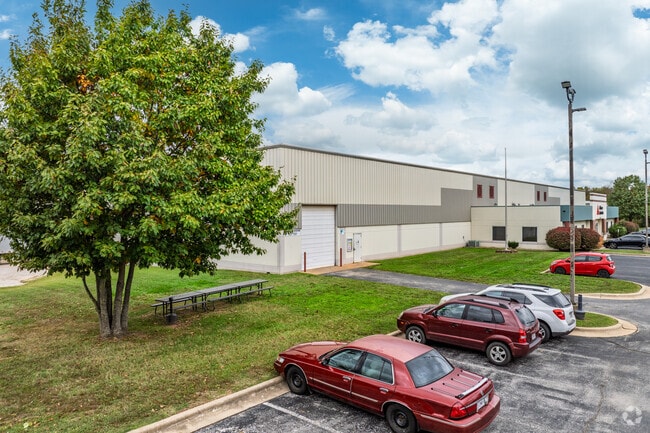
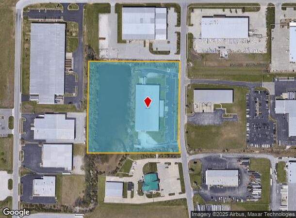
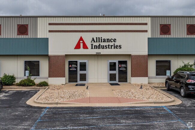
Property Record
2959 N Martin Ave, Springfield, MO 65803
NEARBY LISTINGS FOR SALE OR LEASE
Property Detail
2959 N Martin Ave
Springfield, MO
Martin Investment Services 2Nd Add
12-02-100-038
MARTIN INVESTMENT SERVICES 2ND ADD LOT 2
Warehouse
Greene
X
Missouri
29077C0352E
2
2025
7.85 AC
2025
Northeast
003702
Springfield
46,440 SF
DEMOGRAPHICS near 2959 N Martin Ave
1 Mile
3 Mile
5 Mile
2024 Total Population
116
6,846
49,140
2029 Population
122
7,109
50,981
Pop Growth 2024-2029
+ 5.17%
+ 3.84%
+ 3.75%
Average Age
40
42
40
2024 Total Households
53
2,994
20,942
HH Growth 2024-2029
+ 5.66%
+ 3.91%
+ 3.91%
Median Household Inc
$57,499
$64,956
$50,198
Avg Household Size
2.20
2.20
2.20
2024 Avg HH Vehicles
2.00
2.00
2.00
Median Home Value
$320,000
$306,955
$189,534
Median Year Built
2000
1994
1977
Nearby Places
Map Layers
Map Styles
 Street
 Aerial
- Restaurants
- Banks
- Shops
- Fitness
- Groceries
PUBLIC TRANSPORTATION
AIRPORT
Springfield-Branson Ntl
DRIVE
WALK
Distance
Springfield-Branson Ntl
26 min
16.4 mi
Nearby Properties
Address
Land Use
TOTAL SIZE
Lot Size
Zoning
Address
Land Use
TOTAL SIZE
Lot Size
Zoning
68.92 AC
INC
Address
Land Use
TOTAL SIZE
Lot Size
Zoning
35.56 AC
INC
Address
Land Use
TOTAL SIZE
Lot Size
Zoning
617,990 SF
49.88 AC
INC
Address
Land Use
TOTAL SIZE
Lot Size
Zoning
20.01 AC
Address
Land Use
TOTAL SIZE
Lot Size
Zoning
22.01 AC
INC.
Address
Land Use
TOTAL SIZE
Lot Size
Zoning
1,728,457 SF
123.60 AC
INC
Address
Land Use
TOTAL SIZE
Lot Size
Zoning
37.01 AC
INC
Address
Land Use
TOTAL SIZE
Lot Size
Zoning
349,216 SF
29.46 AC
INC
Address
Land Use
TOTAL SIZE
Lot Size
Zoning
805,370 SF
54.30 AC
INC
Address
Land Use
TOTAL SIZE
Lot Size
Zoning
24.54 AC
INC.
Address
Land Use
TOTAL SIZE
Lot Size
Zoning
1,825 SF
4.31 AC
INC
Address
Land Use
TOTAL SIZE
Lot Size
Zoning
127,740 SF
27.70 AC
INC
Address
Land Use
TOTAL SIZE
Lot Size
Zoning
92,702 SF
42.54 AC
INC
Address
Land Use
TOTAL SIZE
Lot Size
Zoning
110,347 SF
14.58 AC
INC
Address
Land Use
TOTAL SIZE
Lot Size
Zoning
256,172 SF
19.03 AC
INC
Address
Land Use
TOTAL SIZE
Lot Size
Zoning
79.50 AC
INC
Address
Land Use
TOTAL SIZE
Lot Size
Zoning
31.56 AC
INC
Address
Land Use
TOTAL SIZE
Lot Size
Zoning
328,252 SF
18.67 AC
INC
Address
Land Use
TOTAL SIZE
Lot Size
Zoning
32.40 AC
INC
Address
Land Use
TOTAL SIZE
Lot Size
Zoning
16.03 AC
INC
Address
Land Use
TOTAL SIZE
Lot Size
Zoning
11.68 AC
INC
Address
Land Use
TOTAL SIZE
Lot Size
Zoning
70,284 SF
22.88 AC
INC
Address
Land Use
TOTAL SIZE
Lot Size
Zoning
491,910 SF
49.03 AC
INC
Address
Land Use
TOTAL SIZE
Lot Size
Zoning
323,771 SF
31.48 AC
INC
Address
Land Use
TOTAL SIZE
Lot Size
Zoning
5.26 AC
INC
Address
Land Use
TOTAL SIZE
Lot Size
Zoning
7.66 AC
INC
Address
Land Use
TOTAL SIZE
Lot Size
Zoning
176,874 SF
40.18 AC
INC
Address
Land Use
TOTAL SIZE
Lot Size
Zoning
54,952 SF
9.29 AC
INC
Address
Land Use
TOTAL SIZE
Lot Size
Zoning
153,959 SF
19.35 AC
INC
Address
Land Use
TOTAL SIZE
Lot Size
Zoning
5.31 AC
INC
The World's #1 Commercial Real Estate Marketplace
Connect with us
© 2025 CoStar Group
The information above has been obtained from sources believed reliable. While we do not doubt its accuracy we have not verified it and make no guarantee, warranty or representation about it. It is your responsibility to independently confirm its accuracy and completeness. Any projections, opinions, assumptions, or estimates used are for example only and do not represent the current or future performance of the property. The value of this transaction to you depends on tax and other factors which should be evaluated by your tax, financial, and legal advisors. You and your advisors should conduct a careful, independent investigation of the property to determine to your satisfaction the suitability of the property for your needs.