Property Record
2959 Thomasville Rd, Winston Salem, NC 27107


NEARBY LISTINGS FOR SALE OR LEASE
Property Detail
2959 Thomasville Rd
Winston-Salem, NC
Waughtown Two
6844-12-0887
LO:106B BL:1928
Residentialacreage
Forsyth
X
North Carolina
3710684400J
106b
2024
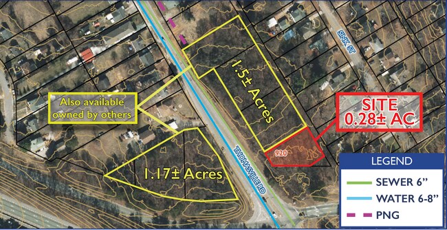
0.28 AC
2025
SE Forsyth County
003404
Greensboro/Winston-Salem
DEMOGRAPHICS near 2959 Thomasville Rd
1 Mile
3 Mile
5 Mile
2024 Total Population
8,587
51,739
135,605
2029 Population
8,947
54,058
141,814
Pop Growth 2024-2029
+ 4.19%
+ 4.48%
+ 4.58%
Average Age
34
35
38
2024 Total Households
2,811
18,984
55,531
HH Growth 2024-2029
+ 4.20%
+ 4.56%
+ 4.67%
Median Household Inc
$29,943
$39,555
$47,620
Avg Household Size
2.80
2.50
2.30
2024 Avg HH Vehicles
2.00
2.00
2.00
Median Home Value
$75,465
$139,613
$171,792
Median Year Built
1956
1973
1975
Nearby Places
Map Layers
Map Styles
 Street
 Aerial
- Restaurants
- Banks
- Shops
- Fitness
- Groceries
PUBLIC TRANSPORTATION
AIRPORT
Piedmont Triad International
DRIVE
WALK
Distance
Piedmont Triad International
29 min
19.0 mi
Freight Ports
Port of Wilmington
DRIVE
WALK
Distance
Port of Wilmington
267 min
227.7 mi
SALE & LEASE HISTORY
LISTING DATE
SALE/LEASE

Jan 16, 2024
For Sale
Nearby Properties
Address
Land Use
TOTAL SIZE
Lot Size
Zoning
Address
Land Use
TOTAL SIZE
Lot Size
Zoning
368,715 SF
4.11 AC
CI
Address
Land Use
TOTAL SIZE
Lot Size
Zoning
315,590 SF
2 AC
CB
Address
Land Use
TOTAL SIZE
Lot Size
Zoning
156,507 SF
NULL
Address
Land Use
TOTAL SIZE
Lot Size
Zoning
100 SF
37.41 AC
C,H
Address
Land Use
TOTAL SIZE
Lot Size
Zoning
162,844 SF
57.77 AC
IP
Address
Land Use
TOTAL SIZE
Lot Size
Zoning
196,804 SF
2.16 AC
CB
Address
Land Use
TOTAL SIZE
Lot Size
Zoning
276,164 SF
27.55 AC
HB
Address
Land Use
TOTAL SIZE
Lot Size
Zoning
109,387 SF
0.58 AC
CB
Address
Land Use
TOTAL SIZE
Lot Size
Zoning
186,776 SF
25.80 AC
IP
Address
Land Use
TOTAL SIZE
Lot Size
Zoning
1,182.87 AC
IP
Address
Land Use
TOTAL SIZE
Lot Size
Zoning
176,680 SF
10.54 AC
MU-S
Address
Land Use
TOTAL SIZE
Lot Size
Zoning
72,145 SF
0.67 AC
CB
Address
Land Use
TOTAL SIZE
Lot Size
Zoning
102,588 SF
13.98 AC
RM18
Address
Land Use
TOTAL SIZE
Lot Size
Zoning
167,500 SF
14.96 AC
GI
Address
Land Use
TOTAL SIZE
Lot Size
Zoning
992,551 SF
72.46 AC
GI
Address
Land Use
TOTAL SIZE
Lot Size
Zoning
415,099 SF
104.61 AC
LI,RS9
Address
Land Use
TOTAL SIZE
Lot Size
Zoning
72,617 SF
13.85 AC
RM18
Address
Land Use
TOTAL SIZE
Lot Size
Zoning
319,873 SF
35.01 AC
GI
Address
Land Use
TOTAL SIZE
Lot Size
Zoning
35,423 SF
1.98 AC
HB
Address
Land Use
TOTAL SIZE
Lot Size
Zoning
188,088 SF
26.83 AC
RM18
Address
Land Use
TOTAL SIZE
Lot Size
Zoning
707,739 SF
60.36 AC
GI
Address
Land Use
TOTAL SIZE
Lot Size
Zoning
469,797 SF
73.87 AC
GI
Address
Land Use
TOTAL SIZE
Lot Size
Zoning
68,010 SF
15.32 AC
IP,RS9
Address
Land Use
TOTAL SIZE
Lot Size
Zoning
101,754 SF
14.50 AC
HB,RM18
Address
Land Use
TOTAL SIZE
Lot Size
Zoning
96,089 SF
14.91 AC
HB-S
Address
Land Use
TOTAL SIZE
Lot Size
Zoning
88,547 SF
1.37 AC
PB-S
Address
Land Use
TOTAL SIZE
Lot Size
Zoning
69,891 SF
1.29 AC
CI
Address
Land Use
TOTAL SIZE
Lot Size
Zoning
74,945 SF
14.80 AC
IP
Address
Land Use
TOTAL SIZE
Lot Size
Zoning
44,748 SF
4.11 AC
GB
Address
Land Use
TOTAL SIZE
Lot Size
Zoning
21,489 SF
4.44 AC
RM18
The World's #1 Commercial Real Estate Marketplace
Connect with us
© 2025 CoStar Group
The information above has been obtained from sources believed reliable. While we do not doubt its accuracy we have not verified it and make no guarantee, warranty or representation about it. It is your responsibility to independently confirm its accuracy and completeness. Any projections, opinions, assumptions, or estimates used are for example only and do not represent the current or future performance of the property. The value of this transaction to you depends on tax and other factors which should be evaluated by your tax, financial, and legal advisors. You and your advisors should conduct a careful, independent investigation of the property to determine to your satisfaction the suitability of the property for your needs.