Property Record
296 S Main St, Sheffield, MA 01257


Save to a Folder
{{folder.Name}}
{{folder.ListingIds.length}} Properties
{{folder.ListingIds.length}} Property
Create a New Folder
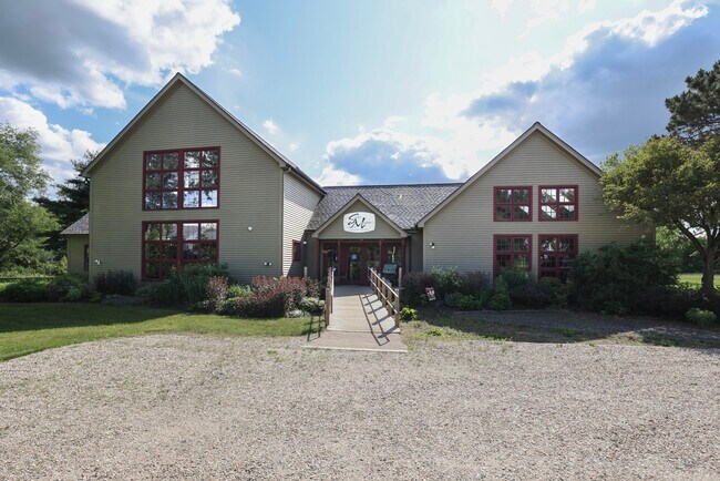
Property Detail
296 S Main St
SHEF-000200-000001-000053
Berkshire
Commercialofficeresidentialmixeduse
Massachusetts
VC
5.3
2025
1.94 AC
2025
Massachusetts North/West Area
926100
Other Market Areas
8,125 SF
Pittsfield, MA
NEARBY LISTINGS FOR SALE OR LEASE
-
-
View all Sheffield listings for sale on LoopNet.com
DEMOGRAPHICS near 296 S Main St
1 mile
3 mile
5 mile
2025 Total Population
502
1,769
4,548
2030 Population
460
1,651
4,363
Pop Growth 2025-2030
(8.37%)
(6.67%)
(4.07%)
Average Age
50
49
47
2025 Total Households
240
802
2,028
HH Growth 2025-2030
(8.33%)
(6.61%)
(3.94%)
Median Household Inc
$89,444
$86,818
$82,217
Avg Household Size
2.10
2.20
2.20
2025 Avg HH Vehicles
2.00
2.00
2.00
Median Home Value
$446,022
$425,751
$407,572
Median Year Built
1965
1957
1959
Nearby Places
Map Layers
Map Styles
 Street
 Aerial
Layers
 Traffic
 Biking
Places
Listings with unknown addresses are not visible on the map
- Restaurants
- Banks
- Shops
- Fitness
- Groceries
PUBLIC TRANSPORTATION
AIRPORT
Bradley International
Drive
Walk
Distance
Bradley International
88 min
46.5 mi
SALE & LEASE HISTORY
LISTING DATE
SALE/LEASE

Sep 20, 2017
For Sale
Jun 29, 2023
For Sale
Jul 23, 2018
For Sale
Nearby Properties
Address
Land Use
TOTAL SIZE
Lot Size
Zoning
Address
Land Use
TOTAL SIZE
Lot Size
Zoning
190,834 SF
85 AC
R1
Address
Land Use
TOTAL SIZE
Lot Size
Zoning
14,853 SF
4.57 AC
VC
Address
Land Use
TOTAL SIZE
Lot Size
Zoning
5,939 SF
5.13 AC
VC
Address
Land Use
TOTAL SIZE
Lot Size
Zoning
11,262 SF
0.23 AC
VC
Address
Land Use
TOTAL SIZE
Lot Size
Zoning
5,648 SF
19.30 AC
R1
Address
Land Use
TOTAL SIZE
Lot Size
Zoning
84,380 SF
7.50 AC
VC
Address
Land Use
TOTAL SIZE
Lot Size
Zoning
3,973 SF
0.75 AC
VC
Address
Land Use
TOTAL SIZE
Lot Size
Zoning
2,812 SF
2.50 AC
R1
Address
Land Use
TOTAL SIZE
Lot Size
Zoning
1,926 SF
135 AC
R1
Address
Land Use
TOTAL SIZE
Lot Size
Zoning
2,152 SF
14.52 AC
R1
Address
Land Use
TOTAL SIZE
Lot Size
Zoning
38,269 SF
4.10 AC
GB
Address
Land Use
TOTAL SIZE
Lot Size
Zoning
6,918 SF
0.88 AC
VC
Address
Land Use
TOTAL SIZE
Lot Size
Zoning
5,440 SF
0.51 AC
VC
Address
Land Use
TOTAL SIZE
Lot Size
Zoning
3,966 SF
3 AC
VC
Address
Land Use
TOTAL SIZE
Lot Size
Zoning
49,005 SF
2.64 AC
C
Address
Land Use
TOTAL SIZE
Lot Size
Zoning
41,155 SF
4 AC
R1
Address
Land Use
TOTAL SIZE
Lot Size
Zoning
4,902 SF
0.61 AC
VC
Address
Land Use
TOTAL SIZE
Lot Size
Zoning
3,416 SF
26 AC
R1
Address
Land Use
TOTAL SIZE
Lot Size
Zoning
2,459 SF
22.40 AC
R1
Address
Land Use
TOTAL SIZE
Lot Size
Zoning
6,000 SF
10 AC
GB
Address
Land Use
TOTAL SIZE
Lot Size
Zoning
9,100 SF
1.70 AC
C
Address
Land Use
TOTAL SIZE
Lot Size
Zoning
1,617 SF
1.90 AC
C
Address
Land Use
TOTAL SIZE
Lot Size
Zoning
8,100 SF
4.21 AC
GB
Address
Land Use
TOTAL SIZE
Lot Size
Zoning
2,256 SF
0.50 AC
VC
Address
Land Use
TOTAL SIZE
Lot Size
Zoning
4,138 SF
1.46 AC
VC
Address
Land Use
TOTAL SIZE
Lot Size
Zoning
9,780 SF
0.41 AC
VC
Address
Land Use
TOTAL SIZE
Lot Size
Zoning
1,590 SF
11.94 AC
R1
Address
Land Use
TOTAL SIZE
Lot Size
Zoning
73.42 AC
R1
Address
Land Use
TOTAL SIZE
Lot Size
Zoning
4,806 SF
3.86 AC
R1
Address
Land Use
TOTAL SIZE
Lot Size
Zoning
11,217 SF
2.44 AC
R1
The World's #1 Commercial Real Estate Marketplace
Connect with us
© 2026 CoStar Group
The information above has been obtained from sources believed reliable. While we do not doubt its accuracy we have not verified it and make no guarantee, warranty or representation about it. It is your responsibility to independently confirm its accuracy and completeness. Any projections, opinions, assumptions, or estimates used are for example only and do not represent the current or future performance of the property. The value of this transaction to you depends on tax and other factors which should be evaluated by your tax, financial, and legal advisors. You and your advisors should conduct a careful, independent investigation of the property to determine to your satisfaction the suitability of the property for your needs.