Property Record
2960 Grit Rd, Hurt, VA 24563
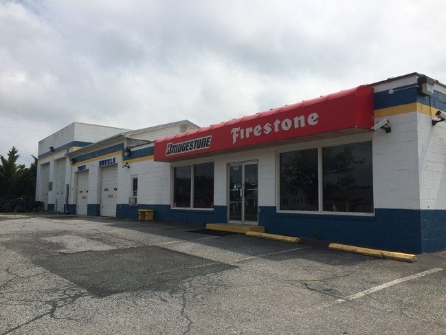
Property Detail
2960 Grit Rd
2565-02-8794
GRIT RD 668 .52AC
Storebuilding
Pittsylvania
B-2
Virginia
B and X Area of moderate flood hazard, usually the area between the limits of the 100-year and 500-year floods.
0.52 AC
2025
Virginia South Central
2025
Other Market Areas
010200
Danville, VA
6,200 SF
NEARBY LISTINGS FOR SALE OR LEASE
DEMOGRAPHICS near 2960 Grit Rd
1 mile
3 mile
5 mile
2025 Total Population
421
3,454
8,338
2030 Population
416
3,419
8,280
Pop Growth 2025-2030
(1.19%)
(1.01%)
(0.70%)
Average Age
48
44
44
2025 Total Households
204
1,555
3,687
HH Growth 2025-2030
(1.47%)
(0.96%)
(0.71%)
Median Household Inc
$49,230
$45,342
$46,904
Avg Household Size
2.00
2.20
2.20
2025 Avg HH Vehicles
3.00
2.00
2.00
Median Home Value
$165,833
$148,286
$145,519
Median Year Built
1977
1971
1970
Nearby Places
Map Layers
Map Styles
 Street
 Aerial
Layers
 Traffic
 Biking
Places
Listings with unknown addresses are not visible on the map
- Restaurants
- Banks
- Shops
- Fitness
- Groceries
PUBLIC TRANSPORTATION
AIRPORT
Lynchburg Regional/Preston Glenn Field
Drive
Walk
Distance
Lynchburg Regional/Preston Glenn Field
40 min
23.2 mi
SALE & LEASE HISTORY
LISTING DATE
SALE/LEASE

Sep 23, 2016
For Sale
Nearby Properties
Address
Land Use
TOTAL SIZE
Lot Size
Zoning
Address
Land Use
TOTAL SIZE
Lot Size
Zoning
6.68 AC
R-1
Address
Land Use
TOTAL SIZE
Lot Size
Zoning
94,228 SF
32.64 AC
Address
Land Use
TOTAL SIZE
Lot Size
Zoning
19.62 AC
TZ
Address
Land Use
TOTAL SIZE
Lot Size
Zoning
70,966 SF
20.51 AC
Address
Land Use
TOTAL SIZE
Lot Size
Zoning
22,714 SF
0.22 AC
Address
Land Use
TOTAL SIZE
Lot Size
Zoning
8,302 SF
18.07 AC
TZ
Address
Land Use
TOTAL SIZE
Lot Size
Zoning
13.90 AC
TZ
Address
Land Use
TOTAL SIZE
Lot Size
Zoning
22,228 SF
0.09 AC
Address
Land Use
TOTAL SIZE
Lot Size
Zoning
59,598 SF
4.07 AC
Address
Land Use
TOTAL SIZE
Lot Size
Zoning
13,373 SF
0.12 AC
TZ
Address
Land Use
TOTAL SIZE
Lot Size
Zoning
31,276 SF
12.70 AC
Address
Land Use
TOTAL SIZE
Lot Size
Zoning
3,747 SF
8.34 AC
R-1
Address
Land Use
TOTAL SIZE
Lot Size
Zoning
10,368 SF
2.79 AC
TZ
Address
Land Use
TOTAL SIZE
Lot Size
Zoning
13,920 SF
3.67 AC
Address
Land Use
TOTAL SIZE
Lot Size
Zoning
16,503 SF
0.20 AC
Address
Land Use
TOTAL SIZE
Lot Size
Zoning
5,100 SF
0.16 AC
Address
Land Use
TOTAL SIZE
Lot Size
Zoning
4,347 SF
1.57 AC
Address
Land Use
TOTAL SIZE
Lot Size
Zoning
9,062 SF
3.95 AC
R-1
Address
Land Use
TOTAL SIZE
Lot Size
Zoning
10,125 SF
0.29 AC
Address
Land Use
TOTAL SIZE
Lot Size
Zoning
6,400 SF
0.58 AC
Address
Land Use
TOTAL SIZE
Lot Size
Zoning
13,096 SF
0.55 AC
Address
Land Use
TOTAL SIZE
Lot Size
Zoning
71,140 SF
5.27 AC
Address
Land Use
TOTAL SIZE
Lot Size
Zoning
3,028 SF
0.09 AC
Address
Land Use
TOTAL SIZE
Lot Size
Zoning
9,189 SF
0.91 AC
Address
Land Use
TOTAL SIZE
Lot Size
Zoning
6,750 SF
0.98 AC
Address
Land Use
TOTAL SIZE
Lot Size
Zoning
2,844 SF
1.11 AC
Address
Land Use
TOTAL SIZE
Lot Size
Zoning
84,332 SF
8.21 AC
TZ
Address
Land Use
TOTAL SIZE
Lot Size
Zoning
7,371 SF
0.21 AC
R-1
Address
Land Use
TOTAL SIZE
Lot Size
Zoning
11,300 SF
1.02 AC
Address
Land Use
TOTAL SIZE
Lot Size
Zoning
5,062 SF
2.05 AC
R-1
The World's #1 Commercial Real Estate Marketplace
Connect with us
© 2026 CoStar Group
The information above has been obtained from sources believed reliable. While we do not doubt its accuracy we have not verified it and make no guarantee, warranty or representation about it. It is your responsibility to independently confirm its accuracy and completeness. Any projections, opinions, assumptions, or estimates used are for example only and do not represent the current or future performance of the property. The value of this transaction to you depends on tax and other factors which should be evaluated by your tax, financial, and legal advisors. You and your advisors should conduct a careful, independent investigation of the property to determine to your satisfaction the suitability of the property for your needs.