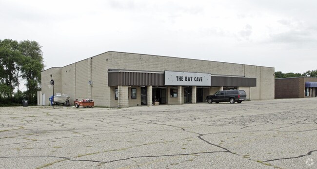
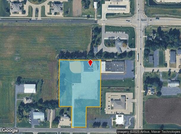
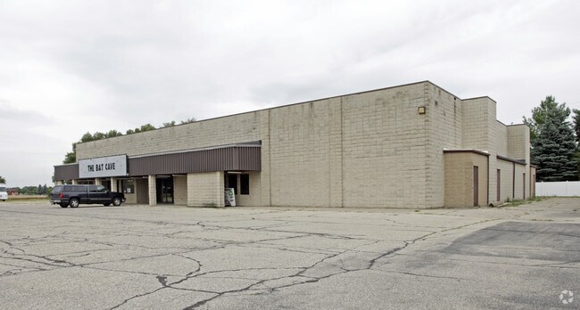
Property Record
2960 S Prairie Ave, Beloit, WI 53511
NEARBY LISTINGS FOR SALE OR LEASE
-
-
View all Beloit listings for sale on LoopNet.com
Property Detail
2960 S Prairie Ave
Janesville-Beloit, WI
Highland Downs Subd
111-059008
PT NE1/4 NE1/4 BELOIT TWP INDUSTRIAL PK #2 LOT 76 & PT OL1 AP CERTIFIED SURVEY MAP #895997 VOL 8 PG 116-118 LOT 1 & ASSESSOR'S PLAT PT OUTLOT 1 DAF: COM NW COR SD CSM, S 449.92', W 123.76', N 450.02', E 122.11' TO POB
Commercialnec
Rock
X
Wisconsin
55105C0317E
76,1
2024
4.81 AC
2024
Rock County
002400
Milwaukee/Madison
1,651 SF
DEMOGRAPHICS near 2960 S Prairie Ave
1 Mile
3 Mile
5 Mile
2024 Total Population
4,941
24,348
53,894
2029 Population
5,011
24,715
54,621
Pop Growth 2024-2029
+ 1.42%
+ 1.51%
+ 1.35%
Average Age
44
41
39
2024 Total Households
2,127
9,870
21,189
HH Growth 2024-2029
+ 1.46%
+ 1.51%
+ 1.43%
Median Household Inc
$66,918
$62,897
$61,262
Avg Household Size
2.20
2.40
2.40
2024 Avg HH Vehicles
2.00
2.00
2.00
Median Home Value
$182,641
$158,610
$143,293
Median Year Built
1982
1967
1962
Nearby Places
Map Layers
Map Styles
 Street
 Aerial
- Restaurants
- Banks
- Shops
- Fitness
- Groceries
PUBLIC TRANSPORTATION
AIRPORT
Chicago/Rockford International
DRIVE
WALK
Distance
Chicago/Rockford International
48 min
36.3 mi
Nearby Properties
Address
Land Use
TOTAL SIZE
Lot Size
Zoning
Address
Land Use
TOTAL SIZE
Lot Size
Zoning
264,000 SF
38.06 AC
Address
Land Use
TOTAL SIZE
Lot Size
Zoning
24.76 AC
Address
Land Use
TOTAL SIZE
Lot Size
Zoning
103,761 SF
21.67 AC
Address
Land Use
TOTAL SIZE
Lot Size
Zoning
7.12 AC
Address
Land Use
TOTAL SIZE
Lot Size
Zoning
90.81 AC
Address
Land Use
TOTAL SIZE
Lot Size
Zoning
13.21 AC
Address
Land Use
TOTAL SIZE
Lot Size
Zoning
231,166 SF
19.25 AC
Address
Land Use
TOTAL SIZE
Lot Size
Zoning
361,947 SF
19.96 AC
Address
Land Use
TOTAL SIZE
Lot Size
Zoning
24.15 AC
Address
Land Use
TOTAL SIZE
Lot Size
Zoning
193,013 SF
22.93 AC
Address
Land Use
TOTAL SIZE
Lot Size
Zoning
38,012 SF
2.74 AC
Address
Land Use
TOTAL SIZE
Lot Size
Zoning
40,800 SF
81.58 AC
Address
Land Use
TOTAL SIZE
Lot Size
Zoning
61,820 SF
3.40 AC
Address
Land Use
TOTAL SIZE
Lot Size
Zoning
27.69 AC
Address
Land Use
TOTAL SIZE
Lot Size
Zoning
10.33 AC
Address
Land Use
TOTAL SIZE
Lot Size
Zoning
30,000 SF
3.31 AC
Address
Land Use
TOTAL SIZE
Lot Size
Zoning
87.39 AC
MHP
Address
Land Use
TOTAL SIZE
Lot Size
Zoning
101,660 SF
10.14 AC
Address
Land Use
TOTAL SIZE
Lot Size
Zoning
16,336 SF
9.06 AC
Address
Land Use
TOTAL SIZE
Lot Size
Zoning
3.30 AC
Address
Land Use
TOTAL SIZE
Lot Size
Zoning
89,678 SF
12.90 AC
Address
Land Use
TOTAL SIZE
Lot Size
Zoning
296,731 SF
22.41 AC
Address
Land Use
TOTAL SIZE
Lot Size
Zoning
11.62 AC
Address
Land Use
TOTAL SIZE
Lot Size
Zoning
30,095 SF
4.24 AC
Address
Land Use
TOTAL SIZE
Lot Size
Zoning
95,546 SF
8.60 AC
Address
Land Use
TOTAL SIZE
Lot Size
Zoning
6.08 AC
Address
Land Use
TOTAL SIZE
Lot Size
Zoning
2.98 AC
Address
Land Use
TOTAL SIZE
Lot Size
Zoning
13.70 AC
Address
Land Use
TOTAL SIZE
Lot Size
Zoning
57,512 SF
1.62 AC
Address
Land Use
TOTAL SIZE
Lot Size
Zoning
76,570 SF
9.58 AC
The World's #1 Commercial Real Estate Marketplace
Connect with us
© 2025 CoStar Group
The information above has been obtained from sources believed reliable. While we do not doubt its accuracy we have not verified it and make no guarantee, warranty or representation about it. It is your responsibility to independently confirm its accuracy and completeness. Any projections, opinions, assumptions, or estimates used are for example only and do not represent the current or future performance of the property. The value of this transaction to you depends on tax and other factors which should be evaluated by your tax, financial, and legal advisors. You and your advisors should conduct a careful, independent investigation of the property to determine to your satisfaction the suitability of the property for your needs.