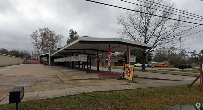
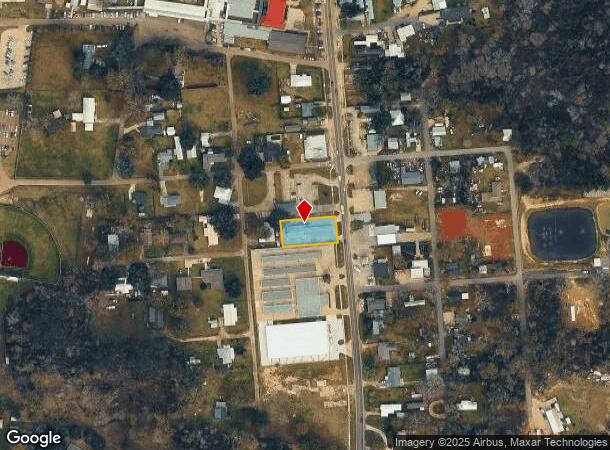
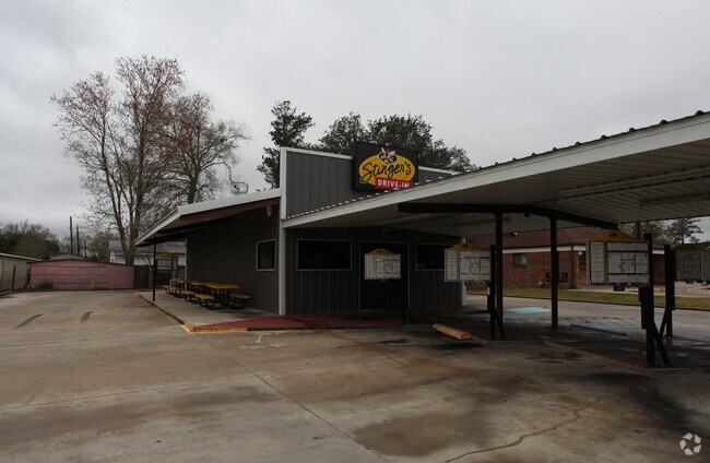
Property Record
29629 S Montpelier Rd, Albany, LA 70711
NEARBY LISTINGS FOR SALE OR LEASE
Property Detail
29629 S Montpelier Rd
Baton Rouge, LA
Not A Subdivision
0291542
A TRACT SEC 40-6-6 MEAS 88 X 173 CONTS .349 OF AN ACRE
Commercialnec
Livingston
X
Louisiana
22063C0300E
0.35 AC
2024
Livingston Parish
2024
Baton Rouge
040101
DEMOGRAPHICS near 29629 S Montpelier Rd
1 Mile
3 Mile
5 Mile
2024 Total Population
1,749
9,496
25,767
2029 Population
1,894
10,249
27,815
Pop Growth 2024-2029
+ 8.29%
+ 7.93%
+ 7.95%
Average Age
38
38
38
2024 Total Households
664
3,632
9,855
HH Growth 2024-2029
+ 8.13%
+ 7.82%
+ 7.88%
Median Household Inc
$64,385
$57,949
$56,414
Avg Household Size
2.60
2.60
2.60
2024 Avg HH Vehicles
2.00
2.00
2.00
Median Home Value
$178,795
$193,200
$204,705
Median Year Built
1987
1988
1991
Nearby Places
Map Layers
Map Styles
 Street
 Aerial
- Restaurants
- Banks
- Shops
- Fitness
- Groceries
PUBLIC TRANSPORTATION
COMMUTER RAIL
Hammond Amtrak Station (City of New Orleans - Amtrak)
DRIVE
WALK
Distance
Hammond Amtrak Station (City of New Orleans - Amtrak)
13 min
7.6 mi
Freight Ports
Port of Greater Baton Rouge
DRIVE
WALK
Distance
Port of Greater Baton Rouge
52 min
41.7 mi
Nearby Properties
Address
Land Use
TOTAL SIZE
Lot Size
Zoning
Address
Land Use
TOTAL SIZE
Lot Size
Zoning
44.92 AC
Address
Land Use
TOTAL SIZE
Lot Size
Zoning
31,920 SF
23.68 AC
Address
Land Use
TOTAL SIZE
Lot Size
Zoning
37.32 AC
Address
Land Use
TOTAL SIZE
Lot Size
Zoning
41,857 SF
16 AC
Address
Land Use
TOTAL SIZE
Lot Size
Zoning
44,320 SF
44.78 AC
Address
Land Use
TOTAL SIZE
Lot Size
Zoning
13.19 AC
Address
Land Use
TOTAL SIZE
Lot Size
Zoning
1.48 AC
Address
Land Use
TOTAL SIZE
Lot Size
Zoning
Address
Land Use
TOTAL SIZE
Lot Size
Zoning
0.23 AC
Address
Land Use
TOTAL SIZE
Lot Size
Zoning
21.72 AC
Address
Land Use
TOTAL SIZE
Lot Size
Zoning
35,975 SF
6.43 AC
Address
Land Use
TOTAL SIZE
Lot Size
Zoning
Address
Land Use
TOTAL SIZE
Lot Size
Zoning
4,200 SF
0.64 AC
Address
Land Use
TOTAL SIZE
Lot Size
Zoning
11,904 SF
2.18 AC
Address
Land Use
TOTAL SIZE
Lot Size
Zoning
5,544 SF
2.30 AC
Address
Land Use
TOTAL SIZE
Lot Size
Zoning
1.10 AC
Address
Land Use
TOTAL SIZE
Lot Size
Zoning
Address
Land Use
TOTAL SIZE
Lot Size
Zoning
3.03 AC
Address
Land Use
TOTAL SIZE
Lot Size
Zoning
8.40 AC
Address
Land Use
TOTAL SIZE
Lot Size
Zoning
4.23 AC
Address
Land Use
TOTAL SIZE
Lot Size
Zoning
1.61 AC
Address
Land Use
TOTAL SIZE
Lot Size
Zoning
Address
Land Use
TOTAL SIZE
Lot Size
Zoning
1.91 AC
Address
Land Use
TOTAL SIZE
Lot Size
Zoning
1.59 AC
Address
Land Use
TOTAL SIZE
Lot Size
Zoning
28.13 AC
Address
Land Use
TOTAL SIZE
Lot Size
Zoning
2,100 SF
0.40 AC
Address
Land Use
TOTAL SIZE
Lot Size
Zoning
9,140 SF
0.93 AC
Address
Land Use
TOTAL SIZE
Lot Size
Zoning
20.39 AC
Address
Land Use
TOTAL SIZE
Lot Size
Zoning
0.97 AC
Address
Land Use
TOTAL SIZE
Lot Size
Zoning
1.01 AC
The World's #1 Commercial Real Estate Marketplace
Connect with us
© 2025 CoStar Group
The information above has been obtained from sources believed reliable. While we do not doubt its accuracy we have not verified it and make no guarantee, warranty or representation about it. It is your responsibility to independently confirm its accuracy and completeness. Any projections, opinions, assumptions, or estimates used are for example only and do not represent the current or future performance of the property. The value of this transaction to you depends on tax and other factors which should be evaluated by your tax, financial, and legal advisors. You and your advisors should conduct a careful, independent investigation of the property to determine to your satisfaction the suitability of the property for your needs.