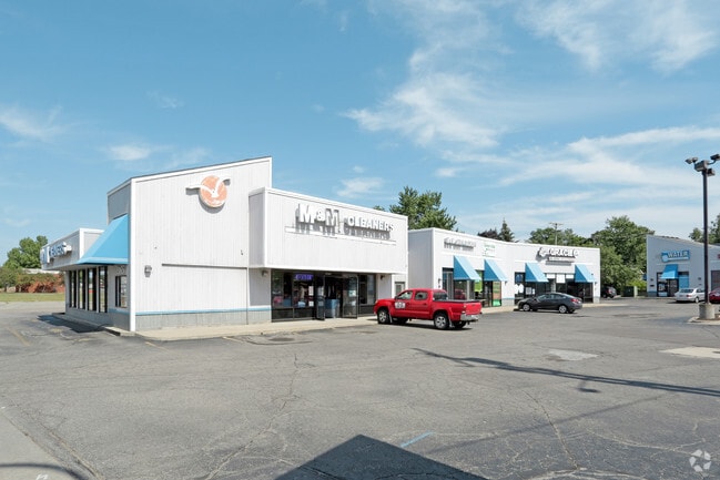
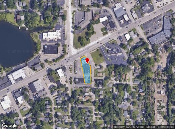
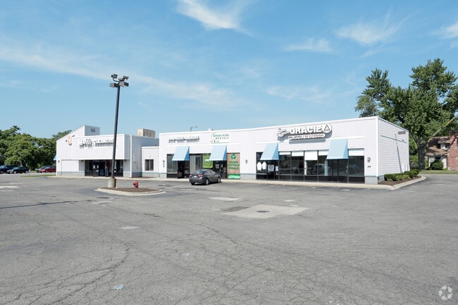
Property Record
2965 Orchard Lake Rd, Keego Harbor, MI 48320
Current Lease Availabilities
NEARBY LISTINGS FOR SALE OR LEASE
Property Detail
2965 Orchard Lake Rd
Detroit-Warren-Dearborn, MI
Keego Harbor Sub
18-01-351-017
T2N, R9E, SEC 1 KEEGO HARBOR SUB LOT 2 EXC THAT PART IN PCL BEG AT PT DIST N 01-22-11 W 1230.31 FT & N 88-37-49 E 44.15 FT & N 00-58-11 W 228.54 FT FROM SW COR OF SEC 1, TH N 00-58-11 W 19.96 FT, TH N 62-38-44 E 109.23 FT, TH S 27-21-16 E 17.71 FT, T
Regionalshoppingcenterormallwithanchorstore
Oakland
X
Michigan
26125C0502F
2
2024
0.43 AC
2024
Lakes Area
154200
Detroit
7,281 SF
DEMOGRAPHICS near 2965 Orchard Lake Rd
1 Mile
3 Mile
5 Mile
2024 Total Population
5,758
54,196
162,415
2029 Population
5,712
54,033
161,677
Pop Growth 2024-2029
(0.80%)
(0.30%)
(0.45%)
Average Age
44
43
42
2024 Total Households
2,722
22,598
65,851
HH Growth 2024-2029
(0.77%)
(0.29%)
(0.45%)
Median Household Inc
$76,351
$76,824
$73,195
Avg Household Size
2.10
2.30
2.40
2024 Avg HH Vehicles
2.00
2.00
2.00
Median Home Value
$336,363
$307,528
$293,973
Median Year Built
1966
1970
1970
Nearby Places
- Restaurants
- Banks
- Shops
- Fitness
- Groceries
PUBLIC TRANSPORTATION
COMMUTER RAIL
DRIVE
WALK
Distance
8 min
3.5 mi
AIRPORT
Detroit Metro Wayne County
DRIVE
WALK
Distance
Detroit Metro Wayne County
55 min
38.1 mi
Bishop International
DRIVE
WALK
Distance
Bishop International
62 min
38.1 mi
Windsor International
DRIVE
WALK
Distance
Windsor International
63 min
41.4 mi
Nearby Properties
Address
Land Use
TOTAL SIZE
Lot Size
Zoning
Address
Land Use
TOTAL SIZE
Lot Size
Zoning
526,398 SF
32.99 AC
Address
Land Use
TOTAL SIZE
Lot Size
Zoning
481,186 SF
42.14 AC
AI
Address
Land Use
TOTAL SIZE
Lot Size
Zoning
374,400 SF
4.10 AC
Address
Land Use
TOTAL SIZE
Lot Size
Zoning
300,934 SF
25.30 AC
AI
Address
Land Use
TOTAL SIZE
Lot Size
Zoning
221,340 SF
26.88 AC
Address
Land Use
TOTAL SIZE
Lot Size
Zoning
156,668 SF
13.19 AC
BI
Address
Land Use
TOTAL SIZE
Lot Size
Zoning
23.28 AC
AI
Address
Land Use
TOTAL SIZE
Lot Size
Zoning
97,172 SF
13.82 AC
BI
Address
Land Use
TOTAL SIZE
Lot Size
Zoning
79,263 SF
22.27 AC
Address
Land Use
TOTAL SIZE
Lot Size
Zoning
145,712 SF
10.51 AC
BV
Address
Land Use
TOTAL SIZE
Lot Size
Zoning
139,227 SF
13.13 AC
BI
Address
Land Use
TOTAL SIZE
Lot Size
Zoning
87,560 SF
7.94 AC
BI
Address
Land Use
TOTAL SIZE
Lot Size
Zoning
288,124 SF
15.76 AC
Address
Land Use
TOTAL SIZE
Lot Size
Zoning
93,706 SF
1.13 AC
Address
Land Use
TOTAL SIZE
Lot Size
Zoning
55,912 SF
1.11 AC
Address
Land Use
TOTAL SIZE
Lot Size
Zoning
143,701 SF
9.85 AC
AI
Address
Land Use
TOTAL SIZE
Lot Size
Zoning
96,587 SF
5 AC
BI
Address
Land Use
TOTAL SIZE
Lot Size
Zoning
137,256 SF
14.97 AC
BI
Address
Land Use
TOTAL SIZE
Lot Size
Zoning
50,927 SF
145.83 AC
Address
Land Use
TOTAL SIZE
Lot Size
Zoning
64,053 SF
2.69 AC
Address
Land Use
TOTAL SIZE
Lot Size
Zoning
55,269 SF
5.40 AC
BI
Address
Land Use
TOTAL SIZE
Lot Size
Zoning
102,042 SF
7.07 AC
AI
Address
Land Use
TOTAL SIZE
Lot Size
Zoning
53,848 SF
1.54 AC
BI
Address
Land Use
TOTAL SIZE
Lot Size
Zoning
34,252 SF
8.27 AC
BI
Address
Land Use
TOTAL SIZE
Lot Size
Zoning
210,350 SF
32.38 AC
BI
Address
Land Use
TOTAL SIZE
Lot Size
Zoning
65,034 SF
10.28 AC
AI
Address
Land Use
TOTAL SIZE
Lot Size
Zoning
31,593 SF
2.92 AC
BI
Address
Land Use
TOTAL SIZE
Lot Size
Zoning
27,455 SF
2.93 AC
BI
Address
Land Use
TOTAL SIZE
Lot Size
Zoning
43,605 SF
6.47 AC
BI
Address
Land Use
TOTAL SIZE
Lot Size
Zoning
124,185 SF
6.25 AC
AI
The World's #1 Commercial Real Estate Marketplace
Connect with us
© 2025 CoStar Group
The information above has been obtained from sources believed reliable. While we do not doubt its accuracy we have not verified it and make no guarantee, warranty or representation about it. It is your responsibility to independently confirm its accuracy and completeness. Any projections, opinions, assumptions, or estimates used are for example only and do not represent the current or future performance of the property. The value of this transaction to you depends on tax and other factors which should be evaluated by your tax, financial, and legal advisors. You and your advisors should conduct a careful, independent investigation of the property to determine to your satisfaction the suitability of the property for your needs.