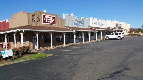
Property Record
2966 State Highway 49, Cool, CA 95614

Property Detail
2966 State Highway 49
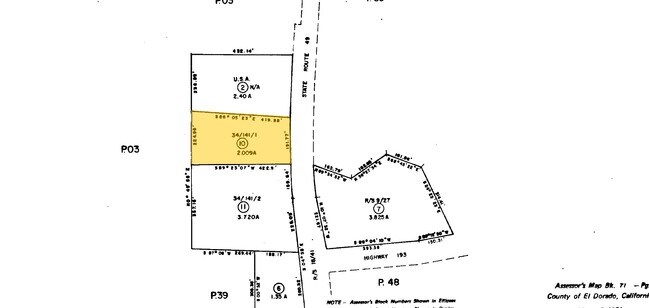
071-080-010-000
PM 34/141/1
Storebuilding
El Dorado
C
California
B and X Area of moderate flood hazard, usually the area between the limits of the 100-year and 500-year floods.
2.01 AC
2024
Outer El Dorado Cnty
2025
Sacramento
030601
Sacramento-Roseville-Folsom, CA
7,000 SF
NEARBY LISTINGS FOR SALE OR LEASE
DEMOGRAPHICS near 2966 State Highway 49
1 mile
3 mile
5 mile
2025 Total Population
284
5,937
27,533
2030 Population
275
6,026
28,427
Pop Growth 2025-2030
(3.17%)
+ 1.50%
+ 3.25%
Average Age
49
46
46
2025 Total Households
117
2,603
11,798
HH Growth 2025-2030
(2.56%)
+ 1.77%
+ 3.35%
Median Household Inc
$136,458
$97,771
$85,196
Avg Household Size
2.40
2.30
2.30
2025 Avg HH Vehicles
2.00
2.00
2.00
Median Home Value
$520,408
$635,199
$649,021
Median Year Built
1987
1982
1980
Nearby Places
Map Layers
Map Styles
 Street
 Aerial
Transit
 Traffic
 Biking
Places
Listings with unknown addresses are not visible on the map
- Restaurants
- Banks
- Shops
- Fitness
- Groceries
PUBLIC TRANSPORTATION
COMMUTER RAIL
Drive
Walk
Distance
16 min
6.9 mi
Drive
Walk
Distance
17 min
6.9 mi
AIRPORT
Sacramento International
Drive
Walk
Distance
Sacramento International
65 min
46.6 mi
SALE & LEASE HISTORY
LISTING DATE
SALE/LEASE

Dec 12, 2017
For Sale
Nearby Properties
Address
Land Use
TOTAL SIZE
Lot Size
Zoning
Address
Land Use
TOTAL SIZE
Lot Size
Zoning
186.30 AC
FBX
Address
Land Use
TOTAL SIZE
Lot Size
Zoning
8,856 SF
0.52 AC
Address
Land Use
TOTAL SIZE
Lot Size
Zoning
165.10 AC
FBX
Address
Land Use
TOTAL SIZE
Lot Size
Zoning
46,267 SF
3.15 AC
RM
Address
Land Use
TOTAL SIZE
Lot Size
Zoning
25,644 SF
2.61 AC
CG
Address
Land Use
TOTAL SIZE
Lot Size
Zoning
17,424 SF
0.66 AC
Address
Land Use
TOTAL SIZE
Lot Size
Zoning
9,100 SF
1.69 AC
CG
Address
Land Use
TOTAL SIZE
Lot Size
Zoning
12,084 SF
0.59 AC
Address
Land Use
TOTAL SIZE
Lot Size
Zoning
9,192 SF
0.65 AC
Address
Land Use
TOTAL SIZE
Lot Size
Zoning
330.60 AC
FBX
Address
Land Use
TOTAL SIZE
Lot Size
Zoning
37,117 SF
2 AC
Address
Land Use
TOTAL SIZE
Lot Size
Zoning
24,003 SF
0.20 AC
Address
Land Use
TOTAL SIZE
Lot Size
Zoning
38,835 SF
0.53 AC
Address
Land Use
TOTAL SIZE
Lot Size
Zoning
15,224 SF
0.91 AC
Address
Land Use
TOTAL SIZE
Lot Size
Zoning
12,103 SF
3.72 AC
C
Address
Land Use
TOTAL SIZE
Lot Size
Zoning
6,841 SF
1 AC
Address
Land Use
TOTAL SIZE
Lot Size
Zoning
8,462 SF
0.43 AC
Address
Land Use
TOTAL SIZE
Lot Size
Zoning
29,208 SF
0.68 AC
Address
Land Use
TOTAL SIZE
Lot Size
Zoning
2,807 SF
4.50 AC
R2A
Address
Land Use
TOTAL SIZE
Lot Size
Zoning
4,400 SF
0.73 AC
CG
Address
Land Use
TOTAL SIZE
Lot Size
Zoning
2,176 SF
0.78 AC
Address
Land Use
TOTAL SIZE
Lot Size
Zoning
11,394 SF
1.10 AC
Address
Land Use
TOTAL SIZE
Lot Size
Zoning
5,688 SF
0.35 AC
Address
Land Use
TOTAL SIZE
Lot Size
Zoning
6,214 SF
0.27 AC
Address
Land Use
TOTAL SIZE
Lot Size
Zoning
8,658 SF
0.66 AC
Address
Land Use
TOTAL SIZE
Lot Size
Zoning
4,682 SF
0.11 AC
Address
Land Use
TOTAL SIZE
Lot Size
Zoning
10,244 SF
0.46 AC
Address
Land Use
TOTAL SIZE
Lot Size
Zoning
244.45 AC
RE
Address
Land Use
TOTAL SIZE
Lot Size
Zoning
6,574 SF
1.86 AC
CG
Address
Land Use
TOTAL SIZE
Lot Size
Zoning
13,875 SF
0.57 AC
The World's #1 Commercial Real Estate Marketplace
Connect with us
© 2026 CoStar Group
The information above has been obtained from sources believed reliable. While we do not doubt its accuracy we have not verified it and make no guarantee, warranty or representation about it. It is your responsibility to independently confirm its accuracy and completeness. Any projections, opinions, assumptions, or estimates used are for example only and do not represent the current or future performance of the property. The value of this transaction to you depends on tax and other factors which should be evaluated by your tax, financial, and legal advisors. You and your advisors should conduct a careful, independent investigation of the property to determine to your satisfaction the suitability of the property for your needs.