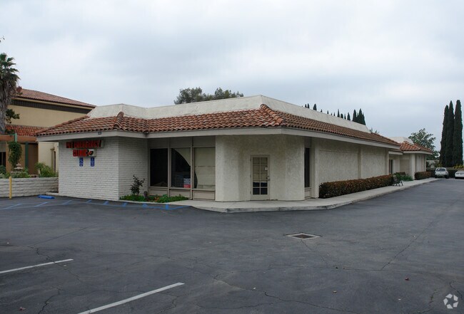
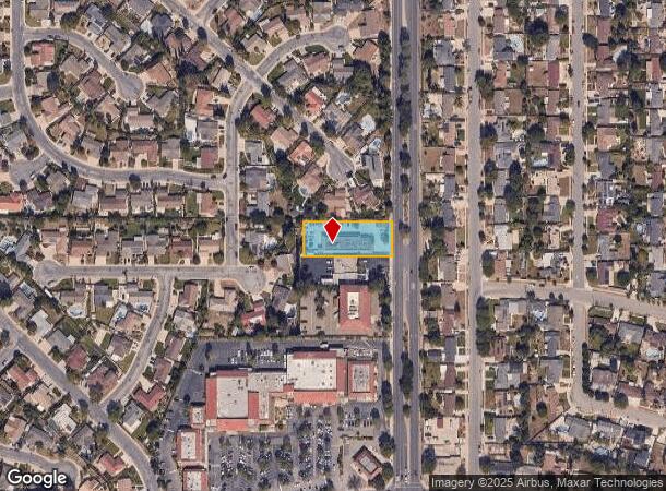
Property Record
2967 N Moorpark Rd, Thousand Oaks, CA 91360

NEARBY LISTINGS FOR SALE OR LEASE
Property Detail
2967 N Moorpark Rd
521-0-070-040
Rancho El Conejo
Medicalbuilding
TWP 02N RGE 19W SEC 33 QTR NE4
X
Ventura
06111C0980E
California
2024
0.66 AC
2025
Thousand Oaks/SE County
006302
Los Angeles
5,870 SF
Oxnard-Thousand Oaks-Ventura, CA
DEMOGRAPHICS near 2967 N Moorpark Rd
1 Mile
3 Mile
5 Mile
2024 Total Population
15,100
65,940
141,053
2029 Population
14,862
65,132
139,025
Pop Growth 2024-2029
(1.58%)
(1.23%)
(1.44%)
Average Age
43
43
42
2024 Total Households
4,903
23,459
50,309
HH Growth 2024-2029
(1.55%)
(1.26%)
(1.53%)
Median Household Inc
$110,375
$116,823
$119,146
Avg Household Size
2.70
2.70
2.70
2024 Avg HH Vehicles
2.00
2.00
2.00
Median Home Value
$753,419
$820,522
$803,654
Median Year Built
1971
1976
1980
Nearby Places
Map Layers
Map Styles
 Street
 Aerial
- Restaurants
- Banks
- Shops
- Fitness
- Groceries
PUBLIC TRANSPORTATION
COMMUTER RAIL
Moorpark (Ventura County Line - Southern California Regional Rail Authority (Metrolink))
DRIVE
WALK
Distance
Moorpark (Ventura County Line - Southern California Regional Rail Authority (Metrolink))
12 min
6.4 mi
AIRPORT
Bob Hope
DRIVE
WALK
Distance
Bob Hope
48 min
36.0 mi
Freight Ports
The Port of Hueneme
DRIVE
WALK
Distance
The Port of Hueneme
37 min
25.0 mi
SALE & LEASE HISTORY
LISTING DATE
SALE/LEASE

Jan 24, 2019
For Lease
Nearby Properties
Address
Land Use
TOTAL SIZE
Lot Size
Zoning
Address
Land Use
TOTAL SIZE
Lot Size
Zoning
13.12 AC
PL
Address
Land Use
TOTAL SIZE
Lot Size
Zoning
4,950 SF
50.22 AC
Address
Land Use
TOTAL SIZE
Lot Size
Zoning
Address
Land Use
TOTAL SIZE
Lot Size
Zoning
384,742 SF
19.93 AC
RPD2
Address
Land Use
TOTAL SIZE
Lot Size
Zoning
199,586 SF
8.95 AC
RPD25
Address
Land Use
TOTAL SIZE
Lot Size
Zoning
15,596 SF
3.17 AC
C2
Address
Land Use
TOTAL SIZE
Lot Size
Zoning
182,756 SF
8.88 AC
RPD1
Address
Land Use
TOTAL SIZE
Lot Size
Zoning
162,078 SF
9.05 AC
R3
Address
Land Use
TOTAL SIZE
Lot Size
Zoning
10.32 AC
PL
Address
Land Use
TOTAL SIZE
Lot Size
Zoning
27.54 AC
PL
Address
Land Use
TOTAL SIZE
Lot Size
Zoning
135.43 AC
Address
Land Use
TOTAL SIZE
Lot Size
Zoning
6.93 AC
PL
Address
Land Use
TOTAL SIZE
Lot Size
Zoning
26,654 SF
17.84 AC
C3
Address
Land Use
TOTAL SIZE
Lot Size
Zoning
127,196 SF
10.18 AC
MULT
Address
Land Use
TOTAL SIZE
Lot Size
Zoning
206,886 SF
12.11 AC
Address
Land Use
TOTAL SIZE
Lot Size
Zoning
5.08 AC
PL
Address
Land Use
TOTAL SIZE
Lot Size
Zoning
89,664 SF
5.03 AC
R-3
Address
Land Use
TOTAL SIZE
Lot Size
Zoning
123,248 SF
8.70 AC
RPD2
Address
Land Use
TOTAL SIZE
Lot Size
Zoning
73,565 SF
5.27 AC
MULT
Address
Land Use
TOTAL SIZE
Lot Size
Zoning
21,878 SF
8.22 AC
C4
Address
Land Use
TOTAL SIZE
Lot Size
Zoning
87,811 SF
4.22 AC
R3
Address
Land Use
TOTAL SIZE
Lot Size
Zoning
12,244 SF
77.34 AC
M1
Address
Land Use
TOTAL SIZE
Lot Size
Zoning
4,731 SF
5.01 AC
Address
Land Use
TOTAL SIZE
Lot Size
Zoning
11,907 SF
6.11 AC
Address
Land Use
TOTAL SIZE
Lot Size
Zoning
17,472 SF
8.30 AC
Address
Land Use
TOTAL SIZE
Lot Size
Zoning
Address
Land Use
TOTAL SIZE
Lot Size
Zoning
10.40 AC
Address
Land Use
TOTAL SIZE
Lot Size
Zoning
13,122 SF
12.62 AC
C-3-
Address
Land Use
TOTAL SIZE
Lot Size
Zoning
176,634 SF
9.73 AC
RPD25
Address
Land Use
TOTAL SIZE
Lot Size
Zoning
59,713 SF
6.53 AC
C3H
The World's #1 Commercial Real Estate Marketplace
Connect with us
© 2025 CoStar Group
The information above has been obtained from sources believed reliable. While we do not doubt its accuracy we have not verified it and make no guarantee, warranty or representation about it. It is your responsibility to independently confirm its accuracy and completeness. Any projections, opinions, assumptions, or estimates used are for example only and do not represent the current or future performance of the property. The value of this transaction to you depends on tax and other factors which should be evaluated by your tax, financial, and legal advisors. You and your advisors should conduct a careful, independent investigation of the property to determine to your satisfaction the suitability of the property for your needs.