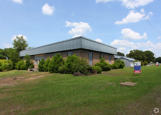
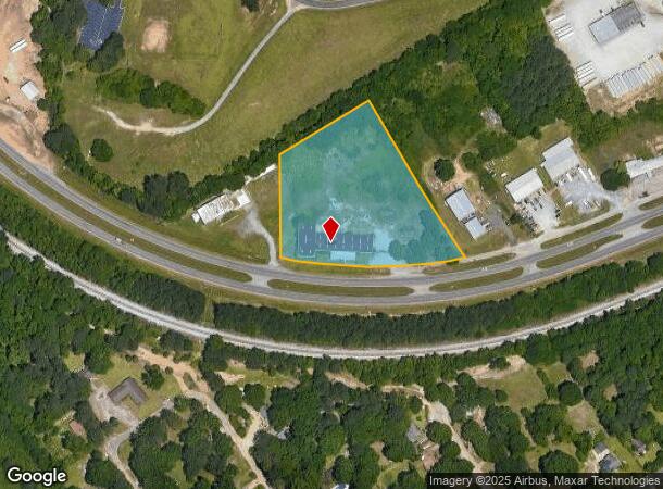
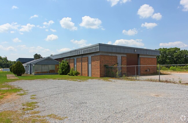
Property Record
2968 Birmingham Hwy, Montgomery, AL 36108
NEARBY LISTINGS FOR SALE OR LEASE
Property Detail
2968 Birmingham Hwy
Montgomery, AL
Tom Crews Plat 1
11-05-16-2-001-012.001
1105162001012001
Recreationalentertainmentgeneral
Montgomery
AE
Alabama
01101C0201J
1,2
2025
4.24 AC
2025
South Montgomery
003000
Montgomery
15,711 SF
DEMOGRAPHICS near 2968 Birmingham Hwy
1 Mile
3 Mile
5 Mile
2024 Total Population
1,302
16,462
51,095
2029 Population
1,347
16,996
51,705
Pop Growth 2024-2029
+ 3.46%
+ 3.24%
+ 1.19%
Average Age
38
38
39
2024 Total Households
494
6,475
20,360
HH Growth 2024-2029
+ 3.24%
+ 3.75%
+ 1.54%
Median Household Inc
$29,367
$23,421
$30,967
Avg Household Size
2.50
2.20
2.20
2024 Avg HH Vehicles
2.00
1.00
1.00
Median Home Value
$62,682
$72,234
$79,330
Median Year Built
1991
1971
1964
Nearby Places
Map Layers
Map Styles
 Street
 Aerial
- Restaurants
- Banks
- Shops
- Fitness
- Groceries
PUBLIC TRANSPORTATION
AIRPORT
Montgomery Regional (Dannelly Field)
DRIVE
WALK
Distance
Montgomery Regional (Dannelly Field)
13 min
8.9 mi
Freight Ports
Port of Mobile
DRIVE
WALK
Distance
Port of Mobile
185 min
169.1 mi
SALE & LEASE HISTORY
LISTING DATE
SALE/LEASE

Sep 25, 2016
For Lease
Sep 24, 2016
For Sale
Nearby Properties
Address
Land Use
TOTAL SIZE
Lot Size
Zoning
Address
Land Use
TOTAL SIZE
Lot Size
Zoning
162 AC
INST
Address
Land Use
TOTAL SIZE
Lot Size
Zoning
193,544 SF
20.33 AC
M-3
Address
Land Use
TOTAL SIZE
Lot Size
Zoning
7,928 SF
2.39 AC
R-60-D
Address
Land Use
TOTAL SIZE
Lot Size
Zoning
88,994 SF
5.16 AC
INST
Address
Land Use
TOTAL SIZE
Lot Size
Zoning
18,035 SF
14 AC
INST
Address
Land Use
TOTAL SIZE
Lot Size
Zoning
28,461 SF
5.20 AC
M-3
Address
Land Use
TOTAL SIZE
Lot Size
Zoning
105 AC
INST
Address
Land Use
TOTAL SIZE
Lot Size
Zoning
26,633 SF
21.50 AC
Address
Land Use
TOTAL SIZE
Lot Size
Zoning
40,917 SF
5.55 AC
M-1
Address
Land Use
TOTAL SIZE
Lot Size
Zoning
87,906 SF
63 AC
M-3
Address
Land Use
TOTAL SIZE
Lot Size
Zoning
4,801 SF
22.72 AC
M-3
Address
Land Use
TOTAL SIZE
Lot Size
Zoning
84 AC
INST
Address
Land Use
TOTAL SIZE
Lot Size
Zoning
161,902 SF
7.20 AC
M-3
Address
Land Use
TOTAL SIZE
Lot Size
Zoning
30,658 SF
0.50 AC
R-60-D
Address
Land Use
TOTAL SIZE
Lot Size
Zoning
51,207 SF
12.90 AC
M-3
Address
Land Use
TOTAL SIZE
Lot Size
Zoning
51,597 SF
5.21 AC
Address
Land Use
TOTAL SIZE
Lot Size
Zoning
75.90 AC
M-1
Address
Land Use
TOTAL SIZE
Lot Size
Zoning
16,912 SF
6.53 AC
M-3
Address
Land Use
TOTAL SIZE
Lot Size
Zoning
16,484 SF
0.83 AC
R-60-D
Address
Land Use
TOTAL SIZE
Lot Size
Zoning
108,677 SF
17 AC
M-3
Address
Land Use
TOTAL SIZE
Lot Size
Zoning
62,850 SF
5.50 AC
M-1
Address
Land Use
TOTAL SIZE
Lot Size
Zoning
141,036 SF
5.26 AC
M-3
Address
Land Use
TOTAL SIZE
Lot Size
Zoning
7,920 SF
2.06 AC
R-60-D
Address
Land Use
TOTAL SIZE
Lot Size
Zoning
124,896 SF
5 AC
M-3
Address
Land Use
TOTAL SIZE
Lot Size
Zoning
7,916 SF
3.25 AC
R-60-D
Address
Land Use
TOTAL SIZE
Lot Size
Zoning
44,501 SF
23.80 AC
INST
Address
Land Use
TOTAL SIZE
Lot Size
Zoning
11,782 SF
29.10 AC
M-3
Address
Land Use
TOTAL SIZE
Lot Size
Zoning
12.97 AC
M-3
Address
Land Use
TOTAL SIZE
Lot Size
Zoning
2,543 SF
35.68 AC
M-3
Address
Land Use
TOTAL SIZE
Lot Size
Zoning
2,304 SF
4.70 AC
FH
The World's #1 Commercial Real Estate Marketplace
Connect with us
© 2026 CoStar Group
The information above has been obtained from sources believed reliable. While we do not doubt its accuracy we have not verified it and make no guarantee, warranty or representation about it. It is your responsibility to independently confirm its accuracy and completeness. Any projections, opinions, assumptions, or estimates used are for example only and do not represent the current or future performance of the property. The value of this transaction to you depends on tax and other factors which should be evaluated by your tax, financial, and legal advisors. You and your advisors should conduct a careful, independent investigation of the property to determine to your satisfaction the suitability of the property for your needs.