Property Record
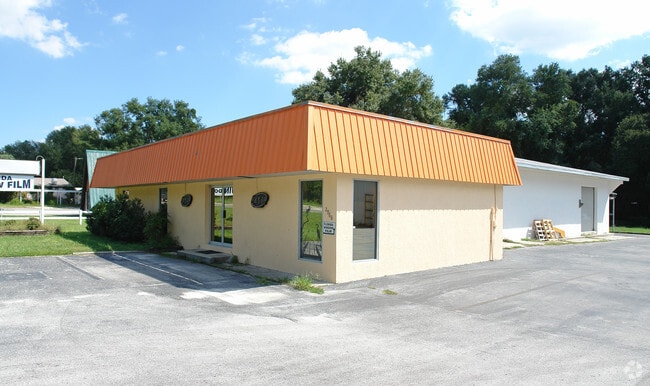
2968 W Gulf To Lake Hwy, Lecanto, FL 34461


NEARBY LISTINGS FOR SALE OR LEASE
-
-
View all Lecanto listings for lease on LoopNet.com
Property Detail
2968 W Gulf To Lake Hwy
Homosassa Springs, FL
Lecanto 1St Addition
18E-19S-04-0110-00040-0020
1ST ADD TO LECANTO LOTS 2 3 4 5 6 & 7 BLK 4 ---&--- AS DESC IN OR BK 800 PG 1792 RES 88-146: PT OF VAC W CHURCH ST ---&--- EXC RDWAY DESC IN OR BK 1037 PG 1165 (3-19-18 90000-1050)
Autorepair
Citrus
X
Florida
12017C0326D
2
2024
1.15 AC
2025
Florida Central North Area
451400
Other Market Areas
10,590 SF
DEMOGRAPHICS near 2968 W Gulf To Lake Hwy
1 Mile
3 Mile
5 Mile
2024 Total Population
724
7,532
35,784
2029 Population
817
8,477
40,401
Pop Growth 2024-2029
+ 12.85%
+ 12.55%
+ 12.90%
Average Age
47
54
53
2024 Total Households
251
3,271
15,818
HH Growth 2024-2029
+ 12.75%
+ 12.26%
+ 12.65%
Median Household Inc
$53,750
$54,819
$49,561
Avg Household Size
2.30
2.10
2.10
2024 Avg HH Vehicles
2.00
2.00
2.00
Median Home Value
$230,921
$259,014
$224,953
Median Year Built
1989
1993
1989
Nearby Places
Map Layers
Map Styles
 Street
 Aerial
- Restaurants
- Banks
- Shops
- Fitness
- Groceries
SALE & LEASE HISTORY
LISTING DATE
SALE/LEASE

Jan 22, 2018
For Sale
Feb 28, 2018
For Lease
Nearby Properties
Address
Land Use
TOTAL SIZE
Lot Size
Zoning
Address
Land Use
TOTAL SIZE
Lot Size
Zoning
982,616 SF
202.47 AC
PSI
Address
Land Use
TOTAL SIZE
Lot Size
Zoning
198,657 SF
73.75 AC
PSI
Address
Land Use
TOTAL SIZE
Lot Size
Zoning
405,045 SF
18.52 AC
PSI
Address
Land Use
TOTAL SIZE
Lot Size
Zoning
113,920 SF
38.95 AC
PSI
Address
Land Use
TOTAL SIZE
Lot Size
Zoning
135,334 SF
11.45 AC
GNC
Address
Land Use
TOTAL SIZE
Lot Size
Zoning
901,824 SF
14.37 AC
GNC
Address
Land Use
TOTAL SIZE
Lot Size
Zoning
198,628 SF
18.19 AC
LDRMH
Address
Land Use
TOTAL SIZE
Lot Size
Zoning
1,549.95 AC
CON
Address
Land Use
TOTAL SIZE
Lot Size
Zoning
42,396 SF
20.02 AC
PSI
Address
Land Use
TOTAL SIZE
Lot Size
Zoning
84,896 SF
23.49 AC
PSI
Address
Land Use
TOTAL SIZE
Lot Size
Zoning
57,652 SF
11.85 AC
GNC
Address
Land Use
TOTAL SIZE
Lot Size
Zoning
345,488 SF
5.87 AC
PDR
Address
Land Use
TOTAL SIZE
Lot Size
Zoning
55,949 SF
4.71 AC
GNC
Address
Land Use
TOTAL SIZE
Lot Size
Zoning
214,450 SF
9.18 AC
GNC
Address
Land Use
TOTAL SIZE
Lot Size
Zoning
42,134 SF
4.52 AC
GNC
Address
Land Use
TOTAL SIZE
Lot Size
Zoning
78,432 SF
18.88 AC
PSI
Address
Land Use
TOTAL SIZE
Lot Size
Zoning
36,430 SF
14.26 AC
GNC
Address
Land Use
TOTAL SIZE
Lot Size
Zoning
5,526 SF
4.72 AC
GNC
Address
Land Use
TOTAL SIZE
Lot Size
Zoning
20,492 SF
2.61 AC
GNC
Address
Land Use
TOTAL SIZE
Lot Size
Zoning
23,540 SF
8.97 AC
PSO
Address
Land Use
TOTAL SIZE
Lot Size
Zoning
47,636 SF
8.67 AC
PSO
Address
Land Use
TOTAL SIZE
Lot Size
Zoning
15.12 AC
GNC
Address
Land Use
TOTAL SIZE
Lot Size
Zoning
6,807 SF
3.64 AC
GNC
Address
Land Use
TOTAL SIZE
Lot Size
Zoning
33,638 SF
40.09 AC
PSI
Address
Land Use
TOTAL SIZE
Lot Size
Zoning
130,776 SF
15.64 AC
GNC
Address
Land Use
TOTAL SIZE
Lot Size
Zoning
18,714 SF
2.62 AC
PSI
Address
Land Use
TOTAL SIZE
Lot Size
Zoning
76,900 SF
4.33 AC
GNC
Address
Land Use
TOTAL SIZE
Lot Size
Zoning
76,959 SF
4.67 AC
GNC
Address
Land Use
TOTAL SIZE
Lot Size
Zoning
11.44 AC
GNC
Address
Land Use
TOTAL SIZE
Lot Size
Zoning
16,223 SF
2.29 AC
GNC
The World's #1 Commercial Real Estate Marketplace
Connect with us
© 2025 CoStar Group
The information above has been obtained from sources believed reliable. While we do not doubt its accuracy we have not verified it and make no guarantee, warranty or representation about it. It is your responsibility to independently confirm its accuracy and completeness. Any projections, opinions, assumptions, or estimates used are for example only and do not represent the current or future performance of the property. The value of this transaction to you depends on tax and other factors which should be evaluated by your tax, financial, and legal advisors. You and your advisors should conduct a careful, independent investigation of the property to determine to your satisfaction the suitability of the property for your needs.