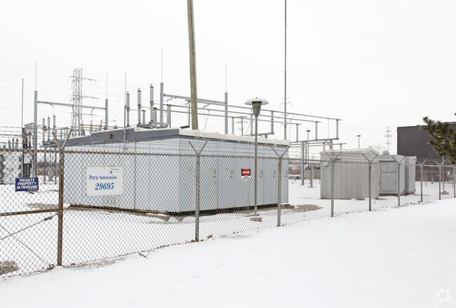
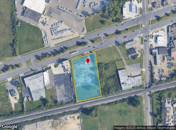
Property Record
29695 Michigan Ave, Inkster, MI 48141

NEARBY LISTINGS FOR SALE OR LEASE
Property Detail
29695 Michigan Ave
Detroit-Warren-Dearborn, MI
Vanvlear
44-012-99-0008-000
26H1 H2A H2B2B THAT PART OF THE SE 1/4 OF SEC 26 DESCRIBED AS BEGINNING AT A POINT ON THE SLY LINE OF MIC- HIGAN AVE DISTANT
Industrialgeneral
Wayne
X
Michigan
26163C0240F
0008
2024
2.44 AC
2025
Airport District
570500
Detroit
480 SF
DEMOGRAPHICS near 29695 Michigan Ave
1 Mile
3 Mile
5 Mile
2024 Total Population
8,421
102,533
250,426
2029 Population
8,275
99,075
240,874
Pop Growth 2024-2029
(1.73%)
(3.37%)
(3.81%)
Average Age
37
39
40
2024 Total Households
3,145
40,108
101,158
HH Growth 2024-2029
(1.84%)
(3.44%)
(3.86%)
Median Household Inc
$36,560
$54,048
$60,551
Avg Household Size
2.60
2.50
2.40
2024 Avg HH Vehicles
1.00
2.00
2.00
Median Home Value
$96,470
$138,421
$157,312
Median Year Built
1960
1957
1958
Nearby Places
Map Layers
Map Styles
 Street
 Aerial
- Restaurants
- Banks
- Shops
- Fitness
- Groceries
PUBLIC TRANSPORTATION
COMMUTER RAIL
Dearborn (Wolverine - Amtrak)
DRIVE
WALK
Distance
Dearborn (Wolverine - Amtrak)
11 min
5.2 mi
AIRPORT
Detroit Metro Wayne County
DRIVE
WALK
Distance
Detroit Metro Wayne County
16 min
8.0 mi
Windsor International
DRIVE
WALK
Distance
Windsor International
50 min
30.8 mi
Freight Ports
Port of Toledo
DRIVE
WALK
Distance
Port of Toledo
72 min
55.6 mi
Nearby Properties
Address
Land Use
TOTAL SIZE
Lot Size
Zoning
Address
Land Use
TOTAL SIZE
Lot Size
Zoning
857,173 SF
84.70 AC
M-1/COND
Address
Land Use
TOTAL SIZE
Lot Size
Zoning
186,738 SF
15.89 AC
RM-MLTI
Address
Land Use
TOTAL SIZE
Lot Size
Zoning
960 SF
62.42 AC
RC-REG
Address
Land Use
TOTAL SIZE
Lot Size
Zoning
463,642 SF
22.82 AC
Address
Land Use
TOTAL SIZE
Lot Size
Zoning
328,480 SF
11.54 AC
IA
Address
Land Use
TOTAL SIZE
Lot Size
Zoning
196,930 SF
9.93 AC
Address
Land Use
TOTAL SIZE
Lot Size
Zoning
138,541 SF
8.65 AC
Address
Land Use
TOTAL SIZE
Lot Size
Zoning
467,594 SF
34.54 AC
IND-B IND
Address
Land Use
TOTAL SIZE
Lot Size
Zoning
99.86 AC
Address
Land Use
TOTAL SIZE
Lot Size
Zoning
109,250 SF
26.52 AC
M-T
Address
Land Use
TOTAL SIZE
Lot Size
Zoning
142,269 SF
8.62 AC
Address
Land Use
TOTAL SIZE
Lot Size
Zoning
Address
Land Use
TOTAL SIZE
Lot Size
Zoning
58,958 SF
2.15 AC
BC
Address
Land Use
TOTAL SIZE
Lot Size
Zoning
127,017 SF
6.91 AC
Address
Land Use
TOTAL SIZE
Lot Size
Zoning
176,883 SF
10.83 AC
Address
Land Use
TOTAL SIZE
Lot Size
Zoning
93,425 SF
7.75 AC
Address
Land Use
TOTAL SIZE
Lot Size
Zoning
150,420 SF
11.83 AC
Address
Land Use
TOTAL SIZE
Lot Size
Zoning
93,202 SF
25.98 AC
M1-LIG
Address
Land Use
TOTAL SIZE
Lot Size
Zoning
314,418 SF
28.06 AC
Address
Land Use
TOTAL SIZE
Lot Size
Zoning
103,706 SF
10.33 AC
Address
Land Use
TOTAL SIZE
Lot Size
Zoning
53,263 SF
2.80 AC
Address
Land Use
TOTAL SIZE
Lot Size
Zoning
50,974 SF
8.48 AC
Address
Land Use
TOTAL SIZE
Lot Size
Zoning
186,112 SF
13.42 AC
M1-LIG
Address
Land Use
TOTAL SIZE
Lot Size
Zoning
61,200 SF
10.10 AC
Address
Land Use
TOTAL SIZE
Lot Size
Zoning
110,371 SF
8.68 AC
Address
Land Use
TOTAL SIZE
Lot Size
Zoning
111,699 SF
10.08 AC
Address
Land Use
TOTAL SIZE
Lot Size
Zoning
97,740 SF
4.47 AC
Address
Land Use
TOTAL SIZE
Lot Size
Zoning
54,143 SF
2.52 AC
RC-REG
Address
Land Use
TOTAL SIZE
Lot Size
Zoning
93,059 SF
26.53 AC
M-T
Address
Land Use
TOTAL SIZE
Lot Size
Zoning
149,828 SF
1.78 AC
The World's #1 Commercial Real Estate Marketplace
Connect with us
© 2025 CoStar Group
The information above has been obtained from sources believed reliable. While we do not doubt its accuracy we have not verified it and make no guarantee, warranty or representation about it. It is your responsibility to independently confirm its accuracy and completeness. Any projections, opinions, assumptions, or estimates used are for example only and do not represent the current or future performance of the property. The value of this transaction to you depends on tax and other factors which should be evaluated by your tax, financial, and legal advisors. You and your advisors should conduct a careful, independent investigation of the property to determine to your satisfaction the suitability of the property for your needs.