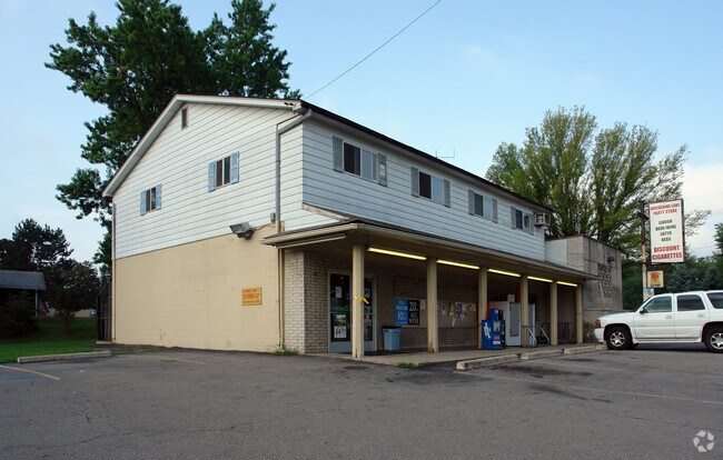
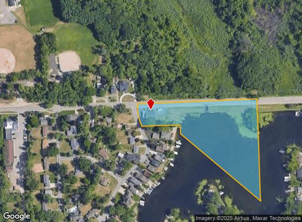
Property Record
297 Glengary Rd, Wolverine Lake, MI 48390

NEARBY LISTINGS FOR SALE OR LEASE
Property Detail
297 Glengary Rd
Detroit-Warren-Dearborn, MI
Stuarts Oak Island
17-22-431-027
T2N, R8E, SEC 22 THAT PART OF NE 1/4 OF SE 1/4 LYING NELY OF 'STUART'S OAK ISLAND SUB' EXC BEG AT NW COR OF LOT 1 OF SD SUB, TH NWLY 48 FT ALG RD, TH S 88-45-00 E 222.50 FT, TH S 01-15-00 W TO NE COR OF SD LOT 1, TH N 85-35-00 W 201.83 FT TO BEG 4.26
Supermarket
Oakland
A
Michigan
26125C0486F
1
2024
0.50 AC
2024
Central I-96 Corridor
134600
Detroit
4,823 SF
DEMOGRAPHICS near 297 Glengary Rd
1 Mile
3 Mile
5 Mile
2024 Total Population
6,284
51,452
136,136
2029 Population
6,186
50,964
134,724
Pop Growth 2024-2029
(1.56%)
(0.95%)
(1.04%)
Average Age
43
42
43
2024 Total Households
2,635
21,305
56,608
HH Growth 2024-2029
(1.63%)
(0.97%)
(1.12%)
Median Household Inc
$100,846
$88,445
$91,097
Avg Household Size
2.40
2.40
2.40
2024 Avg HH Vehicles
2.00
2.00
2.00
Median Home Value
$289,242
$297,929
$333,691
Median Year Built
1972
1987
1988
Nearby Places
Map Layers
Map Styles
 Street
 Aerial
- Restaurants
- Banks
- Shops
- Fitness
- Groceries
PUBLIC TRANSPORTATION
AIRPORT
Detroit Metro Wayne County
DRIVE
WALK
Distance
Detroit Metro Wayne County
42 min
32.4 mi
Freight Ports
Port of Toledo
DRIVE
WALK
Distance
Port of Toledo
91 min
74.1 mi
Nearby Properties
Address
Land Use
TOTAL SIZE
Lot Size
Zoning
Address
Land Use
TOTAL SIZE
Lot Size
Zoning
352,614 SF
53.31 AC
BI
Address
Land Use
TOTAL SIZE
Lot Size
Zoning
614,079 SF
57.44 AC
Address
Land Use
TOTAL SIZE
Lot Size
Zoning
659,897 SF
53.96 AC
AI
Address
Land Use
TOTAL SIZE
Lot Size
Zoning
400,505 SF
26.50 AC
Address
Land Use
TOTAL SIZE
Lot Size
Zoning
367,354 SF
62.73 AC
AI
Address
Land Use
TOTAL SIZE
Lot Size
Zoning
188,643 SF
12.81 AC
IV
Address
Land Use
TOTAL SIZE
Lot Size
Zoning
269,975 SF
23.88 AC
AI
Address
Land Use
TOTAL SIZE
Lot Size
Zoning
115,400 SF
9.38 AC
BI
Address
Land Use
TOTAL SIZE
Lot Size
Zoning
7,646 SF
24.55 AC
RM1
Address
Land Use
TOTAL SIZE
Lot Size
Zoning
222,664 SF
21.10 AC
BI
Address
Land Use
TOTAL SIZE
Lot Size
Zoning
196,222 SF
Address
Land Use
TOTAL SIZE
Lot Size
Zoning
227,946 SF
20.96 AC
AI
Address
Land Use
TOTAL SIZE
Lot Size
Zoning
26.54 AC
RM-1
Address
Land Use
TOTAL SIZE
Lot Size
Zoning
7,646 SF
24.55 AC
RM-1
Address
Land Use
TOTAL SIZE
Lot Size
Zoning
20.33 AC
RM-1
Address
Land Use
TOTAL SIZE
Lot Size
Zoning
118,592 SF
Address
Land Use
TOTAL SIZE
Lot Size
Zoning
169,638 SF
16.39 AC
Address
Land Use
TOTAL SIZE
Lot Size
Zoning
206,191 SF
23.73 AC
Address
Land Use
TOTAL SIZE
Lot Size
Zoning
2,080 SF
68.30 AC
MM
Address
Land Use
TOTAL SIZE
Lot Size
Zoning
227,399 SF
14.73 AC
II
Address
Land Use
TOTAL SIZE
Lot Size
Zoning
236,315 SF
35.86 AC
AI
Address
Land Use
TOTAL SIZE
Lot Size
Zoning
206,191 SF
24.88 AC
BI
Address
Land Use
TOTAL SIZE
Lot Size
Zoning
94,264 SF
4.24 AC
BI
Address
Land Use
TOTAL SIZE
Lot Size
Zoning
128,868 SF
13.25 AC
BI
Address
Land Use
TOTAL SIZE
Lot Size
Zoning
18.54 AC
RM-1
Address
Land Use
TOTAL SIZE
Lot Size
Zoning
135,714 SF
14.72 AC
BI
Address
Land Use
TOTAL SIZE
Lot Size
Zoning
236,821 SF
15.45 AC
AI
Address
Land Use
TOTAL SIZE
Lot Size
Zoning
140,310 SF
Address
Land Use
TOTAL SIZE
Lot Size
Zoning
97,080 SF
12.53 AC
BI
Address
Land Use
TOTAL SIZE
Lot Size
Zoning
140,310 SF
17.16 AC
BI
The World's #1 Commercial Real Estate Marketplace
Connect with us
© 2025 CoStar Group
The information above has been obtained from sources believed reliable. While we do not doubt its accuracy we have not verified it and make no guarantee, warranty or representation about it. It is your responsibility to independently confirm its accuracy and completeness. Any projections, opinions, assumptions, or estimates used are for example only and do not represent the current or future performance of the property. The value of this transaction to you depends on tax and other factors which should be evaluated by your tax, financial, and legal advisors. You and your advisors should conduct a careful, independent investigation of the property to determine to your satisfaction the suitability of the property for your needs.